CHUVA International Workshop May 2013 São Paulo, Brazil
|
|
|
- Adriano Andrade Palha
- 8 Há anos
- Visualizações:
Transcrição
1 CHUVA International Workshop May 2013 São Paulo, Brazil Time 9:00 Abstract Number Open Session 9: : The CHUVA Field Campaign: Overview NUMERICAL MODELING SESSION #1 WEDNESDAY MAY 08th, 2013 HRLAMENS - A PILOT PROJECT ON ENSEMBLE PREDICTION USING HIGH RESOLUTION LIMITED AREA MODELS Title Modeling cloud and rainfall formation near Belem and Santa Maria with OLAM (Ocean Land Atmosphere Model) Authors L. Machado, C. Morales, D. Vila, M. A. Silva Dias, G. Fisch, R. Albrecht, J. Cohen, E. Nascimento, M. Sakamoto C. Cunningham, C. Saulo, W. Anabor, G. Camponogara, J.-P. Chaboureau, M. A. Silva Dias, S. Freitas, Y. García Skabar, L. Machado, E. Nascimento, M. Nicolini, M. Pulido, J. Ruiz, P. Salio, D. Santos, M. Saucedo, R. Stockler, E. Vendrasco R. R. Silva, A. Gandu, J. Cohen, R. Haas 10: Modeling cloud and rainfall formation near Fortaleza with OLAM (Ocean Land Atmosphere Model) A. Gandu, R. R. Silva, R. Haas, A. Costa 10: :30-11:00 COFFEE BREAK High Resolution Model-Satellite-Radar Space and Time Scale Cloud Organization: The Santa Maria Case Study. NUMERICAL MODELING SESSION #2 L. Machado, J.-P. Chaboureau. 11: MODEL INTERCOMPARISON FOR EVENTS OCURRED AT SANTA MARIA SUL EXPERIMENT L. Amaral, C. Eichholz, V. Virpiccinini 11: H C E CHUVA S M 11: Validation of the BRAMS high resolution simulations by satellite radiance comparison R. Negri, L. Machado 11: December 10, 2012 MCS during CHUVA campaign: event forecast-ability using WRF M. Illha, V. Anabor 12: :15-14:00 LUNCH BREAK 14: : Evaluation of precipitation simulated over middle-latitude land by CPTEC AGCM single-column model (SCM) NUMERICAL MODELING SESSION #3 Analysis of precipitation in operational simulations of WRF in case of intense convection over Rio Grande do Sul State: Case Study December 11, 2012 WRF MODEL ASSESSMENT TO THE WIND PROFILE AND THERMODYNAMIC CHARACTERISTICS DURING THE CHUVA PROJECT ALCANTARA STATION 2010 C. Matsudo, C. Saulo, C. Cunningham, W. Anabor, G. Camponogara, J.-P. Chaboureau, M. A. Silva Dias, S. Freitas, Y. García Skabar, L. Machado, E. Nascimento, M. Nicolini, M. Pulido, J. Ruiz, P. Salio, D. Santos, M. Saucedo, R. Stockler, E. Vendrasco S. Figueroa, E. Ramirez, P. Kubota D. Daniel, D. Custódio, P. Oliveira, E. Nascimento, V. Anabor, E. Piva, F. Puhales A. Silva, G. Fisch

2 14: EVALUATION OF A BIN CLOUD MODEL USING DATA FROM CHUVA PROJECT FOR FORTALEZA, CEARA G. Almeida, L. Franklin, J. Leal Jr. BOUNDARY LAYER AND SURFACE PROCESSES SESSION 14: Spatial distribution of meteorological variables during severe weather events in CHUVA-Sul 15: Could LIDAR methods automatically detect the top of ABL? Case studies for Santa Maria / CHUVA-SUL 15: :30-16:00 COFFEE BREAK A comparative analysis between daily cycles of shortwave radiation from CHUVA Experiments at Vale do Paraíba and Santa Maria 16:00-17:30 ROUND TABLE - Dataset Control, Numerical Modeling, Boundary Layer and Surface Processes 18:00-19:30 ICE BREAK COCKTAIL G. Silva, O. Acevedo, P. Oliveira, H. Zimmermann, E. Nascimento G. Moreira, E. Landulfo, L. Peres, G. Mariano, R. Bourayou T. Kaufmann, G. Fisch Moderators: G. Fisch, M. A. Silva Dia, S. Freitas, C. Cunningham Datasets: radiosondes, balloons, tower, meteo statins, modeling Time Abstract Number CLOUD PROCESSES AND PRECIPITATION SESSION #1 THURSDAY MAY 09th, 2013 Title 9: GNSS Observations of Deep Convective Timescales in the Amazon D. K. Adams, S. Gutman, K. Holub, D. Pereira 9: PRELIMINARY STUDIES OF THE APPLICATION OF GNSS TO PRECIPITATION NOWCASTING L. Sapucci, L. Machado, I. Costa, L. Avanco 9: Relationship between Amazon biomass burning aerosols and rainfall over La Plata Basin G. Camponogara, M. A. F. Silva Dias, G. G. Carrió 9: : Preparation of a filter to correct drop size distributions of Parsivel disdrometer based on the particle speed limitation Weather radar systems and techniques at different frequencies and polarizations for quantitative precipitation estimation and severe weather monitoring I. Costa, L. Machado Authors L. Baldini, V.Chandrasekar, R. Bechini 10: Radar calibration C. Morales, R. Albrecht, T. Biscaro 10:30-11:00 COFFEE BREAK CLOUD PROCESSES AND PRECIPITATION SESSION #2 11: ICE WATER PATH STUDY USING PASSIVE MICROWAVE SENSORS DURING THE CLOUD LIFE CYCLE R. Braga, D. Vila 11: Characterization of the microphysics of ice using CHUVA X-band radar and TMI and MADRAS brightness temperatures A. Martini, N. Viltard, L. Machado, T. Biscarro 11: The Cloud and Rain Liquid Water Characteristics of Different Precipitation Regimes in Brazil A. Calheiros, L. Machado 11: AEROSOLS IMPACTS ON CLOUD DYNAMICS M. Cecchini, L. Machado 12: Cirrus clouds observation in Santa Maria, Rio Grande do Sul during the experiment Chuva Sul. B. Barja, H. Barbosa, R. Bourayou

3 12: SEVERE STORM DURING THE CAMPAIGN OF PROJECT CHUVA IN THE CITY OF BELÉM I. Mello, J. Cohen 12:30-14:00 LUNCH BREAK 14: CLOUD PROCESSES AND PRECIPITATION SESSION #3 INFLUENCE OF LOCAL CIRCULATION ON SPATIAL AND TEMPORAL DISTRIBUTION OF THE PRECIPITATION NEAR THE NEGRO AND SOLIMÕES RIVERS CONFLUENCE REGION M. Santos, M. A. Silva Dias, E. Freitas 14: Micro Squall Line in Belem region T. Amaral Neto, J. Cohen, L. Machado 14: Space and time Characteristics of Convective clouds during chuva campaigns W. Lima, L. Machado 14: SSMI/S Satellite Rainfall Retrievals during CHUVA-GLM Experiment D. Vila, N. Viltard, L. Machado, W. Lima 15: Use of CHUVA data to improve and validate the BRAIN rain retrieval algorithm N. Viltard, L. Machado, D. Vila 15:15-16:30 ROUND TABLE - Dataset Control, Cloud Processes and Precipitation Moderators: L. Machado, N. Viltard, D. Vila, L. Baldini Datasets: raingauges, DSD, MRR, radars, radiometer 16:30-17:00 COFFEE BREAK Time FUTURE FIELD EXPERIMENTS 17: Observations and Modeling of the Green Ocean Amazon (GoAmazon2014/5) S. T. Martin 17: : Interactions between urban and forest emissions in Manaus, Amazonia: The Brazilian component of GoAmazon Aerosol, Cloud, Precipitation, and Radiation Interactions and Dynamics of Convective Cloud Systems (ACRIDICON) 18: RELAMPAGO: following CHUVA steps... 19:00 SOCIAL EVENT (To be determined...) Abstract Number 8: CLOUD ELECTRIFICATION PROCESSES SESSION FRIDAY MAY 10th, 2013 Title SYNOPTIC AND THERMODYNAMIC CHARACTERIZATION OF SPRITE PRODUCING CONVECTIVE SYSTEMS OBSERVED IN DURING THE CHUVA SUL CAMPAIGN 8: Space-time Evolution of Sprite Producing Thunderstorms During CHUVA Sul Campaign in : Calibration of correction factors for the daily lightning quantities of starnet network using data from Field Mill, Belém campaign, CHUVA Project. P. Artaxo, M. A. Silva Dias M. Wendisch, L. Machado, U. Pöschl, K. Longo, M. Andreae, P. Artaxo, D. Rosenfeld, M. Silva Dias, H. Schlager, G. Fisch, A. Ehrlich, A. Manzi, B. Stevens, R. Souza P. Salio, S. Nesbitt, D. Cecil, T. Lang, L. Machado, R. Albrecht, E. Nascimento Authors R. Anchayhua, R. Azambuja, F. São Sabbas, A. Morais F. T. São Sabbas, R. Azambuja, R. Anchayhua, A. Morais W. Moreira Frota, B. Rocha, J. de Sá, L. Dentel, J. Pissolato Filho 9: Lightning activity associated to Amazonian coastal squall lines: a casestudy L. Dentel, B. Rocha, J. Souza, R. Holle, J. Saraiva 9: Thunderstorms and lightning activity in São Paulo metropolitan area during CHUVA-GLM Vale do Paraiba field experiment R. Albrecht, C. Morales, R. Blakeslee, J. Bailey, S. Goodman, H. Höller, E. Anselmo, J. Neves, E. Mattos, T. Biscaro, L. Machado

4 9: Characteristics of the X-Band Polarimetric Radar Associated With the Lightning Electrical Activity E. Mattos, L. Machado 9: Lightning and Polarimetric Radar Behavior of Incipient Thunderstorms in CHUVA E. Williams, E. Mattos, L. Machado, A. Saraiva 10: I P C L P CHUVA B C 10:15-10:45 COFFEE BREAK 10: LIGHTNING DETECTION SYSTEMS SESSION #1 São Paulo Lightning Mapping Array (SP-LMA): Network Assessment and Analyses for Intercomparison Studies and GOES-R Proxy Activities 11: Additions to the GLM proxy data set from CHUVA measurements 11: Ground-based and space-borne lightning observations during CHUVA 11: Using Lightning Mapper Array to evaluate the lightning detection signatures at VLF, LF and VHF systems C. Morales, R. Albrecht M. Lacerda, C. Morales, E. Anselmo, R. Albrecht, W. Rocamora, K. Fernandes, R. Jaques R. Blakeslee, J. Bailey, L. Carey, S. Goodman, S. Rudlosky, R. Albrecht, C. Morales, E. Anselmo, J. Neves M. Bateman, S. Goodman, R. Blakeslee, R. Albrecht, J. Bailey, D. Mach H. Höller, H.-D. Betz, C. Morales, R. Blakeslee, J. Bailey, R. Albrecht 11: ANALYSIS OF THE TLS200 NETWORK DEPLOYED DURING THE CHUVA CAMPAIGN IN BRAZIL A. Nag, M. Murphy, R. Said 12: O R O L I S G Lightning Observations at VLF, LF, and VHF Frequencies 12: Performance Comparison between Different Lightning Datasets during CHUVA Campaign 12:30-14:00 LUNCH BREAK 14: LIGHTNING DETECTION SYSTEMS SESSION #2 COMPARATIVE ANALYSIS OF BRASILDAT TOTAL LIGHTING NETWORK FOR THE VALE DO PARAIBA CHUVA CAMPAIGN 14: Electrostatic fields observed during the CHUVA campaign 14: RAMMER NETWORK OBSERVATIONS DURING THE SUMMER OF 2011/ : Upward lightning observations from towers in São Paulo, SP, Brazil and comparison with Lightning Location Systems data K. Cummins, R. Blakeslee, L. Carey, J. Bailey, M. Bateman, S. Goodman H. Zheng, R. Holzworth, M. Hutchins, J. Brundell, S. Heckman, O. Pinto Jr. K. Naccarato, O. Pinto Jr E. Anselmo, C. Morales, J. Neves, G. Beneduzi, M. Lacerda, R. Albrecht A. Saraiva, O. Pinto Jr, G. Zepka, E. Lu, L. Campos, L. Antune, J. Alves, T. Buzato M. Saba, A. Paiva, K. Naccarato, C. Schumann, R. Albrecht, M. Ferro 15: Data Analysis of upward lightning in Jaragua Peak C. Schumann, M. Saba, M. Ferro, A. Paiva, R. Jaques 15: :30-16:00 COFFEE BREAK On the relation between return stroke peak current provided by lightning location systems and its peak luminosity obtained from high-speed video cameras Preliminary results 16:00-18:00 ROUND TABLE ON CLOUD ELECTRIFICATION PROCESSES AND LIGHTNING DETECTION SYSTEMS WORKSHOP ENDS L.. Campos, J. Alves, A. Saraiva, E. Williams, O. Pinto Jr. Moderators: C. Morales, R. Albrecht Dataset: field-mills, LLS, fast/slow antennas, highspeed cameras

5 WRF MODEL ASSESSMENT TO THE WIND PROFILE AND THERMODYNAMIC CHARACTERISTICS DURING THE CHUVA PROJECT ALCANTARA STATION 2010 Adaiana F. G. da Silva 1 ; Gilberto F. Fisch 1,2 1 Instituto Nacional de Pesquisas Espaciais (INPE), Centro de Previsão do Tempo e Estudos Climáticos (CPTEC), São José dos Campos, SP, Brasil 2 Departamento de Ciência e Tecnologia Aeroespacial (DCTA), Instituto de Aeronáutica e Espaço (IAE), São José dos Campos, SP, Brasil O Centro de Lançamento de Alcântara (CLA) é considerado o portal brasileiro para o espaço. De lá podem ser lançados satélites de telecomunicação, coleta de dados ambientais, sensoriamento remoto, entre outras aplicações, através do Veículo Lançador de Satélites (VLS), bem como são realizados experimentos científicos (por exemplo, de microgravidade) por meio de foguetes de sondagem fabricados no Brasil (VSB30, VS40, etc.), como parte integrante do Programa Espacial Brasileiro (AEB, 2012). As características do vento podem impactar direta e profundamente a trajetória de um foguete, podendo desviá-lo, causar imprevistos e até mesmo acidentes. Por este motivo é muito importante conhecer o regime de vento local em termos das características do perfil vertical. Não apenas seus padrões climatológicos, mas também suas condições exatas no momento do lançamento são cruciais para a segurança da operação. Podem-se verificar as condições meteorológicas através de medidas observacionais instantâneas imediatamente antes do lançamento, mas neste momento todo o equipamento já deve estar montado, checado e preparado. Um complemento para o prognóstico da determinação do vento é a previsão feita a partir de modelagem numérica. Observações realizadas com antecedência geram as condições iniciais necessárias para simular a dinâmica da atmosfera e representar o estado futuro a partir do tempo presente. Os modelos regionais refinam a grade dos modelos globais (10 5 m) para meso (10 4 m e 10 5 s) ou micro-escala (10 3 m e 10 3 s). Desta forma, através das condições iniciais e de contorno fornecidas pelos modelos globais, é possível captar as interações locais e ter uma melhor representação regional ou até mesmo pontual. Neste trabalho, o modelo atmosférico WRF (Weather Research and Forecasting), núcleo ARW (Advanced Research WRF), foi escolhido por se tratar do estado-da-arte em modelos numéricos
, bem como são")
6 (CARVALHO et al., 2012), além de ser um software moderno, livre, de código aberto, fácil manipulação e pela liberdade na configuração das simulações em termos de parâmetros numéricos, físicos e dinâmicos, o que permite grande adequação ao estudo específico. A importância da utilização deste modelo está também no desenvolvimento de uma autonomia operacional do Setor de Meteorologia do CLA para a realização de previsões locais às vésperas de uma operação de lançamento. Na região equatorial, onde o CLA está localizado, o regime de ventos é dominado pelos ventos alísios, que são fortes, persistentes e predominantemente de leste, com uma rotação sazonal de nordeste (época chuvosa) para sudeste (época seca), em função do posicionamento da Zona de Convergência Intertropical (ZCIT). Além disto, por se localizar próximo ao oceano, o CLA também sofre influências do efeito de brisa marítima, a qual é intensificada no período de seca da região. (FISCH, 1999) Em específico, este trabalho teve como objetivo principal avaliar a performance do modelo WRF na previsão do vento no CLA através da comparação dos resultados gerados pelo modelo com dados de radiossondagens para o período de 19 a 25 de março de 2010, representativo do período chuvoso da região, caracterizado por ventos mais fracos. O período seco da região, com ventos fortes, também foi abordado no trabalho completo de dissertação de Mestrado que deu origem a esse resumo. Entretanto, como dados do Projeto Chuva foram utilizados somente para a avaliação do período chuvoso, somente este será tratado aqui. As radiossondagens foram obtidas da campanha realizada durante o Projeto Chuva GPM 2010, INPE estação Alcântara). As medidas foram realizadas nos 4 horários sinóticos diários (00:00, 06:00, 12:00 e 18:00 UTC), com o aparelho da marca Vaisala, modelo RS92-SVG. O modelo WRF foi inicializado com dados gerados pela previsão do modelo global GFS, do National Center of Atmospheric Research (NCEP), com resolução espacial de 0,5 x 0,5 (aproximadamente 55 x 55 km para a latitude local) e temporal de 6 horas, disponíveis em Os dados do terreno foram fornecidos pelo United States Geological Survey (USGS) (disponíveis em: com resolução espacial de 30 de arco. Todas as simulações foram realizadas com 42 níveis na vertical, três domínios quadrados e centralizados no CLA com dimensões de 900, 264 e 76 km 2 (Figura 1), sendo um domínio mãe e dois aninhados, com comunicação bidirecional de dados entre eles. O espaçamento da grade do domínio maior foi de 9x9 km, reduzindo

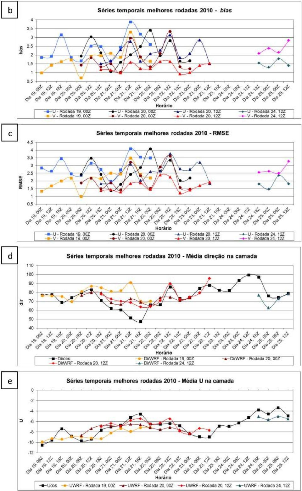
7 na proporção de 3 até a grade de 1x1 km no domínio menor, com passos de tempo de 45, 15 e 5 s para os domínios 1, 2 e 3, respectivamente. Simulações foram iniciadas a cada 12 horas (às 00 e às 12 UTC), com tempo de integração de 72 horas, incluso o tempo inicial de spin-up de 6 horas. A camada de interesse deste estudo é até os primeiros 5000 m, pois esta é a altura em que pode ocorrer influência do vento na determinação da trajetória de veículos em lançamento (FISCH, 1999). Figura 1 Configuração de tamanhos dos domínios aninhados. Em geral, para avaliar quantitativamente a acurácia de modelos numéricos, utilizam-se métricas estatísticas para comparar e quantificar dados observados e simulados. Para a comparação dos dados observados com as saídas do modelo WRF foram utilizadas três métricas estatísticas diferentes: bias (absoluto), RMSE e índice de Willmott (d) (WILLMOTT, 1981) para as variáveis velocidade (Vel) e as componentes U e V, calculados da seguinte forma: 1 n n i 1 (1) bias Viés P O 1 n n i 1 RMSE EQM P O 2 (2) d 1 n i 1 n i 1 P O 2 P O O O 2 (3) onde: n = número de níveis verticais; P = previsão, O = observação, O = média das observações, no caso, valor médio da camada.

8
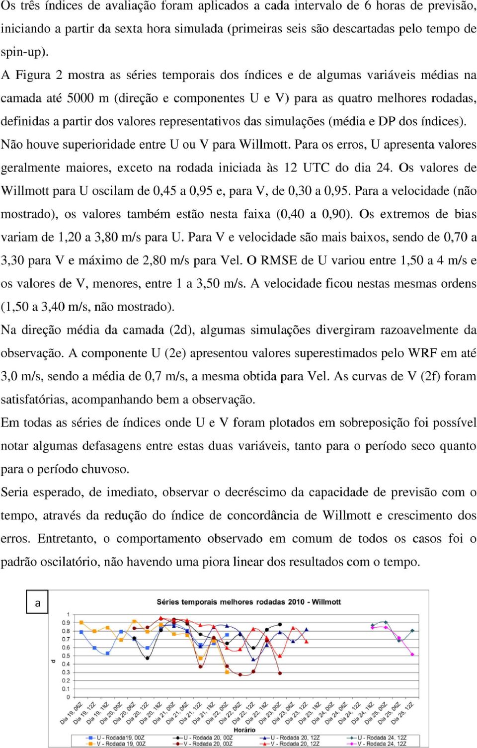
9
10

11 geralmente na forma de atrasos do modelo em relação à observação, de 1 a 2 horas ou mais. Quando ocorreu o posicionamento correto de núcleos de chuva, sua intensidade foi sempre muito subestimada pelo modelo. Devido à metodologia utilizada, não foi possível quantificar com precisão a quantidade de chuva subestimada. Um exemplo que merece destaque foi a forte precipitação observada pelo radar sobre o CLA durante 15 horas praticamente ininterruptas, das 16 UTC do dia 21 às 07 UTC do dia 22 de março de 2010, com núcleos de até 60 dbz, equivalente a aproximadamente 100 mm/h. Nenhuma das rodadas que incluíram este intervalo temporal foi capaz de representar tal evento extremo. Somente após o cessar das chuvas observadas o modelo começou a representar fortes núcleos aos arredores do CLA, mas representando no máximo 30 mm/h e deslocados, já que o núcleo principal foi observado sobre o CLA (Figura 3). Nestes horários já não há mais nenhuma precipitação significativa observada pelo radar. É possível que o modelo global (GFS) tenha carregado este atraso em seus arquivos de previsão, utilizados como dados de entrada. Figura 3 Campos de precipitação acumulada (WRF) e imagens de radar em raio 30 km. Forte núcleo de precipitação sobre o CLA. Modelo não representou. A Figura 4a mostra o campo das 13 UTC do dia 22 de março. Analisando as imagens de radar em horários próximos, tanto anteriores quanto posteriores, percebeu-se que os núcleos se assemelhavam com as observações do sistema que passou pela região de

12 Alcântara entre 10 e 12 UTC. Ou seja, o modelo WRF representou a chuva com atraso de aproximadamente 2 horas. Isto pode ser um indicativo de que as nuvens estavam se deslocando mais rapidamente do que calculado pelo modelo WRF, mostrando uma defasagem temporal. a b c Figura 4 Atraso temporal na rodada das 00 UTC do dia 22 de março. Evolução do sistema no WRF (esquerda) e observada pelo radar. Como conclusões, obteve-se que o modelo WRF consegue representar o perfil do vento no CLA de forma razoável, dentro de suas limitações. Os valores alcançados pelo índice de Willmott foram considerados satisfatórios de acordo com limites encontrados em outros estudos. Porém, não foi possível concluir que, depois de passado certo tempo de integração numérica (em intervalo de horas), as simulações tivessem apresentado um mesmo tipo de comportamento padrão em termos de melhora ou piora da qualidade de previsão. Em geral, o modelo superestimou a velocidade do vento médio observado na camada em até 2,0 m/s, com média de 0,70 m/s. Mesmo assim, acredita-se que, dentre as opções de parametrizações da CLP disponíveis, a escolhida para a realização deste trabalho (MYNN2,5) se mostrou eficiente para os objetivos a que foi definida, ou seja, representar a distribuição de momentum local de acordo com as características da estação. O modelo WRF, com a configuração default de microfísica de nuvens, não consegue capturar a presença de chuva em termos de posicionamento e intensidade. Este tema deve ser ainda melhor estudado em trabalhos futuros.

13 AGÊNCIA ESPACIAL BRASILEIRA (AEB). Plano Brasil: defesa geopolítica tecnologia inovação. Disponível em: < Acesso em: 03 abr CARVALHO, D.; ROCHA, A.; GÓMEZ-GESTEIRA, M.; SANTOS, C. A sensitivity study of the WRF model in wind simulation for an area of high wind energy. Environmental Modelling & Software, v. 33, p , FISCH, G. Características do perfil vertical do vento no Centro de Lançamento de foguetes de Alcântara (CLA). Revista Brasileira de Meteorologia, v. 14, n. 1, p , GISLER, C. A. F. Análise do perfil de vento na camada limite superficial e sistemas meteorológicos atuantes no Centro de Lançamento de Alcantâra p. (INPE TDI/1536). Dissertação (Mestrado em Meteorologia) - Instituto Nacional de Pesquisas Espaciais, São José dos Campos, Disponível em: < Acesso em: 31 out WILLMOTT, C. J. On the validation of models. [S.l: s.n.], 1981.
. Revista Brasileira de Meteorologia, v. 14, n. 1, p. 11-21, 1999. GISLER, C. A. F.")

14

15 The Cloud and Rain Liquid Water Characteristics of Different Precipitation Regimes in Brazil Alan J. P. Calheiros 1 and Luiz A. T. Machado 2 1 alan.calheiros@cptec.inpe.br, 2 luiz.machado@cptec.inpe.br 1,2 Instituto Nacional de Pesquisas Espaciais, Centro de Previsão de Tempo e Estudos Climáticos, Cachoeira Paulista, SP, Brazil ABSTRACT Between 2010 and 2012, the CHUVA project collected information regarding cloud and rain trends in different precipitation regimes in Brazil. CHUVA had four field campaigns, located in the North, Northeast and Southeast regions of Brazil, covering the semi-arid, Amazonas, coastal and mountain regions. The purpose of this study is to present statistics related to the integration of cloud and rain liquid water and the profiles for different cloud types and regimes. The synergy of several instruments allows us to describe the cloud process characteristics and to classify rain events. Microwave radiometer, LiDAR, radar, and disdrometer were employed in this study. The rain type classification was made using vertical profiles of reflectivity (VPR) and polarimetric variables from dual-polarization radar (XPOL). The profiles and integrated cloud liquid water (ILW C ) was retrieved with a microwave ground-based radiometer using a neural network. For rainy conditions, the profiles from the liquid water content (LWC R ) and their integrated (ILW R ) properties were estimated by Micro Rain Radar (MRR) and XPOL VPRs. For non-precipitating clouds, the ILW C values were larger for the sites in Northeast Brazil near the coast than for the other regions. For rainy cases, distinct LWC R profiles and ILW R were observed for different rain classifications and regions with a distinctive rainfall regime. The ILW R for the convective systems show the highest values, followed by stratiform and warm systems. The clouds in the Vale do Paraiba and Belem showed the largest reflectivity in the mixed and glaciated layers, respectively. In contrast, the coastal sites show larger values of cloud and rain liquid water content for non-precipitating and warm clouds. The Vale and Belem clouds present the deepest clouds and larger convective cloud liquid water. Several analyses are presented, describing the cloud process and the differences among the regions.

16 CHUVA International Workshop, May 8-10, 2013 ANALYSIS OF THE TLS200 NETWORK DEPLOYED DURING THE CHUVA CAMPAIGN IN BRAZIL Amitabh Nag 1, Martin J. Murphy 1, and Ryan K. Said 1 1 Vaisala Inc., Louisville, Colorado, USA Abstract: The CHUVA campaign was held in the vicinity of São Luiz do Paraitinga, Brazil from October 2011 to March One of the objectives of the CHUVA lightning mapping campaign was to perform measurements of total lightning activity, map lightning channels, and characterize in detail the lightning discharges in the region. Vaisala installed a five sensor network consisting of its TLS200 Total Lightning Sensor which combines very high frequency (VHF) interferometry with low frequency (LF) magnetic direction finding and time-of-arrival technologies. The network operated from January through March 2012 and detected total lightning activity over a region with a radius of approximately 100 km around São Paulo. During this period several severe thunderstorms occurred in the region. The TLS200 network detected a total of cloud-to-ground flashes in January through March, A larger number of cloud-to-ground flashes occurred during February than in January and March. Various characteristics of the lightning activity, including cloud-toground flash density, peak current distribution, and the ratio of cloud and cloud-to-ground discharges, were examined. Our analysis also illustrates the cloud lightning mapping capability of the VHF part of the TLS200 sensor. Cloud lightning detection performance of a lightning locating system is inherently difficult to quantify. Cloud lightning flashes or ICs may last from several hundred milliseconds to about a second. They may have several vertical and horizontal branches that can extend several kilometers or more spatially. The electromagnetic radiation field signature of an IC flash measured at distances of several tens of kilometers or more typically consists of a few tens to hundreds of electromagnetic field pulses spread over the entire duration of the flash. Typically, pulses in cloud discharges have amplitudes that are smaller than that of first return strokes in cloud-to-ground discharges. Cloud flash detection efficiency is defined as the percentage of the total number of IC flashes occurring in a certain period of time over a certain geographical area that are detected by a network. An IC flash is said to be detected if at least one pulse in the flash is detected and reported by the network. Similarly, cloud pulse detection efficiency is defined as the percentage of the total number of pulses in all cloud flashes (again, in a certain period of time over a certain geographical area) that are detected and reported by the network. However, obtaining a ground-truth estimate of the total number of cloud pulses is not practical due to the range of pulse amplitudes, and it is much more error prone than obtaining a ground-truth estimate of the total number of cloud flashes. Hence cloud flash detection efficiency of a lightning detection network is the only practical statistic. To improve cloud flash detection efficiency, an increase in sensor sensitivity (that is, higher gain and/or lower threshold) is required due to the tendency of cloud pulses to have lower amplitudes than return strokes. Cloud lightning detection at LF, where fewer sensors can be used to cover a given area, is considered to have growing importance. Given this, our objective is to quantify the cloud lightning detection capabilities of the TLS200 network deployed in CHUVA, particularly flash detection efficiency and spatial mapping capability at LF and VHF, respectively.

17 RAMMER NETWORK OBSERVATIONS DURING THE SUMMER OF 2011/2012 A. C. V. Saraiva 1 ; O. Pinto Jr. 1 ; G. S. Zepka 1 ; E. S. A. M. Luz 1 ; L. Z. S. Campos 1 ; L. Antunes 1 ; J. Alves 1 ; T. S. Buzato 1 1. INPE - National Institute for Space Research, São José dos Campos, São Paulo, Brazil. The RAMMER Project (Automated Multi-camera Network for Monitoring and Study of Lightning) is a network of automatically triggered high-speed cameras, designed to observe lightning flashes in the region of São José dos Campos-SP, Brazil. The cameras were assembled in weatherproof boxes with all equipment necessary to automatically trigger lightning flash events with the help of a photo sensor. Their initial set up provided high-speed videos of 2500 frames per second at 1200 x 500 pixels. They were strategically positioned to cover a total area of ~1000 km^2 and a common area of ~70 km^2. All cameras may capture flashes occurring inside the common area almost at the same time. The videos recorded simultaneously can be used for tridimensional reconstruction of the lightning channel. During the summer of 2011/2012, it was conducted the first campaign with two cameras operating continuously, and a third camera set up during some events. This first campaign was conducted in collaboration with a joint experiment with several institutions called CHUVA Project (Cloud processes of the main precipitation systems in Brazil: A contribution to cloud resolving modeling and to the Global Precipitation Measurement). Examples of analysis made with RAMMER data and other sensors installed during the CHUVA experiment will be shown. Among the examples there is an important study on the formation of bipolar flashes, a study of luminosity versus peak current, some observations of the same flash by two cameras, and the detection efficiency of the LLS (Lightning Location System) networks. As for the detection efficiency analysis, the high-speed camera data can be used as ground truth to evaluate the performance of the networks installed during the CHUVA experiment.

18 Abstract for CHUVA International Workshop 8-10 th May 2013 Audrey Martini (LATMOS) (1) (2) N. Viltard, L. A. Toledo Machado, T. Biscarro (1) LATMOS, (2) INPE Characterization of the microphysics of ice using CHUVA X-band radar and TMI and MADRAS brightness temperatures (2) CHUVA campaign is aimed at deploying a series of instruments in various locations over Brazil in order to better characterize the various rain regimes. Among those instruments, the X- Band dual polarization Doppler radar has a polarimetric capability, allowing us to get information using the combination of the various polarimetric variables measured by the radar, it is possible to access to a certain extent the type of particles that were observed within a given radar bin. Simultaneously, the radar classically gives the surface rain associated with those particles and the various regions of the rain system. Megha-Tropiques is a Franco-Indian satellite to study the water and energy cycle in the - of its main instrument MADRAS. The latter is a 9-channel passive microwave radiometer dedicated mainly to precipitation retrieval. Bauer et al (2005) showed that the most critical source of uncertainties in the precipitation retrieval over land comes from the ice microphysics characteristics. In the framework of the Megha-Tropiques mission we tried to improve the parameterization of precipitating ice in the radiative transfer model used to performed the retrieval of rain from the measured brightness temperatures. The aim of this study is not to get more into the details of particles classification but rather to test if the radar PID can be somewhat correlated to the 85 GHz brightness temperature in order to explain the effect of particles density and the ice content on the scattering. The knowledge of the properties of the ice precipitations is a very important information in order to retrieve accurately the rain from a vector of microwave brightness temperatures (Tb), particularly over land where the surface emissivity masks most of the rain/precipitation contribution for all frequencies below ~40 GHz. The next step will be to build a database of cases in various situations: oceanic, continental, coastal using CHUVA data set over Brazil.

19 Title: Cirrus clouds observation in Santa Maria, Rio Grade do Sul during the experiment Chuva Sul. Authors: Boris Barja (1), Henrique Barbosa (1), Riad Bourayou (2). (1) Physics Institute. University of Sao Paulo. Sao Paulo, SP, Brazil. (2) Center for Lasers and Application Nuclear and Energy Research Institute (IPEN/CNEN), Sao Paulo, SP, Brazil. Abstract: Cirrus clouds are an interesting point in the research of the atmosphere due their behavior and the effect on the earth radiation budget. They can affect the atmospheric radiation budget by reflecting the incoming solar radiation and absorbing the outgoing terrestrial radiation. Also, this cloud type is involved in the dehydration of the upper troposphere and lower stratosphere. So, it is interesting to increment the measurements of this type of clouds from the ground. During November and December 2012, through the CHUVA-SUL campaign, measurements with lidar in Santa Maria, Rio Grande do Sul were conducted. The system installed in Santa Maria site (29.8 S; 53.7 W, 100 m asl) was a single elastic-backscatter lidar using the wavelength of 532 nm. Some days with cirrus clouds lidar measurements were detected. Four days with presence of cirrus cloud are showed in the present study. These days, 7, 8, 19 and 28 November 2012, was selected due the persistence of cirrus clouds over many hours. The raw retrieval lidar signals and inverted backscatter coefficient profiles were analyzed for the selected days. Base and top height was obtained by analysis of raw signal and backscatter coefficient. Extinction coefficient profiles were obtained by the assumption of the lidar ratio. Cirrus cloud optical depth (COD) values were calculated, from the integration of the extinction coefficient between the base and top altitudes of the cirrus clouds.

20 Title Calibration of correction factors for the daily lightning quantities of starnet network using data from Field Mill, Belém campaign, CHUVA Project. Authors Willamy Moreira Frota1,4, Brigida Ramati Pereira da Rocha2-3, José Alberto Silva de Sá2, Laure Madeleine Dentel3,José Pissolato Filho4 1 Eletronorte 2 UFPA- Programa de Pós-Graduação em Engenharia Elétrica 3 SIPAM Sistema de Proteção da Amazônia, CTO/BE, Belém-PA 4 UNICAMP Abstract During the CHUVA project, Belém Campaign, models developed by Sá et al, 2011 (1.2) were used to forecast severe thunderstorms. These models use starnet network data for forecasting severe thunderstorms with lightning occurrence. During the period of Belém campaign some of the sensors of the starnet network had operational problems causing erros in the measured daily lightning quantities and affecting the performance of the forecast models. To optimize the forecast model, dynamic calibration factors for starnet network were developed taking into account the status of the network every 15 minutes; these factors were calibrated against field data observed by field mill in Belém. With the use of corrected data the forecast model had a success rate higher than 70% throughout the experiment. References: 1. Sá, José Alberto S., ALMEIDA, Arthur da Costa, ROCHA, B. R. P., MOTA, Maria Aurora S., SOUZA, José Ricardo Santos de, 2011, Lightning Forecast Based on Hourly Evolution of the Convective Available Potential Energy (CAPE) In: XIV International Conference on Atmospheric Electricity, Rio de Janeiro. Anais do XIV International Conference on Atmospheric Electricity. Rio de Janeiro 2. Sá, José Alberto S., ALMEIDA, Arthur da Costa, da Rocha, B.R.P., SOUZA, José Ricardo Santos de; 2011; Recurrent Self-Organizing Map for Severe Weather Patterns Recognition In: Recurrent Neural Network ed.croacia : INTECH, v.1
 were used to forecast severe thunderstorms. These models use starnet network data for forecasting severe thunderstorms with lightning occurrence.")
21 Data Analysis of upward lightning in Jaragua Peak Carina Schumann, Marcelo Magalhães Fares Saba, Marco Antônio Ferro, Amanda Romão de Paiva, Robson Jaques Observations of upward lightning from tall objects have been reported since Interest in this subject has grown recently, some of it because of the rapid expansion of wind power generation. Also, with the increasing number of tall buildings and towers, there will be a corresponding increase in the number of upward lightning flashes from these structures. Reports from recent field observations are beginning to address the nature of upward lightning initiation, but much still needs to be learned. Examples are studies of upward lightning from towers in winter thunderstorms in Japan (Wang and Takagi, 2010; and Lu et al., 2009) and summer thunderstorms in Europe (Miki et al., 2005; Flache et al., 2008; and Diendorfer et al., 2009; Zhou et al., 2011) and in North America (Mazur and Ruhnke, 2011; Hussein et al., 2011; Warner, 2011, and Warner et al., 2011). During CHUVA Campaign, a combination of high-speed video and standard definition video were used to record upward lightning flashes from multiple towers in Sao Paulo, a city located in southeastern Brazil with a population over 10 million people, an average elevation of around 800 meters above sea level, and a flash density of 15 flashes/km 2.year. The upward flashes initiated from two towers located on top of a 300 m tall hill. The heights of the towers were 130 m and 90 m. In this work, observations of 15 upward flashes made with these assets were analyzed along video observations, different Lightning Location Systems, electric field sensors and a lightning mapping array (LMA).
22 CHUVA Radar Measurements: Calibration and Attenuation Issues Carlos A. Morales 1, Rachel Albrecht 2 and Thiago Biscaro 2 1 Universidade de São Paulo (USP) 2 Instituto Nacional de Pesquisas Espaciais (INPE) Although the Mobile X-Band Dual Polarization weather radar employed in the 3 CHUVA field campaigns has been calibrated by Gemmatronik, the transmitted power is not updated in the radar equation and the calibration curve (power x signal) needs to be checked frequently. Furthermore, radome wetting could also cause some attenuation especially at the X-band frequency. Due to these artifacts it is important to evaluate the quality of such measurements, thus in this study we employ the methodology developed by Anagnostou et al. (2001) to retrieve the performance of CHUVA weather radar against the consolidate measurements of TRMM-PR. Finally, we will check if the rain attenuation algorithm used in the Gemmatronik software is able to recover the signal during some moderate to severe raining systems.
23 Using Lightning Mapper Array to evaluate the lightning detection signatures at VLF, LF and VHF systems Carlos A. Morales 1 and Rachel Albrecht 2 1 Universidade de São Paulo (USP) 2 Instituto Nacional de Pesquisas Espaciais (INPE) During the CHUVA-GLM field campaign 10 lightning detection networks were measuring the lightning activity in the São Paulo area. This unprecedented field campaign aloud a great opportunity for understanding the different lightning detection technologies, because assuming that the Lightning Mapper Array (LMA) can capture all the electromagnetic irradiated sources through a lightning discharge (breakdown, step leader, return stroke and dart leaders), it is possible to correlate in space and time what the VLF, LF and VHF lightning detection systems are really measuring, i.e., are they measuring sferics, leaders, return strokes, sources or a complete lightning channel. For this presentation we are going to use a case study on February 10 th, 2012, where the Lightning Imaging Sensor (LIS) onboard the TRMM satellite observed a storm in the São Paulo city. Coincident 90 seconds LIS measurements were compared with LMA, LINET, Vaisala-TLS200, EarthNetwork-BrazilDat, IMPACT/LPATS-RINDAT, ATDNet, STARNET, WWLLN, Vaisala-GLD360. In a preliminary analysis, the total lightning systems (LMA, LINET, TLS-200 and EarthNetwork) were very comparable in time, i.e., they had coincident time measurements, for the VLF and LF systems that were designed to measure mainly cloud to ground discharges, we did find some differences, i.e., sometimes all measure and most of the time just one or two. As for the presentation, we will be exploring these differences and spatial distribution that could provide insights on the type of discharges been observed.
24 HRLAMENS - A PILOT PROJECT ON ENSEMBLE PREDICTION USING HIGH RESOLUTION LIMITED AREA MODELS Cunningham, Christopher (1) ; Saulo, Celeste (2,3,4) ; Anabor, Wagner (5) ; Camponogara, Gláuber (6) ; Chaboureau, Jean-Pierre (7) ; Faus da Silva Dias, Maria Assunção (6) ; Ferreira, Márcio (1) ; Freitas, Saulo (1) ; García Skabar, Yanina (1,4,8) ; Machado, Luiz (1) ; Matsudo, Cynthia (9) ; Nascimento, Ernani (5) ; Nicolini, Matilde (2,3,4) ; Pulido, Manuel (4,10) ; Rodrigues, Joyce (1) ; Ruiz, Juan (2,3,4) ; Salio, Paola (2,3,4) ; Santos, Daniel (5) ; Saucedo, Marcos (2,4) ; Stockler, Rafael (1) ; Vendrasco, Eder (1) (1) (2) (3) (4) (5) (6) (7) (8) (9) (10) Instituto Nacional de Pesquisas Espaciais (INPE) - Centro de Previsão de Tempo e Estudos Climáticos (CPTEC), Cachoeira Paulista, Brasil Centro de Investigaciones del Mar y la Atmósfera (CONICET-UBA), Argentina Dpto Cs. de la Atmósfera y los Océanos, F CEyN, Universidad de Buenos Aires, Argentina UMI- IFAECI (CNRS/UBA/CONICET), Argentina Universidade Federal de Santa Maria (UFSM), Brasil Departamento de Ciências Atmosféricas, Instituto de Astronomia, Geofísica e Ciências Atmosféricas, Universidade de São Paulo L A U T CNRS T F e Facultad de Agronomía, Universidad de Buenos Aires, Argentina Servicio Meteorológico Nacional, Argentina Department of Physics, FACENA, Universidad Nacional del Nordeste, Corrientes, Argentina ABSTRACT The Center for Weather Forecast and Climate Studies (CPTEC), the University of Buenos Aires (UBA) and the Federal University of Paraná (UFPR) have been working on a project with focus on prediction of high impact weather events in the La Plata Basin (LPB). This project had been assembled following the framework of a Research and Development (ReD) project of the World Weather Research Program (WWRP). A recommendation from the Joint Scientific Committee-WWRP of adding a high-resolution component to the project, motivated a proposal for a mutual collaboration between CHUVA and LPB-ReD projects, which was presented and accepted by the occasion of the first CHUVA workshop. The main objective of the present work is to describe the details of this cooperative effort of combining global and high resolution models in an multi-model, multi-boundary ensemble that operates during the Sta. Maria campaign of the CHUVA project. The ensemble is composed of a core of 5 model configurations (2 executions of the BRAMS model plus 3 of the WRF model), which were integrated using CPTEC's supercomputing facilities, plus four other configurations, which were integrated on the participating institutions facilities. This core was designed to be driven by selected members of global Ensemble Prediction Systems (CPTEC and NCEP) and also to be homogeneous in domain size, horizontal and vertical resolution (2 km of grid space and 41 levels). Partner institutions participating in the project (WRF-UBA-UNNE, WRF-Argentina SMN, WRF-UFSM and MESO-NH-LA) have assisted the multi-model composition with their own model configurations. A selection procedure based on spatial pattern resemblance was developed to choose one member, likely the best one, to drive the high resolution LAM. Some insights on the role of the large scale, represented by the EPS boundary conditions, on the quality of the forecast are given. A companion work will give details an assessment of this intercomparison focused on precipitation forecasts quality during 4 particular events, when organized convection has been observed
25 High resolution model intercomparison for Convective Events during CHUVA Santa María Matsudo, Cynthia (1) ; Saulo, Celeste (2,3,4) ; Cunningham, Christopher (5), Anabor, Wagner (6) ; Camponogara, Gláuber (7) ; Chaboureau, Jean Pierre (8) ; Faus da Silva Dias, Maria Assunção (7) ; Freitas, Saulo (5) ; García Skabar, Yanina (1,4,9) ; Machado, Luiz (5) ; Nascimento, Ernani (6) ; Nicolini, Matilde (2,3,4) ; Pulido, Manuel (4,10) ; Ruiz, Juan (2,3,4) ; Salio, Paola (2,3,4) ; Santos, Daniel (6) ; Saucedo, Marcos (2,4) ; Stockler, Rafael (5) ; Vendrasco, Eder (5) Affiliation: (1) Servicio Meteorológico Nacional, Argentina (2) Centro de Investigaciones del Mar y la Atmósfera (CONICET UBA), Argentina (3) Dpto Cs. de la Atmósfera y los Océanos, F CEyN, Universidad de Buenos Aires, Argentina (4) UMI IFAECI (CNRS/UBA/CONICET), Argentina. (5) Instituto Nacional de Pesquisas Espaciais (INPE) Centro de Previsão de Tempo e Estudos Climáticos (CPTEC), Cachoeira Paulista, Brasil. (6) Universidade Federal de Santa Maria (UFSM), Brasil. (7) Departamento de Ciências Atmosféricas, Instituto de Astronomia, Geofísica e Ciências Atmosféricas, Universidade de São Paulo (8) Laboratoire d Aerologie, Universite de Toulouse and CNRS, Toulouse, France. (9) Facultad de Agronomía, Universidad de Buenos Aires, Argentina. (10) Department of Physics, FACENA, Universidad Nacional del Nordeste, Corrientes, Argentina. Abstract: CHUVA Santa María took place between November 6 and December 22, In order to provide high resolution operational forecasts during this period, several institutions designed specific model runs centered around Santa María, Brazil. Besides the interest of providing operational forecasts, the researchers of the participant institutions discussed model settings aimed at generating a high resolution model ensemble for the first time over South America. This ensemble includes 9 members, with varying resolution from 2 km to 48 km grid spacing, though most of them lie in the 4 2 km range. Particular model settings based in the WRF model (e.g. those adopted by UFSM, CPTEC, UBA UNNE, Argentina SMN) have been chosen in order to analyze the effect of alternative boundary conditions, grid resolution and planetary boundary layer parameterization. In turn, other models (e.g. BRAMS, MESO NH) have also been employed in order to compare different model performance. This work provides an assessment of this intercomparison focused on precipitation forecasts quality during 4 particular events, when organized convection has been observed. Besides subjective comparison of forecasted and observed accumulated precipitation fields; temporal precipitation variability, at each point where disdrometers and/or automated stations are available, will be analyzed and varied performance metrics will be presented.
26 A BCDE B F F BDC F F A E D A FD D E DEF DC C D F FD D F DED DC ABC D E F A A D E CA BA C D E A B A D E B D E A B D E CB A D ACA A D A B A B B B C B A AC AB CD DE F C C D F A FD F B C D D D A F C B FD DE C E AA F D F CD E F CD A D C DE D D A DA D D B FD D F DE DE D D A DA D D A DE D A D D A ED C F DE CD A C A E AA D A F C DE AB FF C A E AA D F D D D D A D D D A F C DE B C B DE F C FDC AB FD DA F DE E A AB AA AB D DE A DE F C A FDC FD DA D F DE DD C D D DE D D B A D DE A CC D F DE C C C C D FD DA ED F F DE FD C C C DE CC E D F AA FD D FF FB DE DE DFF F D D DE D F D C A D A DA D C AA F A A C D D AA C D A AA F AAB C C A D D FA C D F DE D D B C A D D F AAB D DE D A D D D D DE C A D EE D DA D D F C F D AD A D A D AD DA D C A D DD AA A D D A F A B DE AD DA D C A D A DDA D A DFF F D AAB DA D C A D
27 SSMI/S Satellite Rainfall Retrievals during CHUVA-GLM Experiment Daniel Vila, Nicolas Viltard, Luiz A. Machado, Wagner F. Lima This research effort regards the properties of the rain regimes over Brazil and the retrieval of instantaneous rain itself from passive microwave radiometers on board low-orbiting satellites like DMSP/SSMI/S. This study is conducted in the framework of the CHUVA-GLM campaign (Vale do Paraiba) which is aimed at deploying a series of instruments in various locations over Brazil in order to better characterize the various rainfall regimes. The performance of two different algorithms, the Bayesian Rain retrieval Algorithm Including Neural network (BRAIN) and Goddard Profile algorithm (GPROF), were carried out through a comparison between SSMI/S retrievals and radar data during November March 2012 over the Vale do Paraiba region (15 S - 31 S, 37 W - 57 W).
28 GNSS Observations of Deep Convective Timescales in the Amazon David K. Adams Centro de Ciencias de la Atmósfera, Universidad Nacional Autonoma de México, D.F., México and Programa de Pós Graduação em Clima e Ambiente, Universidade do Estado do Amazonas, Manaus, Amazonas, Brazil Seth I. Gutman and Kirk L. Holub, Earth System Research Laboratory, National Atmospheric and Oceanic Administration, Boulder, CO, USA Dulcineide S. Pereira Programa de Pós Graduação em Clima e Ambiente, Universidade do Estado do Amazonas, Manaus, Amazonas, Brazil In the tropics, deep precipitating convection dominates the weather and climate. Deep convection determines and is determined by the spatial/temporal distribution of water vapor resulting from complex interactions and feedbacks. However, observational systems, both surface-based and satellitebased, for the tropics tend to be inadequate for observing the convective-water vapor relationship, particularly for scales below mesoscale. For example, to understand the shallow-to-deep convective transition and organization on the mesoscale in the tropics and their relationship to the water vapor distribution, high frequency (~10 minutes), all weather observations are absolutely necessary. GNSS meteorology offers a durable, frequent, all-weather relatively inexpensive measures of column water vapor/precipitable water vapor. In this study, we utilize GNSS PWV for determining deep convective water vapor convergence time scales for the equatorial tropics, namely, Manaus in the central Amazon Basin. For a 3.5-year period, 320 observed deep convective events were analyzed. Two water vapor
29 convergence timescales are observed ; a roughly 8 hour period of weak water vapor convergence and a strong non-linear shallow-to-deep transition time scale of 4 hours. Within the 4 hour shallow-to-deep transition timescale, identifiable structure also exists. Maximum water vapor convergence is observed within 1 hour of the maximum precipitable water vapor value. During this final hour, rapid deep cloud growth and initiation of heavy precipitation occurs. This 4-hour shallow-to-deep transition time scale shows strikingly little variation, even when conditioned upon PWV values, diurnal vs. nocturnal convection, or measures of convective intensity (e.g., minimum cloud top temperature). This suggest that the shallow-to-deep transition time is an intrinsic property of convection. The longer 8 hour timescale does show some conditional dependency on different measures of convective intensity or thermodynamic environment. Analysis of these water vapor convergence time scales is currently being carried out for the CHUVA Belem GNSS Dense Network data set. Unlike Manaus, forcing in Belem is strongly associated with sea-breezes, providing an opportunity to examine the shallow-to-deep transition under different forcing. Result from this analysis as well as from Manaus will be presented. We argue that the GNSS-derived water vapor convergence time scale is valuable, not only for identify intrinsic characteristic of deep convection, but also for providing a metric for numerical modeling of deep tropical convection. CHUVA Manaus and GoAmazon2014 will provide and unprecedented opportunity to understand the shallow-to-deep transition in a Tropical continental region.
30 Lightning and Polarimetric Radar Behavior of Incipient Thunderstorms in CHUVA Earle Williams, MIT; Enrique Mattos, CPTEC; Luiz Machado, CPTEC; Antonio Saraiva, INPE Movies of radar PPI scans made at 6-minute intervals with the X-band polarimetric radar at UNIVAP during the wet season of have been used to identify 20 incipient isolated thunderstorms on five different storm days (November 10-13, March 13). A number of different lightning networks (BrazilDat, Lightning Mapping Array (LMA), Vaisala TLS200 and GLD360, LINET) have been used to characterize the lightning in each incipient storm. The 3D radar and lightning histories have been followed in each case from the initial radar echo to the first cloud-to-ground (CG) lightning flash. The sequence of events is remarkably reproducible and consistent with earlier studies in the Northern Hemisphere: initial radar echo, initial LMA radiation, initial intracloud (IC) flash, and initial CG flash (all negative polarity). The mean time interval from initial radar echo to first CG flash is 44 minutes, with a minimum time of 18 minutes and a maximum time of 78 minutes. The typical radar-measured storm diameter at the time of the initial CG flash is 15 km. In two storm cases, no CG flash was attained, but only IC flashes. In those cases, the maximum radar-measured diameter is only 7-8 km at the time of the lightning. These findings support the idea that a sufficiently extended charge reservoir is needed to enable a bridging of the nominal 5-7 km vertical distance between main negative charge center and ground by the initial CG flash. Of the 18 initial CG flashes, 16 of them (89%) are single-stroke flashes. This finding is consistent with the idea that when the main charge reservoir is compact, the positive leader intruding negative space charge is unable to continue its progression to stress the cutoff channel to ground and provide for a second stroke. Profiles of differential reflectivity are underway in the developing thunderstorms to distinguish negative ZDR values (associated with conical graupel) from positive ZDR values (associated with large raindrops below the freezing level and with supercooled drops above the freezing level.) The microphysical nature of the initial radar echo will also be diagnosed with this dual-pol method.
31 Characteristics of the X-Band Polarimetric Radar Associated With the Lightning Electrical Activity 1 Enrique Vieira Mattos, 1 Luiz Augusto Toledo Machado 1 Center for Weather Forecast and Climate Studies (CPTEC) National Institute of Space Research (INPE), Brazil This work have the objective of the evaluate the impact of cloud microphysics on the intensity of lightning electrical activity. As part of the fourth field campaign from CHUVA project called CHUVA-Geostationary Lightning Mapper-Paraíba Valley (CHUVA-GLM-Vale) has been used data from November 2011 to March 2012 on the Paraíba Valley in the Sao Paulo state, Brazil. Data of the horizontal reflectivity factor (Z h ) and vertical (Z v ), differential reflectivity (Z dr ), specific differential phase (K dp ) and the correlation coefficient ( hv ) from X-pol Radar; VHF sources from Lightning Mapper Array (LMA) and intra-cloud and cloud-to-ground lightning from Brasildat have been used. We have applied for all period data the correction of attenuation (for dbz and Z dr variables), correction when has precipitation over of the radar (for dbz, case called correction of wet radome) and correction of Z dr for the bias that exists when the radar points vertically. Analysis of the vertical profile from polarimetric variables was combined with different classes of electrical intensity of VHF sources like: (i) Weak, (ii) Moderate and (iii) Higher occurrence. An higher LMA occurrence was associated with an homogeny reflectivity vertical distribution, with higher values of reflectivity both inside of cloud warm and cold region. To differential reflectivity higher the intensity of electrical activity the distribution shifts for negative values of Z dr and close the height of the 7 Km. The variable K dp showed the same behavior of Z dr and for correlation factor distribution there was many events inside of warm cloud region. Analysis of mean profile also showed that higher electrical activity is correlated with existence of vertically oriented ice or conical graupel inside cold cloud region (Z dr more negative) and associated with fewer variability of hydrometeors kind (higher correlation factor). Furthermore the vertical distribution of VHF source has showed an classic electrical bipolar structure found in typical cloud for all the class of VHF sources. So in this way, this currently being determined the distribution pattern of polarimetrics variable for both centers of electrical charge. The same analysis has been done for negative and positive cloud-to-ground strokes and intra-cloud lightning.
32 Evandro M. Anselmo 1* Carlos A. Morales Rogriguez 1 Moacir Lacerda 2 Rachel Albrecht Institute of Astronomy, Geophysics and Atmospheric Sciences of USP 2 - Federal University of Mato Grosso do Sul 3 - National institute for Space Research - INPE Electrostatic fields observed during the CHUVA campaign Observing the Electric Field Mill measures during a thunderstorm, is notable the increased of electrostatic field associated with the electrification processes before the lightning occurrence. On CHUVA experiment, electrostatic field measurements were done by Field Mill network on 3 sites: in Belém PA where the Field Mill network had 3 sensors, Vale do Paraíba SP with 4 sensors and finally in Santa Maria RS that had the network with 5 sensors. Based on Electric Field Mill measures, the lightning occurrence was identify and studied the frequency of occurrence of electrical field values for 2 minutes before of each discharge. Values above 2000 V/m are most common in Belém PA and Santa Maria RS than Vale do Paraíba SP. In Belém PA the thunderstorms charge centers were often negative while in the Vale do Paraíba SP and Santa Maria RS, the polarity positive or negative, were more balanced. * evandro@model.iag.usp.br
33 Space-time Evolution of Sprite Producing Thunderstorms During CHUVA Sul Campaign in 2012 F. T. São Sabbas, R. Azambuja, R. Anchayhua, A. Morais Instituto Nacional de Pesquisas Espacias - INPE Av. dos Astronautas, 1.758, Jd da Granja São José dos Campos, SP, Brazil, During the months of November and December of 2012 the CHUVA Project performed the southern component of its campaigns, designated as CHUVA Sul. During this campaign, a suite of meteorological sensors was installed in the southernmost state of Brazil, Rio Grande do Sul. In order to perform observations of Transient Luminous Events TLEs, as part of this campaign, a team from the Atmospheric and Space Electrodynamical Coupling ACATMOS group of INPE set up optical observation sites at the headquarters of Anti-Granizo Fraiburgo-AGF company in Lebon Regis, Santa Catarina State, and at SIMEPAR radar site, near Curitiba, Paraná State. TLE is the generic term adopted to designate optical emissions excited in the upper atmosphere above thunderstorms as a consequence of intense electric fields of lighting discharges. They are of low luminosity, 100s of kr 10ths of MR, therefore only observable at night, and of short duration, few ms to few 100s of ms. They signal the electrodynamical coupling between the atmospheric layers and sprites are the most spectacular of these events. In the nights of 18-19/11/12 e 10-11/12 sprites above Rio Grande do Sul were recorded from the AGF site. A total of 17 sprites were recorded during these observations. This paper will present preliminary results describing the temporal and spatial evolution of the thunderstorms that generated the observed sprites. The work was performed using IR and Water Vapor images from the GOES 12 weather satellite, lightning data from the BrasilDAT network, and estimated locations of the sprites. We will present preliminary information on the life cycle of the storm, its expansion rate and the estimated overshooting of the cloud tops. We will also show the initial results of the relationship between the sprites and the lightning by identifying the cloud top regions above which sprites were generated, as well as the regions where the parent lightning may have withdraw charge from. Other aspects of this research, further characterizing the sprites observed, the parent lightning, the synoptic and thermodynamical scenario that led to the formation of the sprite producing thunderstorms and further details of the internal structure of the storms based on radar data will be presented in different papers from the co-authors of this work.
34 EVALUATION OF A BIN CLOUD MODEL USING DATA FROM CHUVA PROJECT FOR FORTALEZA, CEARA Gerson P. ALMEIDA², Levi M. FRANKLIN¹,², João Bosco V. LEAL JUNIOR², 1-Secretatia de Educação do Ceará, SEDUC 2- Universidade Estadual do Ceara, UECE Abstract. This study evaluated a bin cloud model, and compares results from simulations using data form the CHUVA project. Atmospheric conditions were taken from soundings performed in Fortaleza in April We compare rainfall rate to observations at four sites in Fortaleza. The analysis was performed in a qualitative way, ie, observation or not of rainfall. It is shown that the bin cloud model can represent appropriately most of the observation. Description of the model. The model is that described in Costa (1995), Almeida (1997), Costa et al., (2000) e Almeida e Santos (2007). On the cloud model advection is evaluated using the scheme of Bott (1989 a, b). An iteractive numerical procedure is used to calculate the stream function, using the vorticity equation as defined by Stone (1968) and Jacobs (1972). For turbulence closure we use a first order scheme, according to Smagorinsky (1963), Soong e Ogura (1973) We modified the model domain from 80x80 up to 230x230 grid points, with grid spacing of 80 meters both on the horizontal and vertical domain. Cloud Condensation Nuclei (CCN) were represented by 178 categories, with dry diameters ranging from 12 nm up to 15.2 m. The corresponding activation supersaturations ranging from 2.8% to 0.0% (ALMEIDA e SANTOS 2007). The bin cloud model uses 100 drops categories, with diameters ranging from 2.0 m to 1.0 (COSTA et al., 2000). Cloud microphysical process (activation, condensation/evaporation, collision coalescence and collisional break up) modify drop size distribution function and are evaluated using a modified Kovetz and Olund (1969) method. The
35 condensation process is calculated using a semi lagrangean scheme, as defined by Kogan (1991), producing realistic values for supersaturation. The model boundaries are defined as rigid, without slipping. To avoid numerical instability, absorbing levels are imposed at upper and lateral levels of the model. CCN distribution is evaluated for three regimes: maritime, polluted and intermediate. The three distributions follow the relation, where is the concentration in, and are constants, and is the supersaturation in. Values for and are: 245 and 0.33 for the maritime regime; 1275 and 0.72 for the intermadiate regime; and 2450 and for the polluted one. Methodology Comparisons were performed for 10 soundings, evaluating the accumulated precipitation simulated in 60 minutes. We performed a simulation control to evaluate the accumulated precipitation. Additional simulations were, then, compared the simulation control, varying the number of grid points and smoothing the data point of the sounding. For simulations presented here the model was configured with 150x150 grid points and we chose a maritime regime for the CCN distribution. The simulations of 1 hour was performed using a dynamic time steep of 5 second, and a microphysical time step of 0.25 seconds. We also carried out several simulations to evaluate the cloud evolution as a function of the sounding smoothing process. The smoothing is needed to mitigate spikes in thermal inversions. RESULTS. The cloud model can qualitatively represent about 45% of all precipitation events observed on the four collecting sites when the simulation control was used. Using smoothed sounding increase the representation to 54% of precipitation events observed on the four observational sites. Increasing grid point domain also increase the representation to 66% of the precipitation events
 April 9, 2011 at 05:37 UTC, (b) April 9, 2011 at 12:01 UTC, (c) April 9, 2011 at 18:01 UTC, (d) April 10, 2011 at 17:56 UTC, (e) April 11, 2011 at 11:41 UTC, (f), April 11, 2011 at 17:36 UTC,")
36 The figures below represent the simulation control for those days that produced precipitation. (a) April 9, 2011 at 05:37 UTC, (b) April 9, 2011 at 12:01 UTC, (c) April 9, 2011 at 18:01 UTC, (d) April 10, 2011 at 17:56 UTC, (e) April 11, 2011 at 11:41 UTC, (f), April 11, 2011 at 17:36 UTC, (g), April 11, 2011 at 23:36 UTC, (h) April 12, 2011 at 11:48 UTC (a) (e) (b) (f) (c) (g) (d) (h) CONCLUSIONS. The bin cloud model is able to represents qualitatively the amount of precipitation produced during observation of Projeto CHUVA in Fortaleza. In some events a quantitatively representation was also achieved. REFERENCES.
High resolution model intercomparison for Convective Events during CHUVA Santa María
 High resolution model intercomparison for Convective Events during CHUVA Santa María Matsudo, Cynthia(1); Saulo, Celeste(2,3,4); Cunningham, Christopher (5), Anabor, Wagner (6); Camponogara, Gláuber (7);
OPERAÇÃO, PESQUISA E DESENVOLVIMENTO PARA PREVISÃO DE EVENTOS EXTREMOS. José Antonio Aravéquia
 OPERAÇÃO, PESQUISA E DESENVOLVIMENTO PARA PREVISÃO DE EVENTOS EXTREMOS José Antonio Aravéquia Centro de Previsão do Tempo e Estudos Climáticos CPTEC Instituto Nacional de Pesquisas Espaciais INPE Centro
TEMPESTADES E TEMPO SEVERO DURANTE O EXPERIMENTO CHUVA-GLM VALE DO PARAÍBA
 TEMPESTADES E TEMPO SEVERO DURANTE O EXPERIMENTO CHUVA-GLM VALE DO PARAÍBA Rachel ALBRECHT 1*, Carlos MORALES 2, Enrique MATTOS 1, Thiago BISCARO 1, Luiz MACHADO 1, Evandro ANSELMO 2, João NEVES 2 1 CPTEC/INPE
Validação das observações feitas com o pluviômetro de garrafa PET na cidade de Belém-PA.
 Validação das observações feitas com o pluviômetro de garrafa PET na cidade de Belém-PA. Silvia Letícia Alves Garcêz¹, Maria Aurora Santos da Mota². ¹Estudante de Graduação da Universidade Federal do Pará,
COMPARAÇÃO DE MEDIDAS OBTIDAS POR RADAR DE SUPERFÍCIE E RADAR ORBITAL: UM ESTUDO DE CASO PARA O RADAR DE SÃO ROQUE
 COMPARAÇÃO DE MEDIDAS OBTIDAS POR RADAR DE SUPERFÍCIE E RADAR ORBITAL: UM ESTUDO DE CASO PARA O RADAR DE SÃO ROQUE Izabelly Carvalho da Costa 1 Carlos Frederico de Angelis 1 RESUMO Tendo em vista que a
EMPREGO DE MODELAGEM NUMÉRICA PARA ESTIMATIVA DE RADIAÇÃO SOLAR NO ESTADO DO CEARÁ
 EMPREGO DE MODELAGEM NUMÉRICA PARA ESTIMATIVA DE RADIAÇÃO SOLAR NO ESTADO DO CEARÁ Francisco José Lopes de Lima 1,2, Fernando Ramos Martins 1, Jerfferson Souza, 1 Enio Bueno Pereira 1 1 Instituto Nacional
Impacto dos padrões de circulação nos recursos de energia renovável na Ibéria
 Impacto dos padrões de circulação nos recursos de energia renovável na Ibéria EOLICA HIDRAULICA SOLAR Ricardo Machado Trigo (Univ. Lisboa) Agradecimentos: S. Jerez, D. Pozo-Vázquez, J.P. Montávez, S.M.
DESENVOLVIMENTO DA CAMADA LIMITE INTERNA NO CENTRO DE LANÇAMENTO DE ALCÂNTARA
 DESENVOLVIMENTO DA CAMADA LIMITE INTERNA NO CENTRO DE LANÇAMENTO DE ALCÂNTARA Luciana B. M. Pires 1, Gilberto Fisch 2, Ralf Gielow. RESUMO - Esse trabalho tem como objetivo estudar a estrutura da turbulência
Software reliability analysis by considering fault dependency and debugging time lag Autores
 Campos extraídos diretamente Título Software reliability analysis by considering fault dependency and debugging time lag Autores Huang, Chin-Yu and Lin, Chu-Ti Ano de publicação 2006 Fonte de publicação
Comparação entre Variáveis Meteorológicas das Cidades de Fortaleza (CE) e Patos (PB)
 e Patos (PB)") Comparação entre Variáveis Meteorológicas das Cidades de Fortaleza (CE) e Patos (PB) F. D. A. Lima 1, C. H. C. da Silva 2, J. R. Bezerra³, I. J. M. Moura 4, D. F. dos Santos 4, F. G. M. Pinheiro 5, C.
Comparação entre Variáveis Meteorológicas das Cidades de Fortaleza (CE) e Patos (PB) F. D. A. Lima 1, C. H. C. da Silva 2, J. R. Bezerra³, I. J. M. Moura 4, D. F. dos Santos 4, F. G. M. Pinheiro 5, C.
Empresa Brasileira de Infra-Estrutura Aeroportuária (INFRAERO), dbsantos@infraero.gov.br
, dbsantos@infraero.gov.br") ANÁLISE ESTATÍSTICA DA PREVISIBILIDADE DOS ÍNDICES TERMODINÂMICOS NO PERÍODO CHUVOSO DE 2009, PARA AEROPORTO INTERNACIONAL DE SALVADOR/BA Deydila Michele Bonfim dos Santos 1 Carlos Alberto Ferreira Gisler
ANÁLISE ESTATÍSTICA DA PREVISIBILIDADE DOS ÍNDICES TERMODINÂMICOS NO PERÍODO CHUVOSO DE 2009, PARA AEROPORTO INTERNACIONAL DE SALVADOR/BA Deydila Michele Bonfim dos Santos 1 Carlos Alberto Ferreira Gisler
Air Quality Photochemical Simulations using the system MM5 SMOKE CMAQ for Brazil
 NCQAr LAMMA UFRJ UFRJ CCMN IGEO LAMMA NCQAr Universidade Federal do Rio de Janeiro Centro de Ciências Matemáticas e da Natureza Instituto de Geociências - Departamento de Meteorologia Laboratório de Modelagem
SPATIAL DISTRIBUITION OF TURBITY IN A STRETCH OF MADEIRA RIVER MONITORING MADEIRA RIVER PROJECT PORTO VELHO (RO)
") SPATIAL DISTRIBUITION OF TURBITY IN A STRETCH OF MADEIRA RIVER MONITORING MADEIRA RIVER PROJECT PORTO VELHO (RO) 4th scientific meeting of the ORE-HIBAM. September 2011 4a Scientific Meeting ORE-HYBAM
SPATIAL DISTRIBUITION OF TURBITY IN A STRETCH OF MADEIRA RIVER MONITORING MADEIRA RIVER PROJECT PORTO VELHO (RO) 4th scientific meeting of the ORE-HIBAM. September 2011 4a Scientific Meeting ORE-HYBAM
SIMULAÇÃO DE UM CASO DE EVENTO EXTREMO DE CHUVA NA CIDADE DE MANAUS-AM COM O MODELO WRF: O CASO 08 DE MARÇO DE 2008 (RESULTADOS PRELIMINARES)
") SIMULAÇÃO DE UM CASO DE EVENTO EXTREMO DE CHUVA NA CIDADE DE MANAUS-AM COM O MODELO WRF: O CASO 08 DE MARÇO DE 2008 (RESULTADOS PRELIMINARES) Adriane Lima Brito¹ José Augusto Paixão Veiga 1 André Ferreira
SIMULAÇÃO DE UM CASO DE EVENTO EXTREMO DE CHUVA NA CIDADE DE MANAUS-AM COM O MODELO WRF: O CASO 08 DE MARÇO DE 2008 (RESULTADOS PRELIMINARES) Adriane Lima Brito¹ José Augusto Paixão Veiga 1 André Ferreira
Caracterização da Variabilidade do Vento no Aeroporto Internacional de Fortaleza, Ceará. Parte 2: Análise da Velocidade
 Caracterização da Variabilidade do Vento no Aeroporto Internacional de Fortaleza, Ceará. Parte 2: Análise da Velocidade Pollyanna Kelly de Oliveira Silva ¹, Maria Regina da Silva Aragão 2, Magaly de Fatima
ESTUDO DE DESCARGAS ELÉTRICAS ATMOSFÉRICAS NO SUL E SUDESTE DO BRASIL: ANÁLISE PRELIMINAR
 ESTUDO DE DESCARGAS ELÉTRICAS ATMOSFÉRICAS NO SUL E SUDESTE DO BRASIL: ANÁLISE PRELIMINAR Rosangela Barreto Biasi Gin, Augusto José Pereira Filho, Departamento de Ciências Atmosféricas-IAG, Universidade
ANÁLISE DO MODELO ETA COMPARADO COM DADOS OBSERVADO DA ESTAÇÃO EM MACEIÓ.
 ANÁLISE DO MODELO COMPARADO COM DADOS OBSERVADO DA ESTAÇÃO EM MACEIÓ. Allan Rodrigues Silva 1 Adriano Correia de Marchi 2 Roberto Fernando da F. Lyra 3 Rosiberto Salustiano da Silva Junior 3 Thalyta Soares
Pablo Oliveira, Otávio Acevedo, Osvaldo Moraes. Universidade Federal de Santa Maria, Santa Maria, RS
 COMPARAÇÃO ENTRE OBSERVAÇÕES DE TEMPERATURA E UMIDADE DE UMA REDE DE ESTAÇÕES EM SUPERFÍCIE E DADOS DE REANÁLISE NA REGIÃO DE CONFLUÊNCIA DOS RIOS TAPAJÓS E AMAZONAS Pablo Oliveira, Otávio Acevedo, Osvaldo
ANÁLISE TERMODINÂMICA DAS SONDAGENS DE CAXIUANÃ DURANTE O EXPERIMENTO PECHULA.
 ANÁLISE TERMODINÂMICA DAS SONDAGENS DE CAXIUANÃ DURANTE O EXPERIMENTO PECHULA. Dayana Castilho de Souza 1, Maria Aurora Santos da Mota 2, Júlia Clarinda Paiva Cohen 3 RESUMO Os dados utilizados neste estudo
Verificação da previsão numérica do tempo por ensemble regional no estado do Ceará
 Verificação da previsão numérica do tempo por ensemble regional no estado do Ceará Cleiton da Silva Silveira 1, Alexandre Araújo Costa 2, Francisco das Chagas Vasconcelos Júnior 3, Aurélio Wildson Teixeira
Neutron Reference Measurements to Petroleum Industry
 LABORATÓRIO NACIONAL DE METROLOGIA DAS RADIAÇÕES IONIZANTES IRD- Instituto de Radioproteção e Dosimetria Neutron Reference Measurements to Petroleum Industry Karla C. de Souza Patrão, Evaldo S. da Fonseca,
Digital Cartographic Generalization for Database of Cadastral Maps
 Mariane Alves Dal Santo marianedalsanto@udesc.br Francisco Henrique de Oliveira chicoliver@yahoo.com.br Carlos Loch cloch@ecv.ufsc.br Laboratório de Geoprocessamento GeoLab Universidade do Estado de Santa
MATERIAIS E METODOLOGIA
 QUANTIFICAÇÃO DA PRECIPITAÇÃO E A RELAÇÃO COM A PRESSÃO ATMOSFÉRICA EM UMA ÁREA DE CULTIVO DE MANGA NO MUNICÍPIO DE CUIARANA-PA SILVA, F. M. 1 ; TORRES, C.S.C. 2 ; SOUSA, A. M. L. 3 ; NUNES, H. G. G. C.
Modelo de Previsão de Relâmpagos Nuvem-Solo Utilizando Imagens de Satélite em Infravermelho
 Modelo de Previsão de Relâmpagos Nuvem-Solo Utilizando Imagens de Satélite em Infravermelho Enrique Vieira Mattos 1, Luiz Augusto Toledo Machado 2 1 Divisão de Satélites e Sistemas Ambientais DSA 2 Centro
Sazonalidade da temperatura do ar e radiação solar global em cidades de diferentes portes na Amazônia Brasileira.
 Sazonalidade da temperatura do ar e radiação solar global em cidades de diferentes portes na Amazônia Brasileira. Ingrid Monteiro Peixoto de Souza 1, Antonio Carlos Lôla da Costa 1, João de Athaydes Silva
Lucas de Assis Soares, Luisa Nunes Ramaldes, Taciana Toledo de Almeida Albuquerque, Neyval Costa Reis Junior. São Paulo, 2013
 COMPARATIVE STUDY OF THE ATMOSPHERIC DISPERSION MODELS AND THROUGH THE ANALYSIS OF AIR QUALITY IN THE METROPOLITAN REGION OF GRANDE VITÓRIA Lucas de Assis Soares, Luisa Nunes Ramaldes, Taciana Toledo de
SITUAÇÕES SINÓTICAS ASSOCIADAS ÀS DIFERENÇAS NAS PROPRIEDADES ÓPTICAS DA ATMOSFERA EM AMBIENTE URBANO
 SITUAÇÕES SINÓTICAS ASSOCIADAS ÀS DIFERENÇAS NAS PROPRIEDADES ÓPTICAS DA ATMOSFERA EM AMBIENTE URBANO Luciene Natali 1 Willians Bini 2 Edmilson Dias de Freitas 3 RESUMO: Neste trabalho é feita uma investigação
Implantação de sistema computacional aplicado a informações meteorológicas para internet.
 Autor: Irene Cristina Pereira Corrêa Orientador(a): Júlia Clarinda Paiva Cohen Co-orientador: Paulo Afonso Fischer Kuhn Filiação: Curso de Meteorologia / Universidade Federal do Pará E-mail: irenecristinacorrea@hotmail.com
ESTUDO MICROFÍSICO DE NUVENS AMAZÔNICAS AO SUL DA ZONA URBANA DE JI PARANÁ-RO E AO NORTE DE CRUZEIRO DO SUL-AC SEGUNDO OS DADOS DO LBA/SMOCC 2002.
 ESTUDO MICROFÍSICO DE NUVENS AMAZÔNICAS AO SUL DA ZONA URBANA DE JI PARANÁ-RO E AO NORTE DE CRUZEIRO DO SUL-AC SEGUNDO OS DADOS DO LBA/SMOCC 2002. Ednardo Moreira Rodrigues 1, Carlos Jacinto de Oliveira
Service quality in restaurants: an experimental analysis performed in Brazil
 . XIII INTERNATIONAL CONFERENCE ON INDUSTRIAL ENGINEERING AND OPERATIONS MANAGEMENT Energy that moves production: a dialogue among integration, project and sustainability 09-11 October 2007 Service quality
ASPECTOS METEOROLÓGICOS ASSOCIADOS A EVENTOS EXTREMOS DE CHEIAS NO RIO ACRE RESUMO
 ASPECTOS METEOROLÓGICOS ASSOCIADOS A EVENTOS EXTREMOS DE CHEIAS NO RIO ACRE Victor Azevedo Godoi 1, André Felipe de Matos Lopes 1, Audálio Rebelo Torres Jr. 1, Caroline R. Mazzoli da Rocha 2, Mariana Palagano
A Tool to Evaluate Stuck-Open Faults in CMOS Logic Gates
 FURG A Tool to Evaluate Stuck-Open Faults in CMOS Logic Gates Alexandra L. Zimpeck, Cristina Meinhardt e Paulo F. Butzen Summary Introduction Motivation Stuck-Open Faults Stuck-Open Faults in Nanometer
ANÁLISE DO COMPORTAMENTO DA TEMPERATURA E DA UMIDADE RELATIVA DO AR EM DIFERENTES LOCAIS DA CIDADE DE MOSSORÓ-RN.
 ANÁLISE DO COMPORTAMENTO DA TEMPERATURA E DA UMIDADE RELATIVA DO AR EM DIFERENTES LOCAIS DA CIDADE DE MOSSORÓ-RN. GIULLIANA M. MORAIS DE SOUSA 1, JOSÉ E. SOBRINHO 2, MÁRIO M. VILLAS BOAS 3, GERTRUDES M.
BR-EMS MORTALITY AND SUVIVORSHIP LIFE TABLES BRAZILIAN LIFE INSURANCE AND PENSIONS MARKET
 BR-EMS MORTALITY AND SUVIVORSHIP LIFE TABLES BRAZILIAN LIFE INSURANCE AND PENSIONS MARKET 2015 1 e-mail:mario@labma.ufrj.br Tables BR-EMS, mortality experience of the Brazilian Insurance Market, were constructed,
Relação entre a Precipitação Acumulada Mensal e Radiação de Onda Longa no Estado do Pará. (Dezembro/2009 a Abril/2010)
") Relação entre a Precipitação Acumulada Mensal e Radiação de Onda Longa no Estado do Pará. (Dezembro/2009 a Abril/2010) Adriana Hellen Ferreira Cordeiro¹, Nilza Araújo Pachêco² 1. Graduanda de Meteorologia
Relação entre a Precipitação Acumulada Mensal e Radiação de Onda Longa no Estado do Pará. (Dezembro/2009 a Abril/2010) Adriana Hellen Ferreira Cordeiro¹, Nilza Araújo Pachêco² 1. Graduanda de Meteorologia
DEPARTAMENTO DE ENGENHARIA CIVIL E ARQUITETURA
 SCHOOL YEAR 01/013 1 ST EXAM 013/01/16 08h00 DURATION: h00 THEORY QUESTIONS (maximum 45 minutes) 1. In a pumped trunk main system explain why the smallest technically viable diameter may not be the least
MECANISMOS FÍSICOS EM MÊS EXTREMO CHUVOSO NA CIDADE DE PETROLINA. PARTE 3: CARACTERÍSTICAS TERMODINÂMICAS E DO VENTO
 MECANISMOS FÍSICOS EM MÊS EXTREMO CHUVOSO NA CIDADE DE PETROLINA. PARTE 3: CARACTERÍSTICAS TERMODINÂMICAS E DO VENTO Roberta Everllyn Pereira Ribeiro 1, Maria Regina da Silva Aragão 2, Jaqueline Núbia
Estudo de caso de um sistema frontal atuante na cidade de Salvador, Bahia
 Estudo de caso de um sistema frontal atuante na cidade de Salvador, Bahia Fernanda Gonçalves Rocha 1 ; Maria Regina da Silva Aragão 2 1 Bolsista (CNPq), Programa de Pós-graduação em Meteorologia/DCA/UFCG,
Simulação de Evento de Tempo Extremo no Estado de Alagoas com o Modelo Regional BRAMS
 Simulação de Evento de Tempo Extremo no Estado de Alagoas com o Modelo Regional BRAMS Heriberto dos Anjos Amaro 1, Elisângela Gonçalves Lacerda 1, Luiz Carlos Baldicero Molion 2 1 Pontifícia Universidade
Mestrado Integrado Engenharia da Energia e do Ambiente, Faculdade Ciências da Universidade de Lisboa, 1/12
 , 6/10/009 On the web Course webpage! http:// solar.fc.ul.pt/pv_course PV blog http://solar-fcul.blogspot.com com Group page: http:// solar.fc.ul.pt On the web Radiation from the Sun Atmospheric effects
MARCELO DE LIMA BRAZ REDUÇÃO DA QUANTIDADE DE REPROCESSO NO SETOR DE PRODUÇÃO DE CALDOS ALIMENTÍCIOS NA EMPRESA DO RAMO ALIMENTÍCIO (ERA).
.") MARCELO DE LIMA BRAZ REDUÇÃO DA QUANTIDADE DE REPROCESSO NO SETOR DE PRODUÇÃO DE CALDOS ALIMENTÍCIOS NA EMPRESA DO RAMO ALIMENTÍCIO (ERA). Poços de Caldas / MG 2014 MARCELO DE LIMA BRAZ REDUÇÃO DA QUANTIDADE
MARCELO DE LIMA BRAZ REDUÇÃO DA QUANTIDADE DE REPROCESSO NO SETOR DE PRODUÇÃO DE CALDOS ALIMENTÍCIOS NA EMPRESA DO RAMO ALIMENTÍCIO (ERA). Poços de Caldas / MG 2014 MARCELO DE LIMA BRAZ REDUÇÃO DA QUANTIDADE
Análise do comportamento da temperatura e da umidade relativa do ar em diferentes locais da cidade de Mossoró-RN durante as quatro estações do ano.
 Análise do comportamento da temperatura e da umidade relativa do ar em diferentes locais da cidade de Mossoró-RN durante as quatro estações do. JOSÉ ESPÍNOLA SOBRINHO 1, HIDERALDO BEZERRA DOS SANTOS 2,
COMPARAÇÃO ENTRE MEDIDAS DE VELOCIDADE DO VENTO EM RIO GRANDE, RS, DE 2001 A 2006
 COMPARAÇÃO ENTRE MEDIDAS DE VELOCIDADE DO VENTO EM RIO GRANDE, RS, DE 2001 A 2006 Joel Rubert 1, Margareth Badejo dos Santos 2, Nisia Krusche 3 RESUMO: Diferenças entre as medidas de vento, realizadas
Facing challenges of Meteorology in tropical South America
 Facing challenges of Meteorology in tropical South America Maria Assunção F. S. Dias Center for Weather Forecasting and Climate Studies CPTEC National Institute for Space Research INPE ITWG 16 Angra dos
Avaliação da influência da convecção de meso-escala no prognóstico de precipitação do modelo WRF em Alta Resolução: Um Estudo de Caso.
 Avaliação da influência da convecção de meso-escala no prognóstico de precipitação do modelo WRF em Alta Resolução: Um Estudo de Caso. Alessandro Renê Souza do Espírito Santo1; Jeanne Moreira de Sousa1;
DESENVOLVIMENTO DO SISTEMA DE AVALIAÇÃO DE DADOS COLETADOS POR PCD S: MÓDULOS DE VENTO, TEMPERATURA E UMIDADE RELATIVA DO AR E RADIAÇÃO SOLAR
 DESENVOLVIMENTO DO SISTEMA DE AVALIAÇÃO DE DADOS COLETADOS POR PCD S: MÓDULOS DE VENTO, TEMPERATURA E UMIDADE RELATIVA DO AR E RADIAÇÃO SOLAR Mario Rodrigues Pinto de Sousa Filho FUNCEME Fortaleza mario.rodrigues@funceme.br
MELHORIAS NAS PREVISÕES DE PRECIPITAÇÃO COM A ASSIMILAÇÃO DE VAPOR D ÁGUA INTEGRADO.
 MELHORIAS NAS PREVISÕES DE PRECIPITAÇÃO COM A ASSIMILAÇÃO DE VAPOR D ÁGUA INTEGRADO. DEREK V. SCHUBERT 1, LUIZ F. SAPUCCI 2, JOÃO FRANCISCO GALERA MONICO 3 1 Bel. em Tecnologia da Informação, Bolsista,
ESTUDO DO CRESCIMENTO DE GOTÍCULAS E GOTAS NO CCNC-DSCC. PARTE ΙI: TEMPO DE CRESCIMENTO
 ESTUDO DO CRESCIMENTO DE GOTÍCULAS E GOTAS NO CCNC-DSCC. PARTE ΙI: TEMPO DE CRESCIMENTO Ednardo Moreira Rodrigues 1, Carlos Jacinto de Oliveira 2, Francisco Geraldo de Melo Pinheiro 2, Jonathan Alencar
USO DO SOFTWARE WINDOGRAPHER PARA ESTIMATIVAS DA VELOCIDADE DO VENTO EM ALTITUDE NUMA REGIÃO DO LITORAL CEARENSE
 USO DO SOFTWARE WINDOGRAPHER PARA ESTIMATIVAS DA VELOCIDADE DO VENTO EM ALTITUDE NUMA REGIÃO DO LITORAL CEARENSE Emerson Mariano da Silva 1 ; Flavio José Alexandre Linard 2 1 Universidade Estadual do Ceará
Tese / Thesis Work Análise de desempenho de sistemas distribuídos de grande porte na plataforma Java
 Licenciatura em Engenharia Informática Degree in Computer Science Engineering Análise de desempenho de sistemas distribuídos de grande porte na plataforma Java Performance analysis of large distributed
COMITÊ DO ESPECTRO PARA RADIODIFUSÃO - CER SPECTRUM DAY 16.08.2011 A REVISÃO DA REGULAMENTAÇÃO DO USO DA FAIXA DE 3,5 GHZ UMA NECESSIDADE COMPROVADA.
 COMITÊ DO ESPECTRO PARA RADIODIFUSÃO - CER SPECTRUM DAY 16.08.2011 A REVISÃO DA REGULAMENTAÇÃO DO USO DA FAIXA DE 3,5 GHZ UMA NECESSIDADE COMPROVADA. PAULO RICARDO H. BALDUINO 0 Conteúdo 1. Introdução
Project Management Activities
 Id Name Duração Início Término Predecessoras 1 Project Management Activities 36 dias Sex 05/10/12 Sex 23/11/12 2 Plan the Project 36 dias Sex 05/10/12 Sex 23/11/12 3 Define the work 15 dias Sex 05/10/12
The Indigenous Population of Brazil 1991 Population Census
 The Indigenous Population of Brazil 1991 Population Census Authors: Nilza Oliveira Martins Pereira (principal author), Tereza Cristina Nascimento Araujo, Valéria Beiriz, Antonio Florido- IBGE The definition
SOS CHUVA Contribution to RELAMPAGO
 SOS CHUVA Contribution to RELAMPAGO Luiz A T Machado, Rachel Albrecht, Edmilson Freitas, Eder Vendrasco, Madeleine Sanches, Jean-François Ribaud, Ariane Frassoni, Diego Enoré, Thiago Biscaro, Izabelly
Erasmus Student Work Placement
 Erasmus Student Work Placement EMPLOYER INFORMATION Name of organisation Address Post code Country SPORT LISBOA E BENFICA AV. GENERAL NORTON DE MATOS, 1500-313 LISBOA PORTUGAL Telephone 21 721 95 09 Fax
Variabilidade na velocidade do vento na região próxima a Alta da Bolívia e sua relação com a precipitação no Sul do Brasil
 Variabilidade na velocidade do vento na região próxima a Alta da Bolívia e sua relação com a precipitação no Sul do Brasil Luiz Carlos Salgueiro Donato Bacelar¹; Júlio Renato Marques ² ¹Aluno graduando,
VARIABILIDADE DA UMIDADE RELATIVA DO AR NA BACIA DE BARRA DOS COQUEIROS - CAÇU-GO 1
 VARIABILIDADE DA UMIDADE RELATIVA DO AR NA BACIA DE BARRA DOS COQUEIROS - CAÇU-GO 1 Lázara Fernanda Moraes de Carvalho UFG-CampusJataí lazarafernanda@hotmail.com Regina Maria Lopes UFG lopesgeo@yahoo.com.br
Simulação Gráfica e Visão Computacional. Soraia Raupp Musse
 Simulação Gráfica e Visão Computacional Soraia Raupp Musse Objetivo Analisar exemplos comerciais e do estado-da-arte científicos que utilizam dados reais para aprimorar a qualidade de simulações e animações.
Expansão Agrícola e Variabilidade Climática no Semi-Árido
 Expansão Agrícola e Variabilidade Climática no Semi-Árido Fabíola de Souza Silva 1, Magaly de Fatima Correia 2, Maria Regina da Silva Aragão 2 1 Bolsista PIBIC/CNPq/UFCG, Curso de Graduação em Meteorologia,
OCORRÊNCIA DE DESCARGAS ELÉTRICAS ATMOSFÉRICAS NO SUL DA AMÉRICA DO SUL DURANTE OS ANOS DE 2002 E 2003. Kellen Carla Lima 1 & Roseli Gueths Gomes 2
 OCORRÊNCIA DE DESCARGAS ELÉTRICAS ATMOSFÉRICAS NO SUL DA AMÉRICA DO SUL DURANTE OS ANOS DE 2002 E 2003 Kellen Carla Lima 1 & Roseli Gueths Gomes 2 RESUMO Neste trabalho é pesquisada a incidência de Descargas
Avaliação de Modelos Gaussianos para Fins Regulatórios Um Estudo para o Verão na Região de Nova Iguaçu, RJ
 Avaliação de Modelos Gaussianos para Fins Regulatórios Um Estudo para o Verão na Região de Nova Iguaçu, RJ VELLOSO, Maria Francisca Azeredo (1) ; CUNHA Bruno D Aiuto (2) ; PIMENTEL, Luiz Claudio Gomes
CORRELAÇÃO ENTRE DADOS DE VENTO GERADOS NO PROJETO REANALYSIS DO NCEP/NCAR E OBSERVADOS EM REGIÕES DO ESTADO DO CEARÁ.
 CORRELAÇÃO ENTRE DADOS DE VENTO GERADOS NO PROJETO REANALYSIS DO NCEP/NCAR E OBSERVADOS EM REGIÕES DO ESTADO DO CEARÁ. Cícero Fernandes Almeida Vieira 1, Clodoaldo Campos dos Santos 1, Francisco José Lopes
ABSTRACT. Palavras-chave: Aviso Meteorologia Especial, INMET, São Paulo. 1 - INTRODUÇÃO
 Avisos Meteorológicos Especiais: Um Estudo de Caso para a Cidade de São Paulo-SP Josefa Morgana Viturino de Almeida¹; Wagner de Aragão Bezerra². 1, 2 Meteorologista, Instituto Nacional de Meteorologia
INFLUÊNCIA DA CONDIÇÃO INICIAL NA SIMULAÇÃO DO EVENTO DE PRECIPITAÇÃO EXTREMA NA SERRA DO MAR
 INFLUÊNCIA DA CONDIÇÃO INICIAL NA SIMULAÇÃO DO EVENTO DE PRECIPITAÇÃO EXTREMA NA SERRA DO MAR José Roberto Rozante 1, Iracema F. A. Cavalcanti 2 RESUMO Chuvas intensas, em torno de 175 milímetros, ocorreram
PADRÃO SINÓTICO ATUANTE DURANTE O EVENTO DE PICO NA ESPESSURA ÓPTICA DE AEROSSÓIS SOBRE O OBSERVATÓRIO ESPACIAL DO SUL NO DIA 06 DE SETEMBRO DE 2007.
 PADRÃO SINÓTICO ATUANTE DURANTE O EVENTO DE PICO NA ESPESSURA ÓPTICA DE AEROSSÓIS SOBRE O OBSERVATÓRIO ESPACIAL DO SUL NO DIA 06 DE SETEMBRO DE 2007. LUCAS V. PERES 1, ELENICE KALL 2, DAMARIS K. PINHEIRO
INFLUÊNCIA DA RESOLUÇÃO HORIZONTAL NAS CONDIÇÕES INICIAIS E CONTORNO NAS PREVISÕES DE CHUVAS TROPICAIS
 INFLUÊNCIA DA RESOLUÇÃO HORIZONTAL NAS CONDIÇÕES INICIAIS E CONTORNO NAS PREVISÕES DE CHUVAS TROPICAIS S. C. Chou, J. R. Rozante, J. F. Bustamante Centro de Previsão de Tempo e Estudos Climáticos CPTEC
Carbon stocks and changes across a network of Atlantic Forest plots. Simone Vieira (NEPAM/UNICAMP, Brazil)
") Carbon stocks and changes across a network of Atlantic Forest plots Simone Vieira (NEPAM/UNICAMP, Brazil) Forest cover South America the greatest concentration of tropical forests in the world Amazonian
Carbon stocks and changes across a network of Atlantic Forest plots Simone Vieira (NEPAM/UNICAMP, Brazil) Forest cover South America the greatest concentration of tropical forests in the world Amazonian
ANÁLISE DE TEMPESTADES SEVERAS COM O SOFTWARE TITAN USANDO OS DADOS DO RADAR METEOROLÓGICO DE BAURU
 ANÁLISE DE TEMPESTADES SEVERAS COM O SOFTWARE TITAN USANDO OS DADOS DO RADAR METEOROLÓGICO DE BAURU Adelmo Antonio Correia 1 e José Carlos Figueiredo Resumo: Este trabalho visa analisar ocorrência de precipitação
Análise Termodinâmica de Santarém Durante o Experimento BARCA
 Análise Termodinâmica de Santarém Durante o Experimento BARCA MARCELA MACHADO POMPEU (1),FABRÍCIO MARTINS (2) MARIA AURORA SANTOS DA MOTA (3) MARIA ISABEL VITORINO (3) (1) Estudante de Pós Graduação em
UMA ANÁLISE CLIMATOLÓGICA DE RE-INCURSÕES DE MASSAS DE AR ÚMIDO NA REGIÃO DA BACIA DO PRATA DURANTE A ESTAÇÃO FRIA.
 UMA ANÁLISE CLIMATOLÓGICA DE RE-INCURSÕES DE MASSAS DE AR ÚMIDO NA REGIÃO DA BACIA DO PRATA DURANTE A ESTAÇÃO FRIA. Felipe Daniel C. Espindola, 12 Ernani de Lima Nascimento 1, Lincon T. Carabagialle 1
e-lab: a didactic interactive experiment An approach to the Boyle-Mariotte law
 Sérgio Leal a,b, João Paulo Leal a,c Horácio Fernandes d a Departamento de Química e Bioquímica, FCUL, Lisboa, Portugal b Escola Secundária com 3.º ciclo Padre António Vieira, Lisboa, Portugal c Unidade
Workshop com Usuários 2015
 Workshop com Usuários 2015 apresentado por Dr. Clezio Marcos De Nardin Gerente do Programa Embrace (INPE/CEA-LAC-DSS) Alertas Solares @climaespacial MCT / INPE / CEA LAC DSS - Programa EMBRACE 2 Escala
Sistemas de Reflectometria de Microondas e Ondas. Milimétricas para Plasmas de Fusão
 Sistemas de Reflectometria de Microondas e Ondas Milimétricas para Plasmas de Fusão M. Manso e L. Cupido Associação EURATOM / IST, Fusão Nuclear, 1049-001 Lisboa, Portugal. Introdução A produção comercial
3203 APERFEIÇOAMENTO DE UM MÉTODO DE PREVISÃO DE TEMPERATURAS MÁXIMAS PARA PELOTAS
 3203 APERFEIÇOAMENTO DE UM MÉTODO DE PREVISÃO DE TEMPERATURAS MÁXIMAS PARA PELOTAS Natalia Fedorova; Maria Helena de Carvalho; Benedita Célia Marcelino; Tatiane P. Pereira, André M. Gonçalves; Eliane P.
Resumo. Abstract. 1. Introdução
 Contribuições da Região Amazônica e do Oceano Atlântico nas chuvas intensas de Janeiro de 2004 sobre a Região Nordeste do Brasil Raimundo Jaildo dos Anjos Instituto Nacional de Meteorologia raimundo.anjos@inmet.gov.br
Variabilidade temporal de índice de vegetação NDVI e sua conexão com o clima: Biomas Caatinga Brasileira e Savana Africana
 Variabilidade temporal de índice de vegetação NDVI e sua conexão com o clima: Biomas Caatinga Brasileira e Savana Africana Humberto Alves Barbosa 1, Ivon Wilson da Silva Júnior 2 1 PhD, LAPIS/UFAL Maceió
Multicriteria Impact Assessment of the certified reference material for ethanol in water
 Multicriteria Impact Assessment of the certified reference material for ethanol in water André Rauen Leonardo Ribeiro Rodnei Fagundes Dias Taiana Fortunato Araujo Taynah Lopes de Souza Inmetro / Brasil
PRINCIPAIS SECAS OCORRIDAS NESTE SÉCULO NO ESTADO DO CEARÁ: UMA AVALIAÇÃO PLUVIOMÉTRICA
 PRINCIPAIS SECAS OCORRIDAS NESTE SÉCULO NO ESTADO DO CEARÁ: UMA AVALIAÇÃO PLUVIOMÉTRICA José M. Brabo Alves; Rubenaldo A. Silva; Everaldo B. Souza; Carlos A. Repelli Departamento de Meteorologia -Divisão
MUDANÇAS CLIMÁTICAS DOS EVENTOS SEVEROS DE PRECIPITAÇÃO NO LESTE DE SANTA CATARINA DE ACORDO COM O MODELO HADRM3P
 MUDANÇAS CLIMÁTICAS DOS EVENTOS SEVEROS DE PRECIPITAÇÃO NO LESTE DE SANTA CATARINA DE ACORDO COM O MODELO HADRM3P Gilson Carlos da Silva, 1,2 André Becker Nunes 1 1 UFPEL Brazil Pelotas gilson.carloss@ig.com.br
ÍNDICE K: ANÁLISE COMPARATIVA DOS PERIODOS CLIMATOLÓGICOS DE 1950-1979 E 1980-2009
 ÍNDICE K: ANÁLISE COMPARATIVA DOS PERIODOS CLIMATOLÓGICOS DE 1950-1979 E 1980-2009 Fellipe Romão Sousa Correia, Fabricio Polifke da Silva, Maria Gertrudes Alvarez Justi da Silva Universidade Federal do
Variabilidade temporal e espacial dos Raios e Chuva no Leste da Amazônia
 Variabilidade temporal e espacial dos Raios e Chuva no Leste da Amazônia Wanda Maria do Nascimento Ribeiro1, José Ricardo Santos de Souza, Venize de Assunção Teixeira, Ana Paula Paes dos Santos PPGCA-
CARACTERIZAÇÃO PLUVIOMETRICA POR QUINQUÍDIOS DA CIDADE DE PIRENOPOLIS - GO
 CARACTERIZAÇÃO PLUVIOMETRICA POR QUINQUÍDIOS DA CIDADE DE PIRENOPOLIS - GO Silva, M. A. G 1* ; Guimarães Junior, J. M; 1 Esteves, A. A. M; 2 Maciel, F. L; 3 Ucker, F.E; 1,3,4 Santos, F.C.V; 1, 3,4 Correchel,
Banca examinadora: Professor Paulo N. Figueiredo, Professora Fátima Bayma de Oliveira e Professor Joaquim Rubens Fontes Filho
 Título: Direção e Taxa (Velocidade) de Acumulação de Capacidades Tecnológicas: Evidências de uma Pequena Amostra de Empresas de Software no Rio de Janeiro, 2004 Autor(a): Eduardo Coelho da Paz Miranda
COMPORTAMENTO DA PREVISÃO DE PRECIPITAÇÃO SIMULADA PELO MODELO WEATHER RESEARCH AND FORECASTING (WRF) PARA O ESTADO DO ESPÍRITO SANTO.
 PARA O ESTADO DO ESPÍRITO SANTO.") COMPORTAMENTO DA PREVISÃO DE PRECIPITAÇÃO SIMULADA PELO MODELO WEATHER RESEARCH AND FORECASTING (WRF) PARA O ESTADO DO ESPÍRITO SANTO. HUGO ELY DOS ANJOS RAMOS 1,4, JOSÉ GERALDO FERREIRA DA SILVA 2,4,
COMPORTAMENTO DA PREVISÃO DE PRECIPITAÇÃO SIMULADA PELO MODELO WEATHER RESEARCH AND FORECASTING (WRF) PARA O ESTADO DO ESPÍRITO SANTO. HUGO ELY DOS ANJOS RAMOS 1,4, JOSÉ GERALDO FERREIRA DA SILVA 2,4,
SISTEMA DE MONITORAMENTO METEOROLÓGICO PARA A OTIMIZAÇÃO DA OPERAÇÃO DE DISTRIBUIÇÃO DE ENERGIA DO SISTEMA ELÉTRICO DA BANDEIRANTE ENERGIA S.A.
 SISTEMA DE MONITORAMENTO METEOROLÓGICO PARA A OTIMIZAÇÃO DA OPERAÇÃO DE DISTRIBUIÇÃO DE ENERGIA DO SISTEMA ELÉTRICO DA BANDEIRANTE ENERGIA S.A. Carlos Augusto Morales Rodriguez 1, Jojhy Sakuragi 2, Domingos
AVALIAÇÃO DE DESEMPENHO DOS MODELOS DE MUDANÇA CLIMÁTICA DO CMIP5 QUANTO A REPRESENTAÇÃO DA SAZONALIDADE DA PRECIPITAÇÃO SOBRE AMÉRICA DO SUL
 AVALIAÇÃO DE DESEMPENHO DOS MODELOS DE MUDANÇA CLIMÁTICA DO CMIP5 QUANTO A REPRESENTAÇÃO DA SAZONALIDADE DA PRECIPITAÇÃO SOBRE AMÉRICA DO SUL Cleiton da Silva Silveira 1, Francisco de Assis de Souza Filho
Validation of the Paratest as efficient method for parasitological diagnosis
 Validation of the Paratest as efficient method for parasitological diagnosis TEODORO B. K.; ROBERTO T. N.; BRASIL D. M. E SOUZA L. B.; SOUZA M. C.; PAULETTO M. C. A. C.; MAMED J. A.; SBRAVATE-MARTINS C.
CARACTERIZAÇÃO DOS FLUXOS DE ENERGIA NOS ECOSSISTEMAS DE FLORESTA TROPICAL, FLORESTA DE TRANSIÇÃO E PASTAGEM PELO MODELO DE BIOSFERA TERRESTRE IBIS
 CARACTERIZAÇÃO DOS FLUXOS DE ENERGIA NOS ECOSSISTEMAS DE FLORESTA TROPICAL, FLORESTA DE TRANSIÇÃO E PASTAGEM PELO MODELO DE BIOSFERA TERRESTRE IBIS CHARACTERIZATION OF ENERGY FLUX IN TROPICAL FOREST, TRANSITION
XII Congresso Brasileiro de Meteorologia, Foz de Iguaçu-PR, 2002
 CARACTERÍSTICAS DAS PRECIPITAÇÕES CONVECTIVAS INTENSAS NA ÁREA DO RADAR METEOROLÓGICO DE SÃO PAULO Emanuella de Cássia Vicente Clóvis Angeli Sansigolo LMO, CPTEC, INPE, São José dos Campos, SP Augusto
SIMULAÇÃO DE ALTA RESOLUÇÃO DAS CIRCULAÇÕES LOCAIS NO LESTE DA AMAZÔNIA
 SIMULAÇÃO DE ALTA RESOLUÇÃO DAS CIRCULAÇÕES LOCAIS NO LESTE DA AMAZÔNIA José Augusto de Souza Júnior 1 Júlia Clarinda Paiva Cohen 2 Adilson Wagner Gandu 3 Thiago Damasceno Cordeiro 4 Maria Aurora Santos
COMPARAÇÃO ENTRE A TEMPERATURA DA ÁREA URBANA E DA ÁREA RURAL DO MUNICÍPIO DE VIGIA
 COMPARAÇÃO ENTRE A TEMPERATURA DA ÁREA URBANA E DA ÁREA RURAL DO MUNICÍPIO DE VIGIA Andressa Garcia Lima 1, Dra. Maria Aurora Santos da Mota 2 1 Graduada em Meteorologia- UFPA, Belém-PA, Bra. andressinhagl@yahoo.com.br.
A INFLUÊNCIA DAS CARACTERÍSTICAS FISIOGRÁFICAS NO LESTE DO NORDESTE DO BRASIL UTILIZANDO O MODELO RAMS
 A INFLUÊNCIA DAS CARACTERÍSTICAS FISIOGRÁFICAS NO LESTE DO NORDESTE DO BRASIL UTILIZANDO O MODELO RAMS Dirceu Luís Herdies* Centro de Previsão de Tempo e Estudos Climáticos CPTEC-INPE Rodovia Presidente
ANÁLISE DA DISTRIBUIÇÃO TEMPORAL DE DADOS HORÁRIOS DE TEMPERATURA EM CURITIBA
 ANÁLISE DA DISTRIBUIÇÃO TEMPORAL DE DADOS HORÁRIOS DE TEMPERATURA EM CURITIBA Miriam Pittigliani Instituto Tecnológico Simepar Centro Politécnico da UFPR Cx. Postal 19.1, Curitiba-PR, 81.531-99 e-mail:
A ZONA DE CONVERGÊNCIA DO ATLÂNTICO SUL NO MODELO CLIMÁTICO DO HADLEY CENTRE. Iracema F.A.Cavalcanti 1 e Peter Rowntree 2 ABSTRACT
 A ZONA DE CONVERGÊNCIA DO ATLÂNTICO SUL NO MODELO CLIMÁTICO DO HADLEY CENTRE. Iracema F.A.Cavalcanti e Peter Rowntree CPTEC/INPE, BRASIL HADLEY CENTRE, U.K. ABSTRACT The South Atlantic Convergence Zone
UNIDADE DE PESQUISA CLÍNICA Centro de Medicina Reprodutiva Dr Carlos Isaia Filho Ltda. SAMPLE SIZE DETERMINATION FOR CLINICAL RESEARCH
 SAMPLE SIZE DETERMINATION FOR CLINICAL RESEARCH Duolao Wang; Ameet Bakhai; Angelo Del Buono; Nicola Maffulli Muscle, Tendons and Ligaments Journal, 2013 Santiago A. Tobar L., Dsc. Why to determine the
DISTRIBUIÇÃO DOS VALORES MÉDIOS ANUAIS DA RADIAÇÃO SOLAR GLOBAL, PARA A CIDADE DE PELOTAS/RS
 DISTRIBUIÇÃO DOS VALORES MÉDIOS ANUAIS DA RADIAÇÃO SOLAR GLOBAL, PARA A CIDADE DE PELOTAS/RS VIRGINIA PICCININI SILVEIRA e-mail : virginia@ufpel.tche.br CLAUDIA GUIMARÃES CAMARGO e-mail : camargo@ufpel.tche.br
Using Big Data to build decision support tools in
 Using Big Data to build decision support tools in Agriculture Laboratory of Architecture Karen Langona and Computer Networks OSDC PIRE 2013 Edinburgh Workshop Climate and Agricultural Planning Agriculture
Relações entre diferentes fases da monção na América do Sul
 Relações entre diferentes fases da monção na América do Sul Alice M. Grimm e Leandro Yorinori Universidade Federal do Paraná - UFPR - Caixa Postal 19044 - Curitiba, PR - Brasil grimm@fisica.ufpr.br ABSTRACT:
Observações e simulações de precipitação com o RegCM3 no leste da Amazônia, nos anos de 1997 a 2008.
 Observações e simulações de precipitação com o RegCM3 no leste da Amazônia, nos anos de 1997 a 2008. Danúbia Fôro da Silva 1, Alexandre Melo Casseb do Carmo, Ana Paula Paes dos Santos, Everaldo Barreiros
Geração automática de suíte de teste para GUI a partir de Rede de Petri
 Raquel Jauffret Guilhon Geração automática de suíte de teste para GUI a partir de Rede de Petri Dissertação de Mestrado Dissertação apresentada como requisito parcial para obtenção do grau de Mestre pelo