TECTONIC AND STRATIGRAPHIC EVOLUTION OF SOUTHERN JACUÍPE BASIN BASED ON SEISMIC SEQUENCE STRATIGRAPHY
|
|
|
- Letícia Alencar Rijo
- 5 Há anos
- Visualizações:
Transcrição

1 UNIVERSIDADE FEDERAL DA BAHIA INSTITUTO DE GEOCIÊNCIAS PROGRAMA DE PESQUISA E PÓS-GRADUAÇÃO EM GEOLOGIA ÁREA DE CONCENTRAÇÃO: GEOLOGIA MARINHA, COSTEIRA E SEDIMENTAR DISSERTAÇÃO DE MESTRADO TECTONIC AND STRATIGRAPHIC EVOLUTION OF SOUTHERN JACUÍPE BASIN BASED ON SEISMIC SEQUENCE STRATIGRAPHY CAIO OLIVEIRA NUNES SALVADOR 2018
2 TECTONIC AND STRATIGRAPHIC EVOLUTION OF SOUTHERN JACUÍPE BASIN BASED ON SEISMIC SEQUENCE STRATIGRAPHY Caio Oliveira Nunes Orientador: Prof. Dr. Michael Holz Dissertação de Mestrado apresentada ao Programa de Pós-Graduação em Geologia do Instituto de Geociências da Universidade Federal da Bahia como requisito parcial à obtenção do Título de Mestre em Geologia, Área de Concentração: Geologia Marinha, Costeira e Sedimentar. SALVADOR 2018
3
4
5 RESUMO A Bacia de Jacuípe é considerada uma bacia de nova fronteira localizada no Nordeste Brasileiro, na margem passiva leste, e estritamente offshore. Acredita-se que ela tenha um grande potencial para jazidas de hidrocarbonetos. Entretanto, há uma grande carência em estudos integrados que auxiliem no seu entendimento. O presente trabalho visa compreender a história evolutiva da bacia através da interpretação de sequências de segunda e terceira ordens em dados de sísmica de reflexão. A partir da interpretação de 40 perfis sísmicos 2D e do único poço perfurado, que encontra-se na região de plataforma, os autores puderam caracterizar importantes eventos dentro da bacia. Dentro da supersequência rifte foram reconhecidas quatro sequências deposicionais nomeadas Rift 1, Rift 2, Rift 3 e Rift 4, limitadas por três limites de sequência. Os riftes 1 e 2 têm deposições isoladas ao longo da bacia e as falhas sintéticas e antitéticas destas fases começam um processo de conexão. O Rift 3 tem a maior representatividade na bacia e seus depósitos cobrem a maior parte dela. O Rift 4 representa o fim da subsidência mecânica com menores expressões nos falhamentos e experimentou um soerguimento, o qual levou a atual plataforma continental a ficar exposta durante eventos subsequentes. A supersequência Drift foi subdividida em dois estágios drifte. Uma vez que a bacia sofreu um soerguimento ao final do seu rifteamento, o primeiro estágio do drifte tem o preenchimento sedimentar confinado ao talude e ao sopé continental. Enquanto que no segundo estágio do drifte a sedimentação ultrapassa a falha de borda e seus depósitos se sobrepõem à supersequência rifte na plataforma. Um mapa estrutural de falhas foi construído para a porção sul da Bacia de Jacuípe destacando os principais controles do falhamento, a linha de charneira da bacia, principais depocentros, o Alto Externo de Jacuípe e um alto vulcânico. O limite geográfico a sul com a Bacia de Camamu foi definido em uma zona complexa de falhas de transferência e de alívio, caracterizando assim, um limite geológico. Adaptações foram sugeridas para uma nova carta cronoestratigráfica para a porção sul da Bacia de Jacuípe. Palavras-chave: Bacia de Jacuípe. Rifte. Sísmica. Interpretação.
6 ABSTRACT Jacuípe Basin is considered a new frontier basin in the northeastern Brazilian passive margin. It is believed it has a great potential for hydrocarbon plays and leads. However, it lacks in integrated studies for its understanding. The present paper aims to comprehend the evolutionary history of such basin through seismic reflection analysis of second and third orders sequences. With the interpretation of several 2-D seismic profiles and a well drilled on the platform the authors were able to distinguish important events within the basin. Within the rift supersequence it was recognized four sequences named as Rift 1, Rift 2, Rift 3 and Rift 4, limited by three sequence boundaries. Rifts 1 and 2 have scattered depositions and the synthetic and antithetic faults start a linkage process. Rift 3 has a wide spread representation throughout the basin covering most part of it. Rift 4 makes up the termination of mechanical subsidence with minor expression in faulting and has experienced an uplift whose led the currently continental shelf to be exposed most part of subsequent events. Drift supersequence was split in two drifting stages. Inasmuch as basin has undergone an uplift, the first drift stage has sedimentation confined to slope and rise regions. Whereas in the second drift stage sedimentation surpasses the border fault and its successions overlie directly rift supersequence in platform. A structural faulting map was built for southern Jacuípe Basin depicting main faulting controls and trends, basin hinge line, main depocenters, the Jacuípe External High and a volcanic plug. The geographic southern boundary with Camamu Basin was set up at a complex zone of transfer and release faults, making up a geologic limit. Adaptations were suggested for a new chronostratigraphic chart for southern Jacuípe Basin. Keywords: Jacuípe Basin. Rift. Seismic. Interpretation.
7 SUMÁRIO CAPÍTULO 1 INTRODUÇÃO GERAL... 7 CAPÍTULO 2 ARTIGO 1: TECTONIC AND STRATIGRAPHIC EVOLUTION OF SOUTHERN JACUÍPE BASIN BASED ON SEISMIC SEQUENCE STRATIGRAPHY Introduction Data set and Methodology Data Set Methods and Seismic Interpretation Results Basement and Faults Pre-rift sequence Rift Rift Rift Rift Drift Supersequence Discussions Proposal for a Structural Map of Faults The Southern Boundary of Jacuípe Basin Adaptations for a New Chronostratigraphic Chart Conclusions References CAPÍTULO 3 CONCLUSÕES APÊNDICE A REVISÃO CONCEITUAL Conceitos Básicos na Estratigrafia de Sequências Fatores Controladores da Sedimentação no Ambiente Rifte Eustasia Tectônica Clima Aporte Sedimentar Espaço de Acomodação Um Breve Histórico Sobre Os Modelos De Evolução De Bacias Rifte... 51
8 3.1. Modelos Geotectônicos Modelos Tectono estratigráficos Referências ANEXO A REGRAS DE FORMATAÇÃO DA REVISTA BASIN RESEARCH ANEXO B COMPROVANTE DE SUBMISSÃO DO ARTIGO ANEXO C CARTA CRONOESTRATIGRÁFICA DA BACIA DE JACUÍPE DE GRADDI ET AL. (2007)... 79
9 7 CAPÍTULO 1 INTRODUÇÃO GERAL Este breve preâmbulo discorre sobre as diretrizes desta Dissertação de Mestrado. Este volume segue as normas de formatação de Teses e Dissertações para alunos do Programa de Pós-Graduação em Geologia da Universidade Federal da Bahia (UFBA) aprovadas em reunião ordinária pelo Colegiado do Curso de Pós-Graduação em Geologia em 22/04/2015. No Apêndice A foi feita uma breve revisão conceitual a cerca das premissas básicas que nortearam a elaboração do artigo científico. Foram discutidos a base conceitual da estratigrafia de sequências aplicada a bacias rifte, os parâmetros controladores da sedimentação e, por fim, apresentados e discutidos os modelos geotectônicos e tectono estratigráficos de evolução e preenchimento de bacias rifte, os Tratos de Sistemas Tectônicos e as superfícies estratigráficas. O segundo capítulo apresenta o artigo propriamente dito, a ser submetido à revista Basin Research. O artigo versa sobre o estudo feito no setor sul da Bacia de Jacuípe baseado na estratigrafia de sequências e na interpretação de dados de sísmica de reflexão bidimensional e de poço. A Bacia está localizada estritamente offshore na costa leste do estado da Bahia, Brasil. O principal objetivo do trabalho foi entender e reconstruir a história deposicional da bacia através da interpretação de sequências de segunda e terceira ordens. O Capítulo Três apresenta as conclusões do trabalho executado. O Anexo A fornece um guia de regras de formatação da revista escolhida para a publicação deste trabalho, à ocasião, a revista Basin Research. O Anexo B apresentará o comprovante de submissão do artigo à revista científica, após a defesa da Dissertação de Mestrado, correções, e mediante aprovação pela banca examinadora. No Anexo C encontra-se a carta cronoestratigráfica mais recentemente publicada para a Bacia de Jacuípe, por Graddi et al. (2007).
10 8 CAPÍTULO 2 ARTIGO 1: TECTONIC AND STRATIGRAPHIC EVOLUTION OF SOUTHERN JACUÍPE BASIN BASED ON SEISMIC SEQUENCE STRATIGRAPHY TECTONIC AND STRATIGRAPHIC EVOLUTION OF SOUTHERN JACUÍPE BASIN BASED ON SEISMIC SEQUENCE STRATIGRAPHY Authors: Caio Oliveira Nunes, Michael Holz. Address: Corresponding author: caio_nunes2204@hotmail.com, Universidade Federal da Bahia (UFBA), Brazil. Abstract Jacuípe Basin is considered a new frontier basin in the northeastern Brazilian passive margin. It is believed it has a great potential for hydrocarbon plays and leads. However, it lacks in integrated studies for its understanding. The present paper aims to comprehend the evolutionary history of such basin through seismic reflection analysis of second and third orders sequences. With the interpretation of several 2-D seismic profiles and a well drilled on the platform the authors were able to distinguish important events within the basin. Within the rift supersequence it was recognized four sequences named as Rift 1, Rift 2, Rift 3 and Rift 4, limited by three sequence boundaries. Rifts 1 and 2 have scattered depositions and the synthetic and antithetic faults start a linkage process. Rift 3 has a wide spread representation throughout the basin covering most part of it. Rift 4 makes up the termination of mechanical subsidence with minor expression in faulting and has experienced an uplift whose led the currently continental shelf to be exposed most part of subsequent events. Drift supersequence was split in two drifting stages. Inasmuch as basin has undergone an uplift, the first drift stage
11 9 has sedimentation confined to slope and rise regions. Whereas in the second drift stage sedimentation surpasses the border fault and its successions overlie directly rift supersequence in platform. A structural faulting map was built for southern Jacuípe Basin depicting main faulting controls and trends, basin hinge line, main depocenters, the Jacuípe External High and a volcanic plug. The geographic southern boundary with Camamu Basin was set up at a complex zone of transfer and release faults, making up a geologic limit. Adaptations were suggested for a new chronostratigraphic chart for southern Jacuípe Basin. 1. Introduction The Jacuípe Basin is considered a new frontier basin according to the Brazilian National Petroleum Agency (ANP, 2015). It is believed it has a huge potential for hydrocarbons plays and leads, enforced by the discoveries history of its adjacent basins Recôncavo, Camamu and Sergipe-Alagoas basins. However, this region lacks in studies and publications. The herein study aims the understanding of the structural and stratigraphic evolution of southern Jacuípe Basin and provide the scientific community with interpreted data and novel results, especially in regard to a structural map of faults and the southern limit, towards the adjacent Camamu basin. Jacuípe Basin is located at eastern passive margin of Brazil (Figure 1). It is limited to the north by Sergipe-Alagoas Basin, to the south by Camamu Basin, and to the west by the Recôncavo Basin. The study area extends from south to the middle of basin as covered by the seismic lines. The basement of Jacuípe Basin is the São Francisco Province, which is composed of the metamorphic rocks that underwent a range of diastrophic deformation events since the Archean up to the Proterozoic (Graddi et al., 2007; Mohriak et al., 2003). The most recent stratigraphic evolution for the basin is from Graddi et al. (2007), on which were defined seven depositional sequences. Two sequences are within the rift supersequence, another is the postrift stage, and four depositional sequences are in the drift supersequence.
 is not applicable, since the")
12 10 Figure 1: Location of Jacuípe Basin on the eastern Brazilian passive margin. The dataset of seismic lines marks the studied area. Colors and graphic features further on refer to these base map. For the purposes of this study, which aims at the stratigraphy of the rift succession, the classical concept of geometric systems tracts of Posamentier & Vail (1988) is not applicable, since the classic sequence stratigraphic model for passive margins considers that the eustasy plays the main role in creation and destruction of accommodation space and sediment supply. Within an intracontinental distensional environment the sea level fluctuations do not control sedimentation. Therefore, within a rift basin, the tectonism is the major responsible for controlling deposicional genesis and unconformities formation (Miall, 1986, 1995; Morley, 1995), and conceptual adaptations have to be made in order to apply sequence stratigraphy to rift basins. Prosser (1993) has published a benchmark work wherein this issue was addressed. She studied the Magnus Basin at the North Sea and proposed the term tectonic systems tract as a set of strata genetically related to a certain phase of infilling in a rift basin evolution. Several authors have based on her premises and continued working on new evolutional models for rift basins (Nottvedt et al., 1995; Bosence, 1998; Bohacs et al., 2000; Morley, 2002; Kuchle & Scherer, 2010; Martins-Neto & Catuneanu, 2010; Holz et al., 2014). Gawthorpe & Leeder (2000) suggested a mechanical model where the increase on displacement and half graben depositional area are strictly related to lateral fault propagation and lateral fault linkage. The faults which will generate the border fault are active in the initial phase of rifting, but only the linkage of fault segments will generate a major fault that controls
13 11 the geometry of the basin. The intermediate phase of rifting process is the period of linkage of minor faults and generation of the embryonic border fault. The border fault therefore, is generated by a process of fault linkage through the early phase of the rift basin. At the ultimate stage that the authors called through-going fault zone all the well-developed faults are completely connected and in central zone the throw is maximum. This model explains the evolution of a border fault through the rifting process, and subsequent development of a half graben from the initial conditions. Most of the tectonostratigraphic models proposed for rift basins were supported in the idea that a rift rupture undergoes one unique event of maximum tectonic pulse followed by quiescence and so a post-rift unconformity. It turns out that recent seismic studies have shown more than one event of distension within a rift environment. Holz et al. (2017) proposed a stratigraphic model encompassing the idea of repeated events of strongest tectonic pulses followed by stillstand periods within the formation of a rift supersequence. The authors defend that the onset of rifting is marked by progradational sedimentation in the rift initiation systems tract (RIST). After, the rift development systems tract (RDST) is characterized by high accommodation rates and retrogradational patterns. The cycle ends up with the rift termination systems tract (RTST) represented by progradational wedges of fluvial-deltaic facies. A period of tectonic quiescence proceeds and subsidence ceases. An intra-rift unconformity marks the renewed cycle of diastrophism, whose starts with the RDST already because the RIST is recorded only during the onset of the rifting process, when faults have low throws and are laterally restricted. Moreover, the RTST of each rifting event is severely eroded. Responses to the stress in extending crust is not an uniform process, but episodic. The specific objectives of this study were to: (1) interpret the second and third orders sequences within the basin supported by 2-D seismic profiles and a well, (2) interpret depositional systems of the rift succession, (3) generate thematic isopachs maps, (4) build a fault polygon for the area, (5) discuss the southern boundary of the basin and (6) suggest a new chronostratigraphic chart for southern Jacuípe Basin. 2. Data set and Methodology 2.1. Data Set The data set comprises a time-migrated 2-D seismic reflection marine survey and an exploratory well acquired by Petrobras for hydrocarbon exploration purposes. The well is the only well drilled in the basin; it is located at the continental shelf and reaches the basement. It contains a gamma ray log curve which supports lithological interpretations, a density log and a sonic log curve that provides a formation s interval transit time used to tie the well to a seismic profile. The two-dimensional seismic data is post-stack and migrated. The seismic lines are in dip and strike orientation covering the continental shelf, slope and rise, the longest ranging about 55 km seaward. The survey totalizes 40 seismic lines and one well. The 2-D survey was processed by Petrobras and the output seismic data as used in this study are in two-way travel time (TWT).
14 12 A peak frequency signal of 30 Hz and an average seismic velocity of 3500 m/s (Bourbie et al. 1987) for the interval studied that comprises mostly shale, sandstones and conglomerates result in a vertical resolution of about 30 meters. Duarte (2010) defined resolution as the minimum separation of two bodies before their individual identities are lost. Resolution of seismic data has two limits: limit of separability and limit of visibility. According to Brown (2004) the limit of separability, commonly named vertical resolution or tuning thickness in the literature, is always λ/4 (one quarter of a wavelength) and it is the minimum thickness at which two distinct interfaces can be delineated and separated from each other. Below λ/4, destructive interference between the two corresponding wavelets progressively attenuates the amplitude signal, eventually ending up with no signal at thickness zero. The limit of visibility, also known as detectability, is a variable fraction less than λ/4 dependent on rock composition or age and seismic phase and noise, and it is the minimum thickness at which the existence of two interfaces can still be identified or detected, without actually being able to pinpoint exactly their position or thickness (Brown, 2004) Methods and Seismic Interpretation IHS Kingdom software was used for seismic interpretation. Seismic amplitude and stratigraphic surface maps were used to build structure maps of interpreted horizons and to produce isopachs of individual units. The identification of the most prominent, seismically coherent and continuous reflectors was performed first on the surveys of higher resolution to delineate the most reliable, uniformly widespread sequence boundaries. Analysis of the complex seismic trace attributes aided the interpretations as well. All data used in this work are property of ANP (Brazilian National Petroleum Agency) and were yielded for this paper s purposes through a cooperation program with the Federal University of Bahia. Data were uploaded after a process of quality control. Main coordinate s errors were corrected and also well electrical logs with anomalous values for curve patterns (as result of caving zones for example) were redefined. Afterwards, data should be arranged and transformed for standardization. This is needed because files come with incompatible formats. Thus, Schlumberger freeware, named Log Data Composer, was performed to correct such discrepancies in files. The basement was the first surface to be setup. To initialize the workflow the sole well drilled inside the basin was used. To establish its positioning a synthetic seismogram was calculated from the sonic and density log data. Then it proceeded with tying the well to the seismic line showed in Figure 2C. Figures were built in Adobe Illustrator CC software. 3. Results 3.1. Basement and Faults
15 The well was correlated to a seismic line, where the crystalline basement shown in the well log was coincident with a continuous very high amplitude seismic reflector, underneath which the seismic facies showed a chaotic and discontinuous pattern. It also matched the high reflectivity value of the synthetic seismogram. Overlying that reflector, subparallel reflectors with great continuity are seen, which are likely to be an evidence of sedimentary stacking pattern on a subsiding area. Those criteria were used to establish the basement unconformity (BU) all over the 2D data in the region. A seismic attribute of instantaneous phase was performed to aid defining the basal unconformity. Some seismic responses may seem very unclear because of the variance of amplitude signal. This attribute removes all the amplitude information so as to evince the continuity of the reflector. The faults interpretation was well supported by a TecVA seismic attribute (Figure 2B). It is also known as shaded relief, pseudo relief or Amplitudes Volume Technique (TecVA). According to Santos & Amorim (2005) the TecVA is based on the elementary seismic layer, which stands for the rock layer with the minimum thickness that the seismic data is able to register. Such attribute represents seismic reflectors of post-stack data with a supposed topography or relief, which highlights discontinuities, seismic facies pattern variations and vertical displacement or offset of faults. In addition, the fault regions were also highlighted by diffraction, hyperboles, migration smiles, pull down of velocities, crossing of reflectors (a non-geologic feature), and shadow zones, which means places where the amplitude signals are very low and look like gray homogeneous shades. 13

16 Figure 2: Dip seismic line with (A) amplitude attribute non-interpreted, (B) TecVA attribute drawing attention to the fault regions, and (C) interpreted with intra-rift unconformities and the well properly tied to the section. BU: basement unconformity; RU-2: intra-rift unconformity 2; RU-3: intra-rift unconformity 3; RU-4: intra-rift unconformity 4; PRU: postrift unconformity. Reflector terminations in red: truncations; reflector terminations in green: onlaps. Inset map shows the location of the seismic line. 14

17 Pre-rift Sequence Trying to interpret whether there was a pre-rift stage or a syneclises stage beneath the rift sequence was a relevant matter for this work. Despite the fact that the adjacent basins of Recôncavo, Camamu and Sergipe-Alagoas do have the pre-rift sequence, Jacuípe has no evidence of such succession. It seems that the supercontinent area underneath Jacuípe Basin worked as a structural high in the past during the Gondwana break up, and its counterpart in Gabon Basin in Africa might have undergone the flexural subsidence. Furthermore, the pre-rift stratum has very distinctive features (Figure 3) and was recognized by several authors (Cupertino & Bueno, 2005; Troccoli, 2015; Vilas-Boas, 2016; Vidigal-Souza, 2017; Holz et al., 2018) in the adjacent basins. Such characteristics when analyzed under the seismic perspective are a very parallel to subparallel pattern of layering, high amplitude and good continuity of reflectors. The sequence has a homogeneous thickness in the mapped basins and has an average of 0.8 second in two way travel time. In Jacuípe Basin these features are not seen and the lowermost sequence already shows a growth strata. The patterns in the seismic lines show divergent reflectors and heterogeneous thickness of strata along the basin. The well shows only conglomerates at the basal interval. Such lithology is typical for rift stages where the mechanical subsidence dominates and the tectonic pulses generate huge fault throws with coarse sedimentation. Figure 3: Note the subparallel pattern of the pre-rift sequence in Recôncavo Basin and its continuous seismic reflectors. Modified from Holz et al. (2018) Rift 1 The onset of sedimentation in Jacuípe Basin is marked by a 750m thick succession of conglomerates (Figure 2), just above the basement.
18 Controlled by the tectonic pulse, uplifts of the footwalls provide areas to erode. Denudation and erosion rates, however, vary broadly. Erosion is closely related to climatic factors, to formation of potential zones for sediment sources and to the roughness of the terrain. At high erosion rates, the short term tectonic pulses can trigger a simultaneous or nearly simultaneous sediment discharge. A broad single half graben rift basin is rarely developed, and the most common is the occurrence of small and isolated half grabens with minor internal highs and adjacent areas yet unaffected by tectonics. Hence, the most usual geomorphic setting in rift initiation is the formation of several laterally adjacent half grabens (Rosendhal et al., 1986). Rift 1 sequence was delimited by the basement unconformity (BU) and the intra-rift unconformity RU-2. The succession shows a divergent strata pattern, suggesting syndepositional fault movement. The top unconformity of Rift 1 is marked by the erosional truncations and a very significant change in seismic facies from high amplitude and great continuity to very low amplitude and relatively continuous reflectors. The isopach map of Rift 1 sequence was calculated from the unconformities recognized on seismic data, as well as the others isopach maps. The first succession in rifting displays a thickness range from 100 to 800 milliseconds, and a few and isolated regions are less than 200 ms thick. Two main fracture trends can be detected: one over the continental shelf and another on the nowadays slope and rise, both with SW-NE orientation. The faults generated during this initial rift phase have significant throws. The onset of subsidence seems to be marked by alluvial fans and fan deltas likely from the nearby terrains. 16


19 17 Figure 4: Isopach map of the Rift 1 sequence showing the isolated initial grabens. Colored segments within the isopach map are normal faults, and the variance of colors is for software fault connections purposes. The color bar represents the thickness of the given rift succession in time, on which darker colors indicate thicker records and hotter colors are for thinner layers; legend is in two way travel time unit Rift 2 After the deposition of the first rift sequence, the main depositional system seems to have been turned to a relatively deeper lacustrine setting, as suggested by shales and interfingered sandstones in the well. Seismically, this results in lower amplitudes and medium continuity of reflectors relatively to the previous sequence. Rift 2 is bounded by intra-rift unconformities RU-2 (base) and RU-3 (top). Several reflector terminations showing erosional truncations helped setting this sequence up. In the second stage of rifting, tectonic activity is seemly as intense as the rift initiation process, as main faults continue displacing with increasingly throws. However, some minor faults stopped displacing (Figure 5), migrating the primary depocenters to other places throughout the basin (Figure 6). In addition, the faulting process has been extended along the basin, but a linkage between faults is still incipient. A half-graben with several antithetic and synthetic faults start evolving resulting a mightily subsided graben (Figure 5) forming a locally very restricted depocenter located
 faulting.")
20 18 within the area of the nowadays continental platform. Figure 5, showing a strike-directed seismic line parallel to the coast at the actual platform, depictures a geometry of faulting that slightly reminds an en échelon (Fossen, 2010) faulting. The area apparently underwent a strike-slip process at the time of continental stretching. Rift 1 and Rift 2 sequences are settled on a growth fault (Figure 2) and show a kind of drag fold typical of distensional environments because of differences in layers competence and considerable fault offsets. The anticline structure is a roll over and shows an inflection against the fault plane. It configures a great stratigraphic trap for hydrocarbon, however, unfortunately, the well has not shown evidence for oil or gas. Figure 5: Strike seismic line. Notice the increasingly half-graben very located within the continental shelf. Inset map shows the location of the seismic line.

21 19 Rift 2 Sequence gets a greater spread along the basin than Rift 1 as the subsidence process continues (Figure 6). The thickness of the succession ranges from 200 ms to 900 ms. It is possible to observe that a major trend of antithetic fault start growing on the distal region as well as the future border faults. Figure 6: Isopach map of the Rift 2 Sequence showing increment in subsidence and faulting. Color legend in two way travel time unit Rift 3 After the development of Rift 2 Sequence, a renewed tectonic pulse has dislocated the fault plane dips of the entire graben system of the basin. At initiation of crustal fracture SW- NE trend faults with SE dips were more conspicuous. During development of Rift 3 sequence a change in general tilting is noticeable and, despite SE dipping faults are still active, now SW-NE trend faults with NW dips are more intense. The basin has been basculated to SE with diastrophic activity, suggesting that the antithetic faults started working harder and depocenters were dislocated to antithetic footwalls (Figure 8). Thus, in this epoch, the main acting fault controlled a half-graben system with a flexural margin dipping toward southeast. This block rotation is reflected in layers thickening next to the main fault at time, including features of growth strata and maintenance of alluvial fan deposits along the faults, as illustrated in Figure 7.
22 Rift 3 Sequence has a similar seismic facies to the Rift 2, with high continuity and medium to high amplitudes of reflectors. These were interpreted as deep lacustrine shales interfingered with fluvial deltaic sandstones. Occasionally debrites and turbidites may form when higher amplitudes are detected and alluvial fan deposits are associated to high amplitude and poor continuity and chaotic reflectors close to the depocenters. Divergent geometry in sequence strata in distal region suggests syn-tectonic sedimentation. Although the delimitation of tectonic systems tract were not the target of this study, in ffigure 7 a maximum rifting surface (MRS) is depictured, markable by incipient downlap terminations. The recognition of tectonic systems tract were not the focus of this paper once it demands a higher order sequence analysis and more detailed data. Because of poorness in coverage of the 2-D dataset, low resolution, olden processing and lack of drilled wells within the basin, the identification of a stratigraphic surface MRS could only be possible within Rift 3 (Figure 7). It is important for hydrocarbon exploration purposes. Below the MRS is the rift development systems tract which represents a deep lacustrine retrogradational phase, when the subsidence rate outpaces the sedimentation rates and the depth of the rift lake is at its maximum. The MRS is overlain by the rift termination systems tract, which shows a progradational sedimentation pattern. In this phase, inside one of rift sequences, the lakes are being filled up with sediments due to reduced accommodation rates. Likewise, changing in reflectors pattern can be perceived. Rift development systems tract has low amplitude and good continuity reflectors due to fine-grained siliciclastic sedimentation and low impedance contrast. Whereas rift termination systems tract has high amplitude and good continuity reflectors due to coarse-grained siliciclastic sedimentation. During the Rift 3 event, the general scenario is that the subsidence rates are the higher in Jacuípe Basin and sedimentation seems to fill most part of the basin as well as the lake seems to be greatly widespread along it. At this phase, a notable linkage process of faults has started. The main faults are connected and the border fault and basin hinge line start to be drawn. 20

23 Figure 7: Dip seismic section of deep water showing the rift successions. Note that Rift 3 has a divergent geometry against the antithetic fault footwall due to renewed tectonic activity in the basin with wider throws in NW dipping faults. Inset map shows the location of the seismic line. 21

24 22 Figure 8: Isopach map of Rift 3. It is the more widely spread of rift successions due to high subsidence rates. Largest depocenters are in bluish to black colors and concentrated in major antithetic faults within the basin. Color legend is in two way travel time unit Rift 4 The final rifting tectonic event within the basin resulted in the Rift 4 Sequence. It is bounded by the intra-rift unconformity RU-4 on the base and by the post-rift unconformity (PRU) on the top. The PRU marks the change in tectonic and sedimentation regime. Beneath the PRU, strata were formed in an environment of mechanical subsidence, developing several normal faults and tilted blocks, with grabens accommodating huge depocenters. Several reflector terminations showing erosional truncations characterize that unconformity. Above the PRU, sedimentation was the result of cessation of faulting activity and of thermal subsidence, with deposition of horizontal and parallel to subparallel strata, labeled the postrift or drift stage. Isopach map of Rift 4 displays a minimum expression beneath the area of the nowadays continental shelf, and a significant development over the slope and rise areas (Figure 9 andfigure 10). This is likely due to an uplift that the basin has experienced by the termination of mechanical subsidence, likewise the described by Milani et al. (2007), on which the continental margin undergoes an uplift process when preceding the continental drifting.
25 The border fault is well developed along the basin and has good continuity, extending over 50 km. The minor faults that have displaced in the very beginning of rifting are now connected, as predicted by aforementioned models of Gawthorpe & Leeder (2000) and Morley (2002). In this final stage, tectonic activity is weaker than during the prior rift stages, and the remaining fault displacements are concentrated along the basin hinge line. The Rift 4 depocenters are located in there. The rift termination stage was probably inserted in a context of humid environment, in which the hydric balance was positive and there was huge sedimentary supply brought by fluvial streams as pointed by Santos (2005) for Recôncavo Basin. Therefore, there has been great potential for the sedimentation rate outpaces the rate of accommodation space creation, so progradation has occurred in most part of the basin, what meet the statements of Prosser (1993) and Gawthorpe & Leeder (2000), who have emphasized the high erosional and weathering activity and the progradational infill of the basin in the final stages of rifting due to high remnant reliefs as source areas. 23

26 Figure 9: Dip seismic section of platform region. Note that Rift 4 has a minor expression over the continental shelf likely due to an uplift by the end of rifting process. Inset map shows the location of the seismic line. 24

27 Figure 10: Isopach map of Rift 4. Majority of faults in the basin lose its role in controlling basin framework and only the border faults concentrate the largest depocenters of this sequence. Border faults are almost all connected. 25
28 Drift Supersequence A post-rift stage was not specified in this study once it has not been recognized specific features as sag geometry, halokinesis and normal faults activity in thermal subsidence context. This has already been stated by other authors (e.g., Milani et al., 2007). Hence, in this paper all post-rift sedimentation is considered as part of the drift supersequence. The drift supersequence occurs when the mechanic subsidence ceases and an ocean enters the gulf previously formed due to continent fragmentation from south to north. Now, subsidence activity is due to the cooling thermal process from the magmatic plume that holds off. The plentiful normal faults common in the initial stages of fragmentation are not anymore controlling the basin infill. Just a border fault at the basin hinge line continues displacing and increasing its throw. The drift stage is marked by the installation of oceanic crust and the breakup unconformity sets up an important change in the tectonic regime. The breakup unconformity is herein called post-rift unconformity (PRU). Breakup unconformity has been established by the end of Aptian age for the Camamu and Sergipe-Alagoas basins from palynomorph dating (Caixeta et al., 2007; Neto et al., 2007). Therefore, the same age must make up the drift initiation in Jacuípe Basin. The PRU is well marked along the basin by erosional truncations under it and several onlaps just on it. PRU reflector has high amplitude and great continuity along the entire basin. It is important to keep in mind that tectonism is not anymore the fundamental agent leading the accommodation space creation. In drift stage the eustasy plays the main role in accommodation. Mapping the drift supersequence has resulted in fewer details than rift supersequence because of the very poor coverage of the 2-D seismic lines and due to the fact that the few available strike-oriented sections that cross the basin are located just across the border fault plane, precluding an accurate interpretation. Eight intra-drift unconformities and nine drift sequences of third order were mapped (Figure 11). Deposition of the drift sequence is very concentrated at slope and continental rise areas within the basin, and just a slender drift succession overlies the continental shelf. Likely, with the uplift that the basin has experienced by the end of rift stage, the portion that nowadays represents the continental platform of Jacuípe must have been a structural high which was severely eroded and has been exposed most part of drift infill. Only during the herein termed Drift Stage 2, the hinge border was surpassed by the sedimentation of the sixth drift sequence (DRF-SEQ-6) recognized in interpretation. The idea of two stages for the drift supersequence was also discussed by Dominguez et al. (2011), although for them, an uplift has occurred during the herein named Drift Stage 1. The bottom of DRF-SEQ-6 is marked by the intra-drift unconformity DU-6. The correlation between drift successions of deep water region and shallow water is difficult because of enormous throw of the border fault, over which strata were vastly eroded. However, DU-6 unconformity could be connected to platform (Figure 12). When DU-6 reaches the shelf it becomes the PRU unconformity inasmuch as the prior drift successions in there either were completely eroded or nondeposited.
29 Intra-drift sequences range in thickness from 300 to 500 milliseconds. The basin has undergone several phases of flooding and low accommodation rates during drifting. Sequence boundaries alternate between flatter and more irregular unconformities. It is possible to infer that the more sinuous ones are the result of the hugest eustatic falls. The sinuosity indicates incised valleys, submarine canyons, slides and slumps, and intense regression and erosion rates. Places where unconformities are flatter can indicate minor time lapse or a correlative conformity where there are no onlaps. The well drilled into the drift sequence on the continental platform has shown very similar patterns of sedimentation as the rift sequences, with interfingered sandstones and shales. Thus, the differentiation between the infilling phases was well handled by the seismic data, where the PRU reflector has a very high amplitude and great continuity, and underneath it, several tilted blocks are seen. 27

30 Figure 11: Dip seismic section of deep water. Eight intra-drift unconformities and nine drift sequences of third order were recognized within the drift supersequence. Just the border fault remains activated in drift phase. Inset map shows the location of the seismic line. 28

31 Figure 12: Dip seismic section showing the main faults in the basin, four intra-rift sequences recognized, some with growth strata geometry, and drift supersequence depicting two stages of infill, the first over the PRU and isolated in distal region, and the second stage when sedimentation surpass shelf break and a slender succession overlies the rift in platform. Inset map shows the location of the seismic line. 29
32 30 4. Discussions 4.1. Structural Map of Faults The structural inheritances from the basement are an important factor in controlling the formation of the rift system. Jacuípe Basin, Recôncavo and Camamu basins were not formed simultaneously. The Gondwana breaking up was firstly oriented S-N passing through the Recôncavo-Tucano- Jatobá rift system, but ceased its stretching when encountered the Pernambuco Lineament (Souza-Lima & Hamsi, 2003). This has given rise to an aulacogen made up by this rift system. When the continental rupture matches the W-E orientation of the pre-cambrian thrust belt, the stretching propagation of rift is transferred to the marine margin as we know nowadays generating the Jacuípe rift, which has continued to form the current Northeastern Brazilian basins. Because of it, the formation of Jacuípe Basin was lag, dating from Hauterivian (Graddi et al., 2007), and the lowermost rift sequence within this basin probably corresponds to a late rift stage in Camamu and Recôncavo basins. That spot between these three basins are known as a triple junction. The two branches of the eastern Brazil rift system that followed the northern bifurcation developed across the São Francisco Craton (Almeida, 1977) and the southern part of the Neoproterozoic Borborema Province (Souza-Lima & Hamsi, 2003). In the rigid cratonic region, rifting followed Paleoproterozoic anisotropies, which were semi-parallel to the extension direction. The western Recôncavo-Tucano-Jatobá rift system followed the north trending structures of São Francisco Craton, while the eastern branch followed the northeast trending structures, on which is comprised the Jacuípe Basin. Further beyond to northeast, Sergipe-Alagoas Basin is settled on the Sergipana Fold Belt (Neto et al., 2007). Those differences in basins substratum are thought to be the ruling factor in the way basins have structured its framework. Jacuípe Basin has the narrowest continental shelf of all Brazilian basins likely due to the underneath granulitic belt anisotropies (São Francisco Craton). Mohriak et al. (2008) have also suggested such idea and pointed out that the Almada, Camamu and Jacuípe basins have a very thick synrift trough with smaller thickness of sedimentary successions associated with subsequent thermal subsidence, and that they are also characterized by reduced amounts of evaporite deposits. With the interpretation of basement all over the studied area aided by the well information it was possible to generate a surface map for the basement (Figure 13), showing the depth of the basement interpreted from the seismic reflection data in two way travel time. From the basement surface map, interpretation of rift successions, basin unconformities and fault throws and offsets, it was possible to construct a structural map of faults displaying the main paleo-structural and physiographic features for the area (Figure 14). For this particularity, such kind of map has never been elaborated or published before. The obliquity of the margin segment between Jacuípe to northeastern basins and the overall direction of the eastern Brazilian margin to the south is a suggestion of oblique rifting. According to Hamsi (2010), along the two northern branches of the Brazilian rifting system, the dominant directions of the extensional faults are north to north-northeast, implying an
, when working with Recôncavo Basin, also suggested a west-east opening for Gondwana Supercontinent at the time Andar Rio da Serra (which is a locally term to Berriasian and")
33 31 approximate west-east opening. Magnavita (1992), when working with Recôncavo Basin, also suggested a west-east opening for Gondwana Supercontinent at the time Andar Rio da Serra (which is a locally term to Berriasian and Valanginian ages). By the fault map constructed it is perceived that the average faulting direction in Jacuípe Basin is SW-NE with some practically orthogonal normal faults. These orthogonal faults are likely release zones, release faults or transfer faults, as a response to stretching accommodation. The average fault direction in Jacuípe combined with basement anisotropies oriented N50E, as depicted by Barbosa & Sabaté (2002) for the Serrinha Block, suggests that the distensional axis (σ3) for Hauterivian in Jacuípe was around west-east direction, which is compatible with the opening direction from Magnavita (1992) for the same Age. This trend is noticeably coincident to the orientation of the Salvador Fracture Zone adjacent to the margin as pointed by Blaich et al. (2008). Figure 13: Structural seismic map of basement, showing depth of its surface top in Jacuípe Basin. Notice that there is a conspicuous graben in platform region, likely a response from initial tectonic pulses. A light blue in distal region marks a volcanic event. Darker colors are the main depocenters in basin, whereas the hotter colors (red) depicture areas where basement are closer to the surface. Orange to reddish colors are coincident to the continental shelf. The area around the Itapuã Transfer and Release Faults System (discussed ahead see Figure 14) has smaller values of depth, and fades away basinward.

34 32 Figure 14: Fault structural map. The main faulting pattern is characterized by SW-NE and NW-SE directions. Such faulting trends suggest an oblique west-east distensional axis (σ3) for Hauterivian. The Jacuípe External High is a remnant relief from Gondwana disruption, and possibly marks the transition for oceanic crust. The Itapuã Transfer and Release Faults System set up the southern boundary with Camamu Basin The Southern Boundary of Jacuípe Basin The limit between Jacuípe and Camamu basins is a controversial matter in literature. Despite several authors have mentioned a system of transfer faults in the southern Jacuípe (Netto et al., 1994; Graddi et al., 2007; Caixeta et al., 2007; Souza-Lima, 2006; Freitas e Ferreira, 2015; Mohriak, 1994; Mohriak, 1998; Mohriak et al., 2003), none has depictured the exactly location of it. Furthermore, all other sources (Menezes & Milhomem, 2008; Milani et al., 2007; BDEP - online databank from ANP) has taken a geographic limit for those basins oriented west-east at 13º south latitude with a start point located at the Barra Lighthouse, in Salvador city (as showed in Figure 1). The present chapter intents to clarify such understanding and to suggest a geological boundary between Jacuípe and Camamu basins. The interpretation of a basement s structural high on its own is not a determinant factor for basins separation. Differentiation in sedimentation also can represent a constraint
35 factor in basins formation. For a better understanding on a division for those basins, it must be considered the structural and infilling framework of the rift section, whose is rooted in the pre-existing fabric of the basement compounded of the São Francisco Craton and its Proterozoic blocks, as explained in the previous section. A thickness map of the entire rift succession was generated (Figure 15). From the isopach map of entire rift supersequence it is possible to observe that there is a region orthogonally to the Itapuã neighborhood that holds a very thin rift succession. In addition, the basement surface map (Figure 13) depictures a structural high in the same region as well. Probably it worked as a barrier for sedimentation between the basins. That high has influenced basins sedimentation since Hauterivian - when the sedimentation in Jacuípe started - up until Late Aptian - when the Rift 4, greater spread throughout distal portions of the basin, seemed to be connected to other rift successions from Camamu Basin. Vidigal-Souza (2017) has recognized five rift sequences when mapping southern Camamu. Whereas Vilas-Boas (2016) has mapped seven rift sequences when working on northern Camamu. It is likely that the late response of Jacuípe to crustal stretching has placed the ultimate rift sequences of Jacuípe in correspondence with either the fifth or sixth rift sequence (widely spread as well) from Vilas-Boas (2016). At this region of slender rift succession it was indentified a complex zone of transfer and release faults (Figure 14), orthogonally to the main faulting trend SW-NE in the basin. When studying the Recôncavo-Tucano-Jatobá Rift, Destro (1995) described two types of transversal structures: transfer faults and release faults. The release fault occurs principally at the low blocks of major faults, whose role is not connecting distinct normal faults, but do allow the vertical throw variation throughout the direction of a unique major fault. Gibbs (1984) defines transfer faults as transversal structures disposed in high angles related to the direction of distensional systems, which allow the connection between faults with different rates of displacement. Morley et al. (1990) added that the rift transfer zones are a natural attempt to conserve the regional deformation caused by upper lithospheric distension in brittle region of crust. Lastly, Cobbold et al. (2001) observe that the transfer zones are not only constraint to rift phase. They are frequently reactivated during the whole phase of continental opening. Those zones connect to the transform faults within oceanic crust. The transfer fault recognized in southern Jacuípe, named by some authors as Itapuã Transfer Fault, seems to correspond to the WNW-ESE trend of Salvador Fracture Zone as depictured by Mohriak et al. (1994) and Dominguez et al. (2011). Two seismic profiles parallel to the coast which cover the transition area between the basins are shown in Figure 16. In seismic data it was interpreted the major fault in red, which is the border fault of the basin that bends at the Itapuã High likely due to basement inheritances. The bended border fault in Itapuã neighborhood seems to accompany the beach physiography as a proof that basement has controlled such region. Several synthetic and antithetic faults were interpreted in blue as release faults. They are staggered and depicture an en échelon pattern as a characteristic of strike-slip zones. Finally, the Itapuã Transfer Fault was interpreted in green. Beyond Itapuã fault, towards Camamu Basin, the basement gets higher seismic depths of about 4 up to 6 seconds, as pointed by Vilas-Boas (2016) and Dominguez et al. (2011) in north Camamu, and 8 kilometers from Ferreira et al. (2009). Such set up makes up the Itapuã Transfer and Release Faults System (ITRFS). 33

36 34 The transition region between Jacuípe and Camamu is a very complex area of tilted and eroded blocks. Mapping the intra-rift unconformities was an uncertainty task. Because of low resolution in seismic and pitfall possibilities, it was taken an interpretation of the entire rift supersequence for the boundary understanding. Moreover, at the tips of data acquired, there is a minor ratio between signal and noise and, because of fewer CDP values, there are issues in velocity analysis, NMO correction, filtering and migration (verbal information from Vilas-Boas). Figure 15: Isopach map of entire rift supersequence depicting the largest depocenters to the northeast and to the southwestern from a zone of minor deposition of rift, or vastly eroded, that coincides with the NW-SE lineament from the basement, whose comprises the Itapuã Transfer and Release Faults System. On the platform, such structure corresponds to the Itapuã High and, in deep water, intercepts the Salvador Fracture Zone.

37 Figure 16: Strike seismic profiles depicting the Itapuã Transfer and Release Faults System. Hinge line in red, Itapuã transfer fault in green, antithetic and synthetic release faults in black. Inset map shows the location of the seismic line. 35
38 Revision of the Chronostratigraphic Chart Throughout the history of basins study in Brazil, some chronostratigraphic charts were proposed for Jacuípe Basin. The first one was proposed by Netto et al. (1994) in an integrated study encompassing Jacuípe, Camamu and Almada basins. At this occasion it was recognized 5 sequences within Jacuípe Basin. The well was drilled in the 1980 s, but borehole data was not considered in this study. Later, Souza-Lima (2006) discussed some features in an integrated study with Sergipe-Alagoas Basin, but kept the same idea for the chart. Lastly, Graddi et al. (2007) proposed the newest chart version embracing new studies and seismic with 7 sequences. Nevertheless, the chart from Graddi et al. (2007) remains still lacking in details, once a specific study in Jacuípe Basin focusing on the sedimentary successions based on sequence stratigraphy was not done until this moment. For that reason, this paper aims at providing an updated chronostratigraphic chart for the basin (Figure 17). The nomenclature and ages follow the International Union of Geological Sciences (IUGS) and International Commission on Stratigraphy (ICS) standardization, as shown in Cohen et al. (2017) and Gradstein et al. (2012). Coloring follows the colorimetric table of the Commission for the Geological Map of the World. It was recognized 13 sequences in this study, comprised by 4 intra-rift sequences and 9 intra-drift sequences. Rift 1 Sequence has its onset of sedimentation in Hauterivian accordingly to Graddi et al. (2007). Despite thick packages of conglomerates and sandstones, it is assumed that Rift 1 underwent a rapidly subsidence from the initial tectonic pulses, therefore a thin representation in chart. Rift 2 goes until Late Barremian. In Middle Barremian it was recognized a transgressive event in Sergipe-Alagoas Basin while mechanical subsidence, and hence it was characterized in Jacuípe Rift 2 as well. The understanding of an increasing accommodation rate within an intra-rift sequence was assumed for all rift sequences, therefore the fine-grained sedimentation. Lacustrine sedimentation dominates in the rift development systems tract. Both Rift 1 and 2 have strata confined in small grabens formed at beginning of crustal rupture. These sequences were kept apart by the Piatã High. Rift 3 has higher subsidence rates and hence a widely spread representation throughout the basin, overpassing the basin border fault. At the end of Rift 3 and during Rift 4, basin experienced an uplift exposing and eroding the continental shelf, where deposition of Rift 4 was constrained to distal regions. Notice that rift sequences are vastly eroded at platform due to tilted blocks. As stated before, the post-rift or transitional stage was not specified in this study because the diagnostic features were not recognized. However, the adjacent basins have recorded a transitional stage, even it is incipient and slender. For that reason, such stage was depicted in the Jacuípe chart in Figure 17. A noticeable change from Graddi et al. (2007) chart is that the onset of drift supersequence does not overlie the continental shelf. In opposition, the DRF-SEQ-1 is confined to basin slope and rise, once the hinge fault maintains displacing and platform is exposed. Unfortunately, the only well drilled is located in platform so deep water rocks were not sampled. As a suggestion, DRF-SEQ-1 was likely developed in shallow water as the gulf was extended to become an ocean, making up limestone successions.
39 For drift supersequence it was taken the principal events described in adjacent basins as a parameter. The breakup unconformity is at the final of Aptian (112 My). From Albian to Coniacian some transgressive events took place. Sedimentation in the first drift sequences probably is carbonatic with siliciclastic fine-grained at distal region. At the end of Coniacian there were a strong regression event marked in Sergipe- Alagoas and Camamu basins that has been marked in Jacuípe as well. From Santonian, after the development of an expressive unconformity, a strong transgression event in adjacent basins has changed the sedimentation pattern from carbonatic to siliciclastic. Up to the Cretaceous top, two depositional sequences were recognized in seismic (DRF-SEQ-4 and DRF-SEQ-5). Within a phase that an open ocean has been implanted, carbonatic sedimentation still are represented in proximal regions, distal shales register a drowning of the basin, and some turbiditic sandstones represent locally relative sea level falls. A huge erosional event is described by several authors (Dominguez et al., 2011; Caixeta et al., 2007; Graddi et al., 2007) at the end of Cretaceous that spanned eastern Brazilian margin basins with subsequent vastly transgressive event in beginning of Paleogene. These features are assumed to be the transition between Drift Stage 1 and Drift Stage 2. In Drift Stage 2, drift successions surpassed the basin hinge line, which worked as a barrier for sedimentation in initial phases of drift infill. The intra-drift unconformity (DU-6) at the base of Drift Stage 2 was interpreted in seismic data and it was possible to observe that it connects to the post rift unconformity over the platform. It suggests that, from DRF-SEQ-6 on, some of the younger drift sequences overlie the continental shelf. Within the Sergipe-Alagoas, Camamu, Jequitinhonha and Cumuruxatiba basins it has been recognized rough volcanic events with vastly expression throughout Brazilian coast. All those events were dated from Middle Eocene (Souza-lima, 2006). Mohriak et al. (2008) also characterizes the notable volcanic complex of Abrolhos and the Royal Charlote magmatism as it been from the same Epoch. Probably the large magmatic events along Brazilian margin may have affected the Jacuípe Basin and is pointed at the chart. A conspicuous volcanic plug is interpreted from seismic in Figure 11. Although, because of shortage of information, it is not possible to infer whether the magmatic extrusion is a remnant relief from Gondwana breakup as a transition to oceanic crust in Late Aptian, a magmatism reactivation in Middle Eocene or even both. An unconformity has been marked on it once, if there has been volcanism, it may have uplifted the basin. In Late Eocene and Early Oligocene Caixeta et al. (2007) characterize a regional unconformity. From Rupelian the drift sedimentation assumes a very regressive pattern (DRF- SEQ-8 and DRF-SEQ-9). Such feature was described by several authors for eastern Brazilian margin. Despite several authors has characterized a progradational pattern with siliciclastic and carbonatic sedimentation, in Jacuípe Basin the well drilled on platform has sampled none carbonatic rocks in recent Epochs. The only detections are the limestones logged at the very initial rift phases in Rift 1 and 2 just above the conglomerates. It is an important change from Graddi et al. (2007) chart. None limestone was sampled on the Drift Supersequence. Thus, the new chart version herein presented depictures just siliciclastic sedimentation in drift on the continental shelf. 37

40 38 Finally, Winter et al. (2007) pointed out that in 5.8 My an import global eustatic fall affected severely Brazilian basins. It makes up the unconformity of DRF-SEQ-9 sequence base. It is important to emphasize that Jacuípe Basin is strictly an offshore basin. Thus, the entire sedimentation of the basin was represented in the chart exactly from the shoreline towards deep water region. Figure 17: Suggested Chronostratigraphic Chart for Jacuípe Basin.
41 39 5. Conclusions (1) The Jacuípe Basin was a structural high at the onset of Gondwana rupture during the flexural subsidence, separating Sergipe-Alagoas and Camamu basins. For that reason Jacuípe did not record a pre-rift stage. (2) Four intra-rift sequences were recognized in the basin. The onset of sedimentation in Jacuípe is marked by 750 meters of conglomerates. The initial tectonic pulse was rapid and very located, making up Rift 1 Sequence, which remained scattered throughout the basin. (3) Rift 2 had a larger coverage than Rift 1, and a fault linkage process has started. (4) Rift 3 had the maximum spread over the basin. This was when the basin underwent higher subsidence rates. Most part of Jacuípe has been drowned. Sedimentation is characterized by deep lacustrine facies. Growth strata were an evidence of faulting reactivations and synchronous deposition. Antithetic major faults dominated in this epoch, transferring depocenters and tilting blocks basinward. Border faults were almost all connected. A maximum rifting surface was recognized from reflector terminations in downlaps, splitting the rift development systems tract and rift termination systems tract. (5) Rift 4 had a minor activity with decreasing of accommodation rates within the basin. Such sequence is confined to distal regions with depocenters against footwalls of border faults, once only hinge line kept displacing. At this epoch, basin experienced an uplift perceived in tilted blocks, and the continental shelf was exposed to subaerial erosion. (6) Nine intra-drift sequences were recognized in the Drift Supersequence. Sedimentation in initial drifting phases was constrained to distal regions on which scenario seemed to be made of initial incursions of a gulf in shallow water, comprising the Drift Stage 1. Drift Stage 2 represents the epoch when drift sedimentation surpassed the basin hinge line and overlay the continental shelf. (7) A structural fault map was built for Jacuípe Basin. The main faulting pattern in the basin is characterized by SW-NE and NW-SE orientations. Such faulting trends suggest an oblique west-east distensional axis (σ3) for Hauterivian. The inheritances from the basement seemed to control Jacuípe s structural framework. (8) A basement high in southern Jacuípe likely influenced rift sedimentation, and just final rift sequences are connected to the Camamu rift sequences. A zone of transfer and release faults worked as a barrier for sedimentation in this epoch, which is overlain by slender successions of rift. Such feature of NW-SE orientation was interpreted as the Itapuã Transfer and Release Faults System. That structure was suggested to set up a geological boundary between Jacuípe and Camamu basins. (9) A new version for a chronostratigraphic chart was proposed for Jacuípe Basin. Rift Supersequence has the two first sequences segregated by the Piatã High in platform. Drift sequences from Albian to Coniacian are dominated by carbonatic sedimentation in shallow water. From Santonian to the end of Cretaceous sedimentation has siliciclastic influence. Final Cretaceous is marked by regional erosion in Brazilian eastern basins. Paleogene is marked by a regional transgressive event, and Drift Stage 2 overpasses the continental shelf. Sedimentation from Oligocene to present has a very progradational pattern. None sedimentary record surpasses the shoreline.
42 40 6. References ALMEIDA, F.F.M. (1977) O Cráton do São Francisco. Revista Brasileira de Geociências, 7, ANP (Brazilian National Petroleum Agency) (2015) Sumário Das Bacias Sedimentares. Available in: < Roteiro_Sumarios_das_Bacias_R13_v _revisado.pdf>. Accessed on: October 22th, BARBOSA, J.S.F. & SABATÉ, P. (2002) Geological features and the paleoproterozoic collision of four archean crustal segments of the Sao Francisco Craton, Bahia, Brazil: a synthesis. Annals of the Brazilian Academy of Sciences, Rio de Janeiro, 74, n. 2, BLAICH, O.A., TSIKALAS, F. & FALEIDE, J.I. (2008) Northeastern Brazilian margin: Regional tectonic evolution based on integrated analysis of seismic reflection and potential field data modelling. Tectonophysics, 458, BOHACS, K.M., CARROLL, A.R., NEAL, J.E. & MANKIEWICZ. P.J. (2000) Lake-basin type, source potential, and hydrocarbon character: an integrated-equencestratigraphicgeochemical framework. In: Lake basins through space and time (Ed. by E. H. Gierlowski Kordesch and K. R. Kelts), AAPG Studies in Geology, 46, BOSENCE, D.W.J. (1998) Stratigraphic and sedimentological models of rift basins. In: Sedimentation and Tectonics of Rift Basins: Red Sea - Gulf of Aden (Ed. by B. H. Purser and D. W. J. Bosence), Chapman & Hall, London, BOURBIE, T., COUSSY, O. & ZINSZNER, B. (1987) Acoustics of Porous Media. Gulf Publishing Company, 1st edn., 334 p. BROWN, A.R. (2004) Interpretation of three-dimensional seismic data. AAPG, Memoir 42, 6th edn., 424 p. CAIXETA, J.M., MILHOMEM, P.S., WITZKE, R.E., DUPUY, I.S.S. & GONTIJO, G.A. (2007) Bacia de Camamu. Boletim de Geociências da Petrobras, Rio de Janeiro, 15, n. 2, COBBOLD, P.R., MEISLING, K.E. & MOUNT, V.S. (2001) Segmentation of an obliquely rifted margin, Campos and Santos basin, southeastern Brazil. AAPG Bulletin, 85, n. 11, COHEN, K.M., FINNEY, S.C., GIBBARD, P.L. & FAN, J.-X. (2017) The ICS International Chronostratigraphic Chart. Episodes 36,
43 41 CUPERTINO, J.A. & BUENO, G.V. (2005) Arquitetura das seqüências estratigráficas desenvolvidas na fase de lago profundo no Rifte do Recôncavo. Boletim de Geociências da Petrobras, Rio de Janeiro, 13, n. 2, DESTRO, N. (1995) Release fault: A variety of cross fault in linked extensional fault systems, in the Sergipe-Alagoas Basin, NE Brazil. Journal of Structural Geology, 17, Issue 5, DOMINGUEZ, J.M.L., RAMOS, J.M.F., REBOUÇAS, R.C., NUNES, A.S. & MELO, L.C.F. (2011) A Plataforma Continental do Município de Salvador: Geologia, Usos Múltiplos e Recursos Minerais. Companhia Baiana de Pesquisa Mineral, Série Arquivos Abertos 37, 68 p. DUARTE, O.O. (2010) Dicionário Enciclopédico Inglês-Português de Geofísica e Geologia. Sociedade Brasileira de Geofísica, Rio de Janeiro, 4th ed., 388 p. FERREIRA, T., CAIXETA, J. & LIMA, D. (2009) Controle do embasamento no rifteamento das bacias de camamu e almada. Boletim de Geociências da Petrobras, Rio de Janeiro, 17, n. 1, FOSSEN, H. (2010) Structural Geology. Cambridge, Cambridge University Press, 584 p. FREITAS, V.A. & FERREIRA, A.L. (2015) Bacia de Jacuípe: Sumário Geológico e Setores em Oferta. Agência Nacional do Petróleo, Gás Natural e Biocombustíveis (ANP), Décima Terceira Rodada de Licitações, 15 p. GAWTHORPE, R.L. & LEEDER, M.R. (2000) Tectono-sedimentary evolution of active extensional basins. Basin Research, 12, GIBBS, A.D. (1984) Structural evolution of extensional basin margins. Journal of the Geological Society, London, 141, GRADDI, J.C.S.V., NETO, O.P.A.C. & CAIXETA, J.M. (2007) Bacia de Jacuípe. Boletim de Geociências da Petrobras, Rio de Janeiro, 15, n. 2, GRADSTEIN, F.M., OGG, J.G., SCHMITZ, M.D. & OGG, G.M. (2012) The Geological Time Scale Amsterdam, Elsevier, 2 vols., 1144 p. HAMSI, G.P.J. (2010) The Ocean-Continent Transition Along The Northeast Brazilian Rifted Margin. Ph.D. Thesis, University of Liverpool. HOLZ, M., TROCCOLI, E.B. & VIEIRA, M. (2014) Sequence stratigraphy of continental rift basins ii: An example from the brazilian cretaceous recôncavo basin. In: STRATI 2013, Springer, HOLZ, M., VILAS-BOAS, D.B., TROCCOLI, E.B., SANTANA, V.C. & VIDIGAL- SOUZA, P.A. (2017) Conceptual Models for Sequence Stratigraphy of Continental Rift Successions. In: Stratigraphy & Timescales: Advances in Sequence Stratigraphy (Ed. by M. Montenari), Chapter 4,
44 42 HOLZ, M., VILAS-BOAS, D.B., TROCCOLI, E.B. & VIDIGAL-SOUZA, P.A. (2018) Along-strike variability of the stratigraphic signature of the rift successions: examples from Brazilian rift basins. Extended abstract, EAGE Conference, Kopenhagen. KUCHLE, J. & SCHERER, C.M.S. (2010) Stratigraphic Characterization of Rift Basins Based on Stacking Patterns and Their Genetic Significance. Marine and Petroleum Geology, Guildford, in press. MAGNAVITA, L.P. (1992) Geometry and kinematics of the Recôncavo-Tucano-Jatobá rift, NE, Brazil. Ph.D. Thesis, Oxford, University of Oxford, 493 p. MARTINS-NETO, M.A. & CATUNEANU, O. (2010) Rift sequence stratigraphy. Marine and Petroleum Geology, Guildford, 27, MENEZES, P.E. & MILHOMEM, P.S. (2008) Tectônica de sal nas bacias de Cumuruxatiba, de Almada e de Camamu. In: Sal: Geologia e Tectônica (Ed. by W. Mohriak, P. Szatmari and S. M. C. Anjos), São Paulo, Beca Edições Ltda., MIALL, A.D. (1986) Eustatic sea level changes interpreted from seismic stratigraphy: a critique of the methodology with particular reference to the North Sea Jurassic record. AAPG Bulletin, 70, n. 2, MIALL, A.D. (1995) Whither stratigraphy?. Sedimentary Geology, 100, MILANI, E.J., RANGEL, H.D., BUENO, G.V., STICA, J.M., WINTER, W.R., CAIXETA, J.M. & PESSOA-NETO, O.C. (2007) Bacias Sedimentares Brasileiras Cartas Estratigráficas. Boletim de Geociências da Petrobras, Rio de Janeiro, 15, n. 2, MOHRIAK, W.U., RABELO, J.H.L., DE MATOS, R.D. & DE BARROS, M.C. (1994) Deep Seismic Reflection Profiling of Sedimentary Basins Offshore Brazil: Geological Objectives and Preliminary Results in the Sergipe Basin. Great Britain, Journal of Geodynamics, 20, n. 4, MOHRIAK, W.U., BASSETO, M. & VIEIRA, S.I. (1998) Crustal architecture and tectonic evolution of the Sergipe-Alagoas and Jacuipe basins, offshore northeastern Brazil. Tectonophysics, 288, MOHRIAK, W.U. (2003) Bacias Sedimentares da Margem Continental Brasileira. In: Geologia, Tectônica e Recursos Minerais do Brasil: textos, mapas & SIG (Ed. by L. A. Bizzi, C. Schobbenhaus, R. M. Vidotti and J. H. Gonçalves), Brasília, CPRM Serviço Geológico do Brasil, MOHRIAK, W.U., NEMCOK, M. & ENCISO, G. (2008) South Atlantic divergent margin evolution: rift-border uplift and salt tectonics in the basins of SE Brazil. The Geological Society, London, 294, (Special Publications).
45 43 MORLEY, C.K. (1995) Developments in the structural geology of rifts over the last decade and their impact on hydrocarbon exploration. In: Hydrocarbon habitat in rift basins (Ed. by J. J. Lambiase), Geological Society Special Publication, 80, MORLEY, C.K. (2002) Evolution of large normal faults: Evidence from sesmic refletion data. American Association of Petroleum Geologists Bulletin, 86, n. 6, MORLEY, C.K., NELSON, R.A., PATTON, T.L. & MUNN, S.G. (1990) Transfer zones in the East African Rift System and their relevance to hydrocarbon exploration in rifts. The American Association of Petroleum Geologists Bulletin, 74, n. 8, NETO, O.P.A.C., SOUZA-LIMA, W. & CRUZ, F.E.G. (2007) Bacia de Sergipe-Alagoas. Boletim de Geociências da Petrobras, Rio de Janeiro, 15, n. 2, NETTO, A.S.T., FILHO, J.R.W. & FEIJÓ, F.J. (1994) Bacias de Jacuípe, Camamu e Almada. Boletim de Geociências da Petrobras, Rio de Janeiro, 8, n. 1, NOTTVEDT, A., GABRIELSEN, R.H. & STEEL, R.J. (1995) Tectonostratigraphy and sedimentary architecture of rift basins, with reference to the northern North Sea. Marine and Petroleum Geology, 12, n. 8, POSAMENTIER, H.W. & VAIL, P.R. (1988) Eustatic controls on clastic deposition. II - sequence and systems tract models. In: Sea-level changes An integrated approach (Ed. by C. K. Wilgus, B. S Hastings, C. G. ST. C. Kendall, H. W. Posamentier, C. A. Ross and J. C. Van Wagoner), Society of Economic Paleontologists and Mineralogists (SEPM), Special Publication, 42, PROSSER, S. (1993) Rift-related linked depositional systems and their seismic expression. In: Tectonics and Seismic Sequence Stratigraphy (Ed. by G. D. Williams and A. Dobb), Geological Society Special Publication, 71, ROSENDAHL, B.R., REYNOLDS, D.J., LORBER, P.M., BURGESS, C.F., MCGILL, J., SCOTT, D., LAMBIASE, J.J. & DERKSEN, S.J. (1986) Structural expressions of rifting: lessons from Lake Tanganyika, África. In: Sedimentation in the African Rifts (Ed. by L. E. Frostick), Geological Society Special Publication, 25, SANTOS, C.F. (2005) Estratigrafia de Seqüências da fase final de preenchimento de um rifte intracontinental: um modelo com base no Barremiano Inferior da Bacia do Recôncavo. Boletim de Geociências da Petrobras, Rio de Janeiro, 13, n. 2, , maio/nov. SANTOS, E.M. & AMORIM, W.N. (2005) Princípio da sismocamada elementar e sua aplicação à técnica de volume de amplitudes (tecva). Nono Congresso Internacional da Sociedade Brasileira de Geofísica. SOUZA-LIMA, W. (2006) Litoestratigrafia e evolução tectono-sedimentar da bacia de Sergipe-Alagoas. Fundação Paleontológica Phoenix, Aracaju, Ano 8, n. 89, 1-10, maio.
46 44 SOUZA-LIMA, W. & HAMSI, G.P.J. (2003) Bacias sedimentares brasileiras: Bacias da margem continental. Fundação Paleontológica Phoenix, Aracaju, Ano 5, n. 50, 1-6, fevereiro. TROCCOLI, E.B. (2015) Sismoestratigrafia em bacias rifte e análise de atributos sísmicos e filtros na interpretação de dados 2d e 3d na bacia do recôncavo. Master s Dissertation, Universidade Federal Da Bahia. VIDIGAL-SOUZA, P.A.D. (2017) Sismoestratigrafia da Fase Rifte da Porção Sul da Bacia de Camamu. Master s Dissertation, Universidade Federal Da Bahia. VILAS-BOAS, D.B.R. (2016) Correlação Sismoestratigráfica entre as Bacias do Recôncavo e de Camamu. Master s Dissertation, Universidade Federal Da Bahia. WINTER, W.R., JAHNERT, R.J. & FRANÇA, A.B. (2007) Bacia de Campos. Boletim de Geociências da Petrobras, Rio de Janeiro, 15, n. 2, , maio/nov.
47 45 CAPÍTULO 3 CONCLUSÕES (1) A Bacia de Jacuípe funcionou como um alto estrutural no início da ruptura do Gondwana durante a subsidência flexural, separando as bacias de Sergipe-Alagoas e Camamu. Por esse motivo Jacuípe não registrou um estágio pré-rifte. (2) Foram reconhecidas quatro sequências intra-rifte na bacia. O início da sedimentação em Jacuípe é marcado por 750 metros de conglomerados. O pulso tectônico inicial foi rápido e muito localizado, compondo a sequência Rift 1, que se encontra espalhada e isolada em half-grabens ao longo da bacia. (3) Rift 2 teve uma cobertura maior que o Rift 1, e um processo de ligação de falhas foi iniciado. (4) Rift 3 teve o espalhamento máximo sobre a bacia. Nesta fase a Bacia de Jacuípe sofreu as maiores taxas de subsidência e a maior parte da bacia foi afogada. A sedimentação foi caracterizada por facies lacustres profundas. Os estratos de crescimento são uma evidência de reativações de falha e deposição síncrona. As principais falhas antitéticas tiveram maior expressão nesta época, transferindo depocentros e basculando blocos em direção à bacia. As falhas de borda foram quase todas conectadas. Uma superfície de máximo rifteamento foi reconhecida a partir de terminações de refletores em downlaps, dividindo o trato de sistemas de desenvolvimento de rifte e o trato de sistemas de final de rifte. (5) Rift 4 teve uma menor atividade com a diminuição das taxas de acomodação dentro da bacia. Essa sequência está confinada a regiões distais com os depocentros sobre os footwalls das falhas de borda, uma vez que apenas a linha de charneira continuou se deslocando. Nesta época, a bacia experimentou um soerguimento evidenciado pelos blocos basculados, e a plataforma continental foi exposta à erosão subaérea. (6) Foram reconhecidas nove sequências intra-drifte na Supersequência Drift. A sedimentação nas fases iniciais de drifte foi limitada às regiões distais, as quais deveriam estar inseridas num contexto de primeiras incursões de um golfo com águas rasas, compreendendo o Drift Stage 1. O Drift Stage 2 representa a época em que a sedimentação drifte ultrapassou a linha de charneira da bacia e sobrepôs a plataforma continental. (7) Um mapa estrutural de falhas foi construído para a Bacia de Jacuípe. O principal padrão de falhamento na bacia é caracterizado pelas orientações SW-NE e NW-SE. Tais tendências de falha sugerem um eixo de distensão oeste-leste oblíquo (σ3) para o Hauteriviano. As heranças do embasamento pareceram ter controlado a estrutura da bacia. (8) Um alto do embasamento no sul de Jacuípe provavelmente influenciou a sedimentação rifte, e apenas as sequências rifte finais devem estar conectadas às sequências rifte também mais tardias de Camamu. Uma zona de falhas de transferência e alívio funcionou como uma barreira para a sedimentação nesta época, a qual está sobreposto por delgadas sucessões do rifte. Tal estrutura de orientação NW-SE foi interpretada como o Sistema de Falhas de Transferência e Alívio de Itapuã. Essa estruturação foi sugerida como o limite geológico entre as bacias de Jacuípe e Camamu.
48 (9) Uma nova versão para a carta cronoestratigráfica da Bacia de Jacuípe foi proposta. A Supersequência Rifte tem as duas primeiras sequências segregadas pelo Alto de Piatã, na plataforma continental. As sequências drifte do Albiano ao Coniaciano são dominadas por sedimentação carbonática em águas rasas. Do Santoniano até o final do Cretáceo, a sedimentação tem uma maior influência siliciclástica. O final do Cretáceo é marcado por uma erosão regional nas bacias do leste brasileiro. O Paleógeno é marcado por um evento transgressivo regional, e o Estágio Drift 2 ultrapassa a plataforma continental. A sedimentação do Oligoceno até o presente tem um padrão progradacional bastante marcante. Nenhum registro sedimentar ultrapassa a linha de costa. 46
49 47 APÊNDICE A REVISÃO CONCEITUAL A estratigrafia de sequências convencional foi desenvolvida inicialmente para bacias de margem passiva. Apesar dos avanços conceituais nos últimos 30 anos, um modelo adequado para as bacias rifte ainda não foi desenvolvido. Muitos autores têm tentado adaptar o modelo de margem passiva para os ambientes tectônicos onde se inserem os riftes, a despeito das diferenças fundamentais entre os mecanismos que controlam a formação e evolução destas bacias sedimentares. Margens passivas têm seu arcabouço estratigráfico controlado majoritariamente pelas variações eustáticas. Por outro lado, bacias rifte têm seu histórico de acomodações fortemente relacionado com o seu regime de subsidência mecânica. Uma vasta revisão bibliográfica foi feita a fim de se obter os principais trabalhos publicados em livros e periódicos acerca do tema de evolução e sedimentação em bacias rifte e as suas relações com a estratigrafia de sequências. Para tanto, foi dada uma maior relevância a trabalhos que propuseram modelos evolutivos construídos sob um cunho estratigráfico ou estruturalista. Em adição, trabalhos com enfoques geoquímicos, métodos potenciais, modelagens crustais e outras áreas foram analisados secundariamente em termos comparativos, fornecendo assim um arcabouço de informações adicionais que sustentaram as ideias gerais. Este primeiro capítulo tem como principal objetivo fazer uma revisão geral dos conceitos da estratigrafia de sequências, discutindo os principais modelos e as principais tendências desta ferramenta ao longo de sua curta - porém densa - história e os principais geólogos e os pesquisadores que contribuíram para a sua evolução. O foco é a aplicação da estratigrafia de sequências para o ambiente inserido num contexto de formação de bacias em regime distensivo intracontinental, onde as variações cíclicas do nível do mar perdem seu importante papel no controle da sedimentação para a tectônica. 1. Conceitos Básicos na Estratigrafia de Sequências Segundo Miall (1995) existiram três revoluções na geologia sedimentar. As duas primeiras começaram na década de 1960 e consistiram no desenvolvimento dos modelos sedimentares e na aplicação dos conceitos da tectônica de placas aos aspectos de grande escala na análise de bacias sedimentares. A terceira revolução, que trouxe o cerne da estratigrafia de sequências, começou no final da década de 1970 e ajudou na elaboração do conhecimento sobre os processos autocíclicos, quando da análise de fácies, e no entendimento do tectonismo implícito na cinemática do movimento das placas. O aprimoramento da aquisição e processamento dos dados da sísmica de reflexão e a constante avaliação da hipótese da eustasia global promoveram um considerável estímulo para a pesquisa na área da
50 48 estratigrafia. A estratigrafia de sequências é considerada por muitos pesquisadores como a grande revolução conceitual no campo da geologia sedimentar dos últimos tempos. O foco da estratigrafia de sequências é unicamente analisar as variações de fácies, variações no caráter geométrico dos estratos e identificar as superfícies chaves para determinar a ordem cronológica do preenchimento de uma bacia e dos eventos erosionais (Catuneanu, 2009). O conceito de sequência, dentro do contexto da estratigrafia, foi primeiramente definido por Sloss et al. (1949) como um pacote sedimentar delimitado por discordâncias (em escala de 2ª ordem, o que equivale em termos de litoestratigrafia a Grupo ou Supergrupo ). Posteriormente o termo foi redefinido, ganhando um contexto sismoestratigráfico, como uma sucessão relativamente conforme de estratos geneticamente relacionados, delimitada por discordâncias ou suas conformidades correlativas (Mitchum et al., 1977). Após o grande impacto da publicação do Memoir 26 pela American Association of Petroleum Geologists (AAPG) no final da década de 1970, quando os principais conceitos para a interpretação sismoestratigráfica foram sumarizados, discutidos e propostos por Vail et al. (1977c) na forma de padrões e terminações de refletores, foi desencadeada uma série de definições e abordagens para as sequências estratigráficas. Começou-se então a ser cunhado o significado dos tratos de sistemas geométricos, como atualmente são conhecidos. Somente alguns exemplos são as sequências T-R (Transgressivo-Regressivo) de Johnson & Murphy (1984), as sequências deposicionais de Haq et al. (1987), Posamentier et al. (1988) e Van Wagoner et al. (1988, 1990), e as sequências estratigráficas genéticas de Galloway (1989). A estratigrafia de sequências tem passado por uma constante quebra de paradigmas e reformulação de conceitos e modelos deposicionais. Um desses embates foi travado entre tectonistas e eustasistas sobre qual fator seria o preponderante sobre a sedimentação de uma bacia. Os eustasistas advogam que o padrão de sedimentação em uma bacia é controlado basicamente pelas variações relativas do nível do mar. Vale ressaltar que essas ideias sobre o controle eustático foram cunhadas com foco para uma bacia em margem continental passiva e já são debatidas há mais de um século (Holz, 2012). Alguns dos seus defensores foram Vail et al. (1977a, 1977b, 1977c, 1977d) e Posamentier & Vail (1988). Já os tectonistas argumentam que é o controle tectônico o responsável pela gênese deposicional e pelas discordâncias geradas numa bacia. Essa ideia se fortaleceu na década de 1980, e teve como alguns de seus defensores Miall (1986, 1995) e Morley (1995). Para o caso do presente trabalho, o fator tectonismo será abordado com maior ênfase, haja vista que o preenchimento de bacias do tipo rifte é desencadeado em função de movimentos tectônicos distensivos. Tal fato irá gerar estruturas rúpteis típicas do ambiente rifte como falhas normais, lístricas, rollover, grábens, meio-grábens, horts, etc., e que influenciarão de modo decisivo no arcabouço estratigráfico da bacia. 2. Fatores Controladores da Sedimentação no Ambiente Rifte
51 49 A sedimentação é geralmente controlada por uma combinação de processos autogênicos e alogênicos, os quais determinam a distribuição dos elementos deposicionais dentro de um sistema deposicional assim como o padrão de empilhamento dos sistemas deposicionais dentro de uma bacia sedimentar. Segundo Catuneanu (2006), processos autogênicos são mecanismos dependentes de processos intrabacinais, importantes na escala de subsistema deposicional e são comumente estudados usando os métodos da sedimentologia convencional e análise de fácies. Um exemplo de processo autogênico é a avulsão de canais em sistemas fluviais ou de água profunda. Processos alogênicos são induzidos por mecanismos externos em relação à bacia sedimentar (mas não necessariamente independentes) que operam em escalas globais e bacinais. São relevantes para a estratigrafia de sequências uma vez que controlam a arquitetura do preenchimento das bacias em grande escala. Os controles alogênicos básicos na sedimentação são: o clima, a tectônica e as variações do nível do mar. Estes fatores, por sua vez, se relacionam com o fluxo de energia do ambiente, com o suprimento de sedimentos e com a acomodação Eustasia A eustasia foi definida por Vail et al. (1977d) como o principal agente controlador da sedimentação e das mudanças do nível do mar. Nos anos seguintes, o tema eustasia continuou sendo fortemente debatido, e com o lançamento da Special Publication 42 (Wilgus et al., 1988) pela Society for Sedimentary Geology (SEPM), as ideias de uma influência tectônica sobre as variações do nível do mar começou a tomar corpo, culminando na expressão nível do mar relativo. Atualmente é consensual que a tectônica e o clima desempenham papel igualmente importante na distribuição dos padrões de fácies e dos padrões de empilhamento estratigráfico. Este conceito do nível do mar relativo foi proposto inicialmente para sistemas marinhos. Para os sistemas continentais o termo nível de base é mais apropriado, que é regulado pelo perfil de equilíbrio fluvial. Em bacias rifte a sedimentação inicial é restrita ao interior da crosta continental e frequentemente não se comunica com oceanos, sendo mais comum a geração de lagos interiores. Assim, o nível de base para fins de criação e destruição de espaço de acomodação fica relacionado ao nível do lago. Em outras palavras, as condições climáticas e hidrológicas são as causas da variação do nível do lago, havendo apenas uma interferência mínima das variações eustáticas, sendo possível concluir, consideradas essas circunstâncias, que a eustasia se apresenta apenas como um fator secundário, no que se refere ao controle do preenchimento e preservação de bacias rifte Tectônica A criação e preservação de sucessões sedimentares nas bacias rifte estão intimamente relacionadas à tectônica, pois praticamente todo o espaço de acomodação gerado é associado a pulsos tectônicos. A tectônica controla não somente a geração de espaço, mas também a
52 50 destruição de espaço, pois os pulsos tectônicos podem gerar subsidência e soerguimento no sistema de meio-gráben, com a descida do hangingwall e concomitante exposição do footwall. Processos adicionais como subsidência térmica, carga flexural, compactação de sedimentos e até mesmo a movimentação de evaporitos, podem contribuir para a subsidência total da bacia, gerando acomodação de forma semelhante à tectônica. A tectônica é considerada o fator fundamental de controle de uma bacia rifte. A bacia rifte, por sua vez, desenvolve-se em um regime distensivo litosférico, praticamente restrito a porções de crosta continental. Essa distensão ocorre na forma de um sistema de deformação rúptil na porção superior da crosta (se manifestando na forma de falhamentos), e um sistema de deformação dúctil na crosta inferior e no manto superior onde ocorre ascensão astenosférica e afinamento litosférico, como relatado por Wernicke (1985). Durante a ocorrência de um full-graben, de um half-graben individual, ou uma série de half-grabens, a disposição espacial dos mesmos e as estruturações internas são um controle direto da tectônica e são definidos pela composição e reologia do embasamento, baseado em estudos feitos no Sistema de Riftes do Leste Africano (Albaric et al., 2009) e no sul da Sibéria (Lunina & Gladkov, 2008; Morley, 1995). É importante ressaltar que a tectônica local do rifte é superimposta e independente dos ciclos globais de variação do nível do mar Clima Segundo Bosence (1998) o clima é um fator controlador também considerado fundamental para as características do preenchimento de bacias rifte. Scholz et al. (1998), ao fazerem um estudo comparativo entre os riftes do leste africano e do sul siberiano, salientam que apesar de os riftes ocorrerem em todas as zonas climáticas do mundo, a arquitetura de fácies e os modelos deposicionais de bacias rifte são fortemente dependentes do clima da região. O clima controla a taxa de intemperismo, de erosão, a quantidade de vegetação e o balanço hídrico (Gawthorpe & Leeder, 2000). De modo geral, a tectônica é a controladora do volume da bacia para sedimentação, enquanto o clima é o controlador do volume de água da bacia. Ambos influenciam um terceiro fator, o aporte de sedimentos (Carrol & Bohacs, 1999). Ainda segundo Carrol & Bohacs (1999) a influência da tectônica na formação das sequências deposicionais é maior nos lagos abertos (onde a precipitação é maior do que a evaporação), e a do clima, é maior nos lagos fechados (onde a evaporação é maior do que a precipitação), para um mesmo intervalo de tempo Aporte Sedimentar O aporte sedimentar pode ser considerado uma função tanto do clima quanto da tectônica. Em climas úmidos a taxa de fornecimento sedimentar é aumentada devido ao aumento da eficiência do intemperismo, da erosão e do transporte, gerando altas descargas fluviais. O aporte sedimentar está intrinsecamente relacionado à geração de espaço de
53 51 acomodação e exposição de área fonte pelo tectonismo, que ocasiona o aumento da pilha sedimentar e contribui para o aumento da sobrecarga litostática e da subsidência da bacia. Para fins conceituais e de elaboração de modelos estratigráficos, o aporte sedimentar é considerado constante Espaço de Acomodação Posamentier et al. (1988) definiram o espaço de acomodação como o espaço disponível para a potencial acumulação de sedimentos, porém controlado pelo nível do lago e pelo perfil de equilíbrio fluvial. Hoje já se sabe que o controle das variações no espaço de acomodação é basicamente um resultado da combinação entre a tectônica, o aporte sedimentar e as variações do nível de base. O espaço de acomodação é uma resultante do somatório das taxas desses três fatores citados. Por exemplo, com um aporte constante, se há subsidência e a taxa de descida do nível de base é maior, haverá destruição do espaço de acomodação. Bem como se houver soerguimento, mas a taxa de subida do nível de base for superior, haverá criação de espaço. 3. Um Breve Histórico Sobre Os Modelos De Evolução De Bacias Rifte Dentro da vasta literatura disponível há uma grande quantidade de trabalhos propondo modelos geológicos para bacias rifte. Tentou-se aqui contemplar alguns dos trabalhos que tiveram expressão no cenário rifte e contribuíram para a evolução desse entendimento. Procurou-se também manter uma cronologia na ordem de apresentação e evolução dos modelos. Os chamados aqui Modelos Geotectônicos são os modelos mais voltados para uma análise dos processos físicos de ruptura e deformação crustal, com influência mantélica ou não, e com o foco na geometria da bacia. Os denominados Modelos Tectono-estratigráficos são os focados no entendimento dos padrões de preenchimento sedimentar e empilhamento estratigráfico, apoiados na unidade fundamental das bacias rifte, que é o meio gráben Modelos Geotectônicos McKenzie (1978) foi o primeiro autor a propor um modelo de estiramento para a crosta continental. Este modelo é classificado como um modelo de extensão litosférica simétrico, por estar pautado na lógica do cisalhamento puro (Figura 1A). Vale ressaltar que o trabalho de McKenzie (1978) foi construído sob um forte apelo matemático. Nele, a crosta é uniformemente distendida por cisalhamento puro, evidenciado por falhamentos e rotação de blocos na região superior rúptil da crosta e deformação dúctil na crosta inferior, gerando assim, duas bacias com geometria espelhada. Posteriormente, pesquisadores discutiram a ideia de um modelo onde uma estrutura de vários grábens assimétricos, mas com falhas sintéticas e com mesmas direções de mergulho,
54 fosse desenvolvida por um esforço distensivo em uma litosfera heterogênea, ocorrendo ao longo de uma zona de descolamento em baixo ângulo na base da crosta e no manto superior. Foi então proposto por Wernicke & Burchfiel (1982) o modelo de simple shear (cisalhamento simples) (Figura 1B). Nele, a calha rifte sofre uma expansão ao longo de um eixo paralelo ao sistema de descolamento subhorizontal profundo e a ascensão mantélica migra ao longo da zona de descolamento até chegar à zona de maior afinamento crustal, onde há exposição de complexos metamórficos da base da crosta. Coward (1986) fez um estudo integrado contemplando características do modelo de cisalhamento puro e de cisalhamento simples dos autores antecessores e propôs o modelo de heterogeneous stretching (estiramento heterogêneo) (Figura 1C). Neste modelo, grábens ocorrem aleatoriamente no mesmo ambiente rifte, resultando em complexos de falhas sintéticas e antitéticas e grábens com mergulhos opostos. Em alguns eventos de rifteamento, as margens da bacia podem estar localmente associadas a plumas mantélicas e derrames de grandes províncias ígneas, como o Plateau de Deccan na Índia, a Bacia do Paraná e a província vulcânica Yemen-Ethiopia-Eritrea no sul do Mar Vermelho (Bosence, 1998). Essa associação de eventos levou White & McKenzie (1989) a proporem uma modificação do modelo original de cisalhamento puro de McKenzie (1978), agora relacionado à influência de plumas mantélicas (Figura 1D), explicando assim a ocorrência de vulcanismo em determinadas bacias rifte. A descompressão e fusão parcial da crosta devido a incrementos de temperatura da astenosfera ascendente resultam em massivos derrames de lava basáltica. Os modelos de McKenzie (1978), Wernicke & Burchfiel (1982) e Coward (1986) podem, então, ser associados a riftes passivos, onde a extensão litosférica é anterior à ascensão do manto astenosférico. O modelo de pluma de White & McKenzie (1989), por outro lado, seria um rifte ativo, onde a ascensão do manto astenosférico precede a extensão, gerando um domeamento litosférico, seguido por subsidência térmica. É interessante observar que nos riftes assimétricos, o lócus da subsidência mecânica é diferente do lócus da subsidência termal, que será sobrejacente ao ponto de subida da astenosfera. Assim como, as principais áreas de afinamento crustal são coincidentes às áreas de afinamento do manto litosférico no modelo de cisalhamento puro, mas distintas no modelo de cisalhamento simples. 52
. Extraído de Bosence (1998).")
55 53 Figura 1: Modelos geotectônicos de evolução de bacias rifte: (A) simétrico de McKenzie (1978), (B) assimétrico de Wernicke & Burchfiel (1982), (C) estiramento heterogêneo de Coward (1986) e (D) associado à pluma de White & McKenzie (1989). Extraído de Bosence (1998). A taxa de estiramento crustal também é um fator importante para ser analisado e quantificado para um melhor entendimento do ambiente distensivo. Ele é designado por fator Beta (β) e teve modelos propostos por Chen et al. (2013) e Wangen & Faleide (2008). De maneira resumida, o fator β é obtido pela razão entre a espessura crustal inicial e a espessura crustal final após o estiramento. Dessa forma, Dewey (1988) explica que um β=1 significa que não houve estiramento, ao passo que um β=2 significa que a espessura crustal foi reduzida à metade (Figura 2). Um valor de β tendendo a infinito significa que, em teoria, a crosta foi rompida. Bacias com Beta inferior a 1,7 não desenvolvem o sistema de abertura

56 54 completo, acabando como riftes abortados. Já um Beta superior a 1,7 desenvolve um sistema efetivo de ruptura, gerando uma margem passiva. O mesmo fator Beta serve para uma relação direta com a presença de vulcanismo em riftes, onde um Beta inferior a 2 não gera vulcanismo associado, Beta entre 2 e 3 permite ocorrências eventuais de vulcanismo, Beta entre 3 e 4 gera vulcanismo certo, Beta entre 4 e 4,43 gera grandes derrames vulcânicos, e um Beta superior a 4,43 já indica um rompimento total da crosta. Figura 2: a) Perfil geológico interpretado e b) gráfico correspondente mostrando uma análise comparativa do fator de estiramento (β) em diferentes pontos da crosta. Extraído de Chen et al. (2013) Modelos Tectono estratigráficos O trabalho de Prosser (1993) é considerado um marco na compreensão do preenchimento sedimentar de bacias do tipo rifte, e sua proposta de aplicação dos tratos de sistemas tem sido a base metodológica para muitos estudos e modelos que o sucederam. No modelo de Prosser (1993) é salientado que em bacias rifte os processos relacionados ao tectonismo, ou seja, a subsidência ou soerguimento da bacia são os fatores dominantes no controle da sedimentação, em contraposição à eustasia. Nessas condições, não
57 seria possível a identificação dos tratos de sistemas clássicos de Posamentier & Vail (1988), que são basicamente controlados pelos movimentos eustáticos. Em consequência disso, Prosser (1993) sugere o termo trato de sistemas tectônicos, como sendo um conjunto de estratos geneticamente relacionados a uma fase de preenchimento específica na evolução de uma bacia rifte. Seu trabalho foi suportado na análise de dados de poços e de sísmica de reflexão do Mar de Barents e da Bacia de Magnus no Mar do Norte. Prosser (1993) foi pioneira na classificação e estandardização dos tratos de sistemas tectônicos, mas as premissas de suas ideias já haviam sido trabalhadas por Brown & Fischer (1977) na alcunha de elementos tectônicos, onde o conjunto de estratos é geneticamente relacionado e não possui nenhuma relação direta com a curva de variação do nível relativo do mar. Essa abordagem também foi desenvolvida anteriormente por Cartwright (1991) e teve continuidade na proposta de Nottvedt et al. (1995). São propostos por Prosser (1993), portanto, quatro tratos de sistemas tectônicos, a saber: a) Trato de Sistemas Tectônico de Iniciação de Rifte (Figura 3) esse trato marca os primeiros basculamentos de bloco, com a geração de altos no footwall. As calhas do meio-gráben originado são preenchidas por sistemas fluviais axiais. Associado à falha de borda, ainda inexpressiva, ocorre uma sedimentação gravitacional também pouco expressiva. Dessa maneira, o início do rifte é marcado por pacotes arenosos basais e contíguos, com progradações e progradações com by-pass devido a uma relação de equivalência entre geração de espaço de acomodação e aporte sedimentar. b) Trato de Sistemas Tectônico de Clímax de Rifte (Figura 4) aqui as taxas de criação de espaço de acomodação são bastante elevadas, e a taxa de aporte sedimentar não consegue acompanhar estes patamares. Ocorrem, portanto, marcantes retrogradações, acompanhadas de grande expansão na área deposicional da bacia e na geometria do lago. Na área próxima à falha de borda, ocorrem agradações relacionadas ao empilhamento de leques aluviais e leques deltaicos, porém, a agradação é uma relação específica entre aporte e espaço, onde não ocorre variação lateral significativa da linha de costa. Este trato de sistemas é subdividido em estágios inicial, médio e final. No estágio inicial, as sequências provenientes do footwall sofrem agradação e as do hangingwall progradação, com terminações estratais em offlap. No estágio médio, ocorre majoritariamente a deposição de sedimentação fina recobrindo toda a área. O estágio final é marcado pela máxima extensão da bacia. As grandes retrogradações são relacionadas ao baixo aporte sedimentar em relação aos grandes espaços criados, e esta baixa taxa de aporte é explicada pelo atraso da resposta sedimentar em relação ao pulso tectônico, devido ao constante rearranjo da rede de drenagem ao longo do clímax, fato que não permite sua estabilização e direcionamento para dentro do meio gráben. c) Trato de Sistemas Tectônico de Pós Rifte Imediato (Figura 5) aqui é marcado o final da atividade tectônica e do deslocamento da falha principal da bacia em meio-gráben. Nessa fase o basculamento do hangingwall e a subsidência diferencial através do plano de falha cessam, e a taxa de subsidência regional decresce e é superada, em muito, pela taxa de aporte sedimentar, embora a subsidência continue devido aos efeitos do resfriamento da litosfera. O espaço criado na fase rifte, então, é preenchido. Neste estágio o sistema de drenagem consegue se adaptar e fornecer sedimentos para preencher a calha deposicional, 55
58 56 erodindo as escarpas e regiões altas adjacentes, fazendo com que os expressivos espaços criados durante a fase rifte sejam agora preenchidos em um padrão progradacional. d) Trato de Sistemas Tectônico de Pós Rifte Tardio (Figura 6) a resposta final para a criação de espaço e preenchimento de uma bacia rifte será a gradual e lenta pediplanação da topografia. A intensidade da progradação no pós rifte tardio começa a diminuir, até que ocorra um preenchimento completo e extravasamento dos meio grábens. Para Prosser (1993) a fase rifte encerra se quando a tectônica mecânica relacionada ao rifteamento cessa. Dessa forma, os depósitos acumulados nesta fase, mesmo estando preenchendo uma bacia com geometria de meio gráben, são considerados como pertencentes à fase pós rifte. Figura 3: Trato de Sistemas Tectônico de Iniciação de Rifte: a) Bloco diagrama e b) perfil esquemático apresentando a estruturação básica do início do rifte, com um sistema de calhas com escarpas de pequena expressividade. Modificado de Prosser (1993).
59 57 Figura 4: Trato de Sistemas Tectônico de Clímax de Rifte: a) Bloco diagrama e b) perfil esquemático mostrando o alto relevo da escarpa da falha de borda do meio gráben, o avanço dos leques do footwall e a retrogradação no hangingwall. O sistema lacustre é dominante. Modificado de Prosser (1993). Figura 5: Trato de Sistemas Tectônico de Pós Rifte Imediato: a) Bloco diagrama e b) perfil esquemático. Notar que agora o sistema de drenagem consegue se adaptar e fornecer sedimentos para preencher a calha deposicional, erodindo as escarpas e regiões altas adjacentes, em um padrão progradante. Modificado de Prosser (1993).
60 58 Figura 6: Trato de Sistemas Tectônico de Pós Rifte Tardio: a) Bloco diagrama e b) perfil esquemático. Notar a erosão da escarpa de falha no footwall quando o sistema de drenagem tenta reestabelecer seu perfil de equilíbrio. Modificado de Prosser (1993). Bosence (1998) também propôs um modelo de evolução de bacias rifte, mas o dividiu em três estágios (Figura 7): 1) Estágio sin-rifte precoce nessa fase inicial, o autor considera que a taxa de criação de espaço de acomodação é extremamente alta devido à grande expressão do pulso tectônico inicial. O sistema de drenagem não está ainda estabilizado e o transporte sedimentar é incipiente e pouco competente, o que configura uma condição de bacia faminta. 2) Estágio sin rifte médio - a tectônica aqui continua bastante ativa, atingindo sua atividade máxima, o que cria ainda maiores escarpas de falha e depocentros cada vez mais profundos. Nesta fase já ocorre uma chegada maior de aporte sedimentar, retratando uma condição de maior deposição em relação ao estágio anterior. Porém, as escarpas nos footwalls ainda não estão erodidas e a drenagem não está estabelecida. 3) Estágio sin rifte tardio - a atividade tectônica praticamente cessa. Há uma progressiva erosão das escarpas de falha e uma rede de drenagem bem desenvolvida se instala, o que possibilita um grande aporte sedimentar capaz de preencher todo o espaço de acomodação criado nos estágios anteriores. É importante observar que há uma divergência de entendimentos entre Bosence (1998) e Prosser (1993) nos seus modelos, no que diz respeito ao encerramento da fase rifte. Para Prosser (1993), no momento em que se diminui significativamente a geração de espaço por subsidência mecânica, encerra se a fase rifte. Assim, o trato de sistemas tectônico que se instala nesse momento já é considerado pertencente à fase pós rifte. Já Bosence (1998) acha que enquanto há uma sedimentação, mesmo que tardia, preenchendo uma depressão gerada por esforços tectônicos, esta sedimentação ainda é sin rifte.


61 Figura 7: Os três estágios de preenchimento rifte de Bosence (1998): estágio sin-rifte precoce, estágio sin rifte médio e estágio sin rifte tardio, respectivamente. Extraído de Bosence (1998). 59
62 60 Bohacs et al. (2000) lançaram seu modelo de lagos tectônicos (Figura 8). Eles sugeriram que no ambiente de lago rifte poderia haver três situações: a) lago superpreenchido (overfilled) - quando a taxa de aporte fluvial (sedimento e água) excede o potencial de acomodação. A hidrologia do lago resultante é aberta, de forma permanente ou durante o intervalo de tempo da acumulação de sequências deposicionais. Flutuações no nível do lago devido ao clima são mínimas, porque o influxo de água está em equilíbrio com a saída de água; b) lago com preenchimento balanceado (balanced-fill) - quando a taxa de aporte se equilibra com a acomodação. O influxo de água é suficiente para encher periodicamente o espaço disponível, mas nem sempre é acompanhado pela saída de água. São comuns as variações do nível do lago como resultado da influência do clima; c) lago subpreenchido (underfilled) - quando a taxa de geração de espaço excede o aporte fluvial. Resulta em uma bacia constantemente fechada hidrologicamente, com depósitos de lagos efêmeros intercalados com piscinas salobras ou playas. Figura 8: Modelo de lagos tectônicos de Bohacs et al. (2000) ilustrando as três situações possíveis (lago superpreenchido, preenchimento balanceado e subpreenchido) e as suas características. Extraído de Bohacs et al. (2000). Gawthorpe & Leeder (2000) enfatizaram a importância da evolução de todos os estágios de uma falha (iniciação, interação, conexão e propagação) nos padrões de drenagem durante a evolução de uma bacia. Neste trabalho os autores fizeram um novo estudo
63 resgatando conceitos já apresentados em um trabalho anterior (Leeder & Gawthorpe, 1987), como as características do meio-gráben e do basculamento de blocos em resposta ao tectonismo. Para o modelo de Gawthorpe & Leeder (2000), na (a) fase de início de rifte a bacia é dominada por um conjunto de pequenas falhas desconectadas e por sinclinais de crescimento, relacionados às dobras de propagação de falhas. Nesta fase predominam os depósitos fluviolacustres, localizados em pequenas bacias isoladas, e o baixo relevo não afeta o sistema de drenagem que corta as estruturas iniciais do rifte (Figura 9a). Numa segunda (b) fase de interação e conexão de falhas, os meio grábens se desenvolvem e ganham extensão lateral, quando então, inicia se o desenvolvimento de lagos maiores. Com a coalescência das falhas e o consequente aumento do rejeito, ocorre uma profunda modificação dos padrões de drenagem (inflexões da drenagem), com sedimentação predominantemente lacustre. Uma terceira (c) fase de estabelecimento do meio gráben prossegue, a atividade tectônica diminui e o sistema de drenagem é fixado e começa efetivamente a transportar sedimentos preenchendo os meio grábens. A quarta (d) fase é a de estagnação do falhamento (fault death), onde a atividade tectônica praticamente cessa, o transporte de sedimentos é alto, e a erosão das escarpas é intensa. Assim, os sistemas lacustres deixam de existir e o preenchimento dos meio grábens é total, com desenvolvimento de sistemas fluvio-deltaicos (Figura 9d). Para não se tornar repetitivo, apenas as fases inicial (a) e final (d) foram apresentadas com figuras. 61
64 Figura 9: Modelo evolutivo de Gawthorpe & Leeder (2000) para (a) fase de início do rifte e (d) fase de estagnação do falhamento (fault death). Extraído de Gawthorpe & Leeder (2000). 62
65 Diversos autores continuaram com a proposição de modelos nos anos subsequentes, se apoiando nas ideias dos autores anteriores, porém incrementando detalhes bastante importantes aos seus modelos, moldando assim o raciocínio geológico e evoluindo o entendimento dos processos da evolução de uma bacia rifte, chegando aos modelos mais atuais que conseguem explicar satisfatoriamente os casos de estudo. Morley (2002) publicou seu trabalho no mesmo segmento das ideias de Gawthorpe & Leeder (2000), focando sempre nos aspectos estruturais e controles de falhas sobre a sedimentação e preenchimento dos meio grábens e na propagação de falhas. Kuchle & Scherer (2010) lançaram um modelo que se assemelha com os apresentados, com algumas variações como nas nomenclaturas dos tratos tectônicos: Trato de Sistema Tectônico de Início do Rifte, Trato de Sistema Tectônico de Desenvolvimento do Meio Gráben, Trato de Sistema Tectônico de Clímax do Rifte e Trato de Sistema Tectônico de Final de Rifte. Martins-Neto & Catuneanu (2010) propuseram um modelo no qual o ponto fundamental é a utilização dos padrões de empilhamento para o reconhecimento de unidades estratigráficas geneticamente significantes. Conforme os autores, a arquitetura de uma sequência rifte, para ser completa, tem que apresentar os ciclos de gradação normal (coarsening upward cycles) e as fases de subpreenchimento (underfilled), preenchimento equilibrado (filled phase) e superpreenchimento (overfilled). Holz et al. (2015) propuseram um modelo de evolução tectono estratigráfica para bacias rifte bem estruturado. Os autores sugeriram três fases de preenchimento sedimentar marcados por tectonismo característico (Figura 10): 1) Trato de Sistemas de Início de Rifte é caracterizado pela ocorrência de falhas isoladas e restritas que criarão meio-grábens incipientes. Nas calhas geradas o preenchimento se dará basicamente por sedimentação fluvial e deltaica sob um regime progradacional. Ao contrário de Kuchle et al. (2007, 2004), Holz et al. (2015) não consideram que o pulso tectônico seja marcado por sedimentação fina. 2) Trato de Sistemas de Desenvolvimento de Rifte é nesse momento que as falhas iniciais começam a se conectar, formando uma zona de deposição bastante ampla e profunda a taxas muito altas de subsidência. Essa fase é caracterizada pelo desenvolvimento de fácies lacustres com um padrão geral retrogradacional. 3) Trato de Sistemas de Final de Rifte este trato é marcado pelo decréscimo das taxas de acomodação e por um regime sedimentar predominantemente progradacional. A bacia é então preenchida por fácies fluviais, deltaicas e eólicas. Uma outra ideia muito interessante do trabalho de Holz et al. (2015) é a das superfícies estratigráficas para a sedimentação continental (Figura 11). Elas marcam a mudança no regime de sedimentação do rifte e foram denominadas: (SRU) discordância sinrifte superfície que separa a sequência pré-rifte dos estratos iniciais do rifte, envolvendo basculamento e truncamentos erosionais; (BRDS) superfície de início de desenvolvimento de rifte ela separa o trato de início de rifte, com padrão progradacional, do trato de desenvolvimento de rifte, com padrões retrogradacionais; (MRS) superfície de máximo rifteamento separa o trato de desenvolvimento do trato de final de rifte, quando há uma redução na taxa de acomodação e os sedimentos progradam para a bacia; (PRU) discordância 63
 Trato de Sistemas de Início de Rifte; (B) Trato de Sistemas de Desenvolvimento de Rifte: e (C) Trato de Sistemas de Final de Rifte. Extraído de Holz et al. (2015).")
66 64 pós-rifte é o hiato que divide o rifte dos estratos pós-rifte e normalmente se equivale à discordância de breakup. Figura 10: Tratos tectônicos de Holz et al. (2015). (A) Trato de Sistemas de Início de Rifte; (B) Trato de Sistemas de Desenvolvimento de Rifte: e (C) Trato de Sistemas de Final de Rifte. Extraído de Holz et al. (2015).
 propõem um modelo integrativo de sequências estratigráficas para o ambiente rifte bastante consistente que satisfaz complexas características do arcabouço estrutural e sedimentar durante uma")
67 65 Figura 11: Superfícies estratigráficas de bacia rifte em meio-gráben. Extraído de Holz et al. (2015). Em uma atualização do estudo de Holz et al. (2015), Holz et al. (2017) propõem um modelo integrativo de sequências estratigráficas para o ambiente rifte bastante consistente que satisfaz complexas características do arcabouço estrutural e sedimentar durante uma subsidência mecânica. Eles se apoiam nos clássicos trabalhos de Prosser (1993) e Nottvedt et al. (1995), que deram início à discussão de se adaptar o modelo de tratos de sistemas geométricos de margens passivas para o ambiente distensivo intracontinental, e no trabalho de Gawthorpe & Leeder (2000), que enfatizam a importância do processo que eles chamam de fault linkage (conexão de falhas), o qual controla o desenvolvimento de falhamentos em um rifte, principalmente o da falha de borda. Todos os modelos propostos anteriormente entendem o processo de rifteamento como um evento de subsidência e sedimentação isolado. Holz et al. (2017) sugerem o modelo de subsidência pontuada. Eles explicam que uma bacia rifte sob esse regime é marcada por períodos onde a atividade tectônica cessa. Depois da fase inicial de formação de meiosgrabéns incipientes a baixas taxas de acomodação, que formarão o trato de sistemas de início de rifte, discordâncias intra-rifte serão formadas durante períodos de estabilização da subsidência. Com a retomada da atividade tectônica, há um aumento da taxa de criação de espaço de acomodação, resultando em áreas deposicionais ainda mais amplas e mais profundas, registrando assim, o trato de desenvolvimento de rifte. Quando um momento de quiescência tectônica chega novamente, as taxas de acomodação diminuem, dando espaço a um regime progradacional, e marcando aí o trato de final de rifte. O resultado dessa subsidência pontuada será uma supersequência rifte com uma série de discordâncias intrarifte, cada uma erodindo os pacotes fluvio-deltaicos progradacionais do trato de final de rifte sotoposto (Figura 12 C e D).
. O modelo de Holz et al.")
68 66 Figura 12: Modelo tectonoestratigráfico conceitual com a curva de subsidência hipotética e o arcabouço estratigráfico. A e B mostram um evento isolado de subsidência, como entendido por outros autores, e C e D mostram o modelo de subsidência pontuada. Extraído de Holz et al. (2017). O modelo de Holz et al. (2017) se mostrou extremamente aplicável para o trabalho apresentado no Capítulo 2, uma vez que a margem passiva leste brasileira experimentou uma série de eventos erosivos durante sua fragmentação e preenchimento intracontinental, como será abordado adiante.
69 67 4. Referências ALBARIC, J.; DÉVERCHÈRE, J.; PETI, C.; PERROT, J. and LE GALL, B Crustal rheology and depth distribution of earthquakes: Insights from the central and southern East African Rift System. Tectonophysics, v.468, p BOHACS, K. M., A. R. CRRIKK, J. E. NEAL, P. J. MANKIEWICZ Lake-basin type, source potential, and hydrocarbon character: an integrated-equencestratigraphicgeochemical framework, in E. H Gierlowski Kordesch and K. R. Kelts, eds., Lake basins through space and time: AAPG Studies in Geology 46, p BOSENCE, D.W.J., Stratigraphic and sedimentological models of rift basins. In: Purser, B.H., Bosence, D.W.J. Sedimentation and Tectonics of Rift Basins: Red Sea Gulf of Aden. Chapman & Hall, London, p BROWN, L. F.; FISHER, W. L., Seismic stratigraphic interpretation of depositional systems: examples from Brazilian rift and pull apart basins. In: PAYTON, C.E. (Ed.) Seismic stratigraphy applications to hydrocarbon exploration. Tulsa: American Association of Petroleum Geologists, v.26, p CARROL, A.R.; BOHACS, K.M Stratigraphic classification of ancient lakes: balancing tectonic and climatics controls. Geology, v.27, p CARTWRIGHT, J., The kinematic evolution of the Coffee Soil Fault. In: ROBERTS, A.M.; YIELDING, G. & FREEMAN, B. (Eds.) The geometry of normal faults. Geological Society Special Publication, v.56, p CATUNEANU, O Principles of Sequence Stratigraphy. Elsevier, Amsterdan, pp CATUNEANU, O., ABREU, V., BHATTACHARYA, J.P., BLUM, M.D., DALRYMPLE, R.W., ERIKSSON, P.G., FIELDING, C.R., FISHER, W.L., GALLOWAY, W.E., GIBLING, M.R., GILES, K.A., HOLBROOK, J.M., JORDAN, R., KENDALL, C.G.ST.C., MACURDA, B., MARTINSEN, O.J., MIALL, A.D., NEAL, J.E., NUMMEDAL, D., POMAR, L., POSAMENTIER, H.W., PRATT, B.R., SARG, J.F., SHANLEY, K.W., STEEL, R.J., STRASSER, A., TUCKER, M.E., WINKER, C Towards the standardization of sequence stratigraphy. Earth-Science Reviews 92, CHEN, L.; ZHANG, Z.; SONG, H Weak depth and along-strike variations in stretching from a multi-episodic finite stretching model: Evidence for uniform pure-shear extension in the opening of the South China Sea. Journal of Asian Earth Sciences 78, p COWARD, M. P Heterogeneous stretching, simple shear and basin development. Earth and Planetary Science Letters, v.80, p DEWEY, J. F Lithospheric stress, deformation, and tectonic cycles: the disruption of Pangaea and the closure of Tethys. Gondwana and Tethys, Geological Society Special Publication, No. 37, pp GALLOWAY, W.E Genetic Stratigraphic Sequences in Basin Analysis I: architecture and genesis of flooding surface bounded depositional units. American Association of Petroleum Geologists Bulletin, 73 (2),
70 GAWTHORPE, R.L. & LEEDER, M.R Tectono-sedimentary evolution of active extensional basins. Basin Research 12, p HAQ, B. U.; HARDENBOL, J.; VAIL, P. R Chronology of fluctuating sea levels since the Triassic (250 million years ago to present), Science 235, pp HOLZ, M Estratigrafia de Sequências Histórico, Princípios e Aplicações. Editora Interciência, Rio de Janeiro. 276p. HOLZ, M., MOREIRA, F., TROCCOLI, E.B., In: A conceptual sequence stratigraphy model for continental rift successions based on the Reconcavo Basin, Cretaceous, Brazil. STRATI II International Congress on Stratigraphy, Graz. HOLZ, M.; VILAS-BOAS, D. B.; TROCCOLI, E. B.; SANTANA, V. C.; VIDIGAL- SOUZA, P. A Conceptual Models for Sequence Stratigraphy of Continental Rift Successions. In: MONTENARI, M. (Eds). Stratigraphy & Timescales: Advances in Sequence Stratigraphy. Cap. 4, p JOHNSON, J. G., MURPHY, M. A Time-rock model for Siluro-Devonian continental shelf, western United States. Geological Society of America Bulletin 95, p KUCHLE, J.; HOLZ, M.; DE BRITO, A. F.; BEDREGAL, R. P Análise Estratigráfica De Bacias Rift Uma Abordagem Genética Na Bacia De Camamu-Almada, Brasil. KUCHLE, J.; HOLZ, M.; SCHERER, C. M. S.; FERNANDES, F.; BEDREGAL, R. P Mapeamento estratigráfico de bacias rifte a partir de padrões de empilhamento e seus significados genéticos. In Congresso Brasileiro de P&D em Petróleo e Gás (Vol. 4). KUCHLE, J.; SCHERER, C. M. S Stratigraphic characterization of rift basins from stacking patterns and its genetic significance. Marine and petroleum geology, Guildford, in press. LEEDER, M. R. & GAWTHORPE, R. L Sedimentary models for extensional tiltblock/halfgraben basins. In: Continental Extensional Tectonics (Ed. By M.P. Coward, J.F. Dewey & P.L. Hancock), Geol. Soc. London Spec. Publ. 28, p LUNINA, O.V.; GLADKOV, A.S Active faults and crustal stress in the northeastern flank of the Baikal rift system. Russian Geology and Geophysics, v.49, p MARTINS NETO, M.A.; CATUNEANU, O Rift sequence stratigraphy. Marine and Petroleum Geology, Guildford, v. 27, p MCKENZIE, D.P Some remarks on the development of sedimentary basins. Earth and Planetary Science Letters, v.40, p MIALL, A. D Eustatic sea level changes interpreted from seismic stratigraphy: a critique of the methodology with particular reference to the North Sea Jurassic record. AAPG Bulletin, v. 70, n. 2, p MIALL, A. D Whither stratigraphy?. Sedimentary Geology 100, p MITCHUM JR., R. M.; VAIL, P. R.; SANGREE, J. B Seismic stratigraphy and global changes of sea level, part 6: stratigraphic interpretation of seismic reflection patterns in depositional sequences. In: PAYTON, C. E. Seismic stratigraphy applications to hydrocarbon exploration. Tulsa: American Association of Petroleum Geologists, v.26. p MORLEY, C. K Developments in the structural geology of rifts over the last decade and their impact on hydrocarbon exploration, in J. J. Lambiase, ed., Hydrocarbon habitat in rift basins: Geological Society Special Publication 80, p
71 MORLEY, C.K Evolution of large normal faults: Evidence from sesmic refletion data. American Association of Petroleum Geologists Bulletin, 86 (6), NOTTVEDT, A.; GABRIELSEN, R.H. and STEEL, R.J., Tectonostratigraphy and sedimentary architecture of rift basins, with reference to the northern North Sea. Marine and Petroleum Geology, v.12, n.8, p POSAMENTIER, H. W.; M. T. JERVEY; P. R. VAIL Eustatic controls on clastic deposition I conceptual framework. In: C. K. WILGUS, B. S. HASTINGS, C. G. ST. C. KENDALL, H. W. POSAMENTIER, C. A. ROSS; J. C. VAN WAGONER. Sea Level Changes An Integrated Approach, Special Publication vol. 42, Society of Economic Paleontologists and Mineralogists (SEPM), pp POSAMENTIER, H. W.; VAIL, P. R., Eustatic controls on clastic deposition. II - sequence and systems tract models. In: Sea-level changes--an integrated approach. Society of Economic Paleontologists and Mineralogists, Special Publication, 42, PROSSER, S., Rift related linked depositional systems and their seismic expression. In: WILLIAMS, G.D.; DOBB, A. Tectonics and Seismic Sequence Stratigraphy. Geological Society Special Publication, v.71, p VAIL, P. R.; MITCHUM JR., R. M. 1977a. Overview. In: PAYTON, C. E. Seismic Stratigraphy - applications to hydrocarbon exploration. Tulsa: American Association of Petroleum Geologists, p (American Association of Petroleum Geologists. Memoir, 26). VAIL, P. R.; MITCHUM JR., R. M.; THOMPSON, S. 1977b. III. Global cycles of relative changes of sea level. In: PAYTON, C. E. Seismic stratigraphy applications to hydrocarbon exploration. Tulsa: American Association of Petroleum Geologists, p (American Association of Petroleum Geologists. Memoir, 26). VAIL, P. R.; MITCHUM JR., R. M.; TODD, R. G.; WIDMIER, J. M.; THOMPSON, S., III; SANGREE, J. B.; BUBB, J. N.; HATLELID, W. G. 1977c. Seismic stratigraphy and global changes of sea level. In: PAYTON, C. E. Seismic stratigraphy applications to hydrocarbon exploration. Tulsa: American Association of Petroleum Geologists, p (American Association of Petroleum Geologists. Memoir, 26). VAIL, P. R.; TODD, R. G.; SANGREE, J. B. 1977d. Chronostratigraphic significance of seismic reflections. In: PAYTON, C. E. Seismic stratigraphy applications to hydrocarbon exploration. Tulsa: American Association of Petroleum Geologists, p (American Association of Petroleum Geologists. Memoir, 26). VAN WAGONER, J. C.; MITCHUM JR., R. M.; CAMPION, K. M.; RAHMANIAN, V. D Siliciclastic sequence stratigraphy in well logs, cores, and outcrops: concepts for high resolution correlation of time and facies. Tulsa: American Association of Petroleum Geologists, 55 p. (Methods in Exploration Series 7). VAN WAGONER, J. C.; POSAMENTIER, H.W.; MITCHUM, R.M.; VAIL, P.R.; SARG, J.F.; LOUTIT, T.S.; HARDENBOL, J An overview of sequence stratigraphy and key definitions. In: WILGUS, C.K.; HASTINGS, B.S.; KENDALL, C.G.St.C.; POSAMENTIER, H.W.; ROSS, C.A.; VAN WAGONER, J.C. Sea Level Changes An Integrated Approach. Special Publication, vol.42. Tulsa, Oklahoma: Society of Economic Paleontologists and Mineralogists (SEPM), p
72 70 SCHOLZ, C.A.; MOORE, T.C.; HUTCHINSON, D.R.; GOLMSHTOK, A.J.A.; KLITGORD, K.D. and KUROTCHKIN, A.G Comparative sequence stratigraphy of low-latitude versus high-latitude lacustrine rift basins: seismic data examples from the East African and Baikal rift. Palaeogeography, Palaeoclimatology, Palaeoecology, v.140, p SLOSS, L. L.; KRUMBEIN, W. C.; DAPPLES, E. C Integrated facies analysis. In: Longwell, C.R. Sedimentary Facies in Geologic History. Boulder: Geological Society of America, v.39, p WANGEN, M.; FALEIDE, J. I Estimation of crustal thinning by accounting for stretching and thinning of the sedimentary basin An example from the Vøring margin, NE Atlantic. Tectonophysics 457, p WERNICKE, B Uniform sense, normal simple shear of the continental lithosphere. Canadian Jornal of Earth Sciences, v.22, p WERNICKE, B.; BURCHFIEL, B.C Modes of extensional tectonics. Journal of structural geology 4, WHITE, R.; MCKENZIE, D.P Magmatism at rift zones: the generation of volcanic continental margins and flood basalts. Journal of Geophysical Research, v.94, p WILGUS, C. K., HASTINGS, B. S., KENDALL, C. G. ST.C., POSAMENTIER, H. W., ROSS, C. A., AND VAN WAGONER, J. C Sea Level Changes An Integrated Approach. SEPM (Society of Economic Paleontologists and Mineralogists), Tulsa, Oklahoma, Special Publication 42, p. 407.
73 71 ANEXO A REGRAS DE FORMATAÇÃO DA REVISTA BASIN RESEARCH AUTHOR INFORMATION PACK DESCRIPTION Basin Research is an international journal which aims to publish original, high impact research papers on sedimentary basin systems. We view integrated, interdisciplinary research as being essential for the advancement of the subject area; therefore, we do not seek manuscripts focused purely on sedimentology, structural geology, or geophysics that have a natural home in specialist journals. Rather, we seek manuscripts that treat sedimentary basins as multi-component systems that require a multi-faceted approach to advance our understanding of their development. During deposition and subsidence we are concerned with large-scale geodynamic processes, heat flow, fluid flow, strain distribution, seismic and sequence stratigraphy, modelling, burial and inversion histories. In addition, we view the development of the source area, in terms of drainage networks, climate, erosion, denudation and sediment routing systems as vital to sedimentary basin systems. The underpinning requirement is that a contribution should be of interest to earth scientists of more than one discipline. Impact Factor 2016: Basin Research is indexed/abstracted in Current Contents, Geographical Abstracts: Physical Geography, Geological Abstracts, GeoRef and Scopus.
74 72 Publication ethics Basin Research requests that all authors follow the ethical guidelines set out at Pre-submission English-language editing Authors for whom English is a second language may choose to have their manuscript professionally edited before submission to improve the English. A list of independent suppliers of editing services can be found at All services are paid for and arranged by the author, and use of one of these services does not guarantee acceptance or preference for publication. Word 2007 Will authors please note that Word 2007 is not yet compatible with journal production systems. Unfortunately, the journal cannot accept Microsoft Word 2007 documents until such time as a stable production version is released. Please use Word's 'Save As' option therefore to save your document as an older (.doc) file type. Submissions Basin Research accepts submission at This enables the quickest possible review. Manuscript submission online can be as Word document (.doc) or RTF (.rtf). If using LaTeX please upload a PDF file of the manuscript for the reviewers - note that upon acceptance we will require your TeX/LaTeX source files to edit and typeset the article. Figures may be uploaded separately or embedded into the text of your initial submission. On acceptance, you will be required to upload your manuscript as one text file and additional high resolution graphics files. TIFF (.tiff) or EPS (.eps) are our preferred formats. Full upload instructions and support are available online from the submission site via the 'Get Help Now' button. Please submit your covering letter or comments to the editor when prompted online.
75 73 Exclusive Licence Form Authors will be required to sign an Exclusive Licence Form (ELF) for all papers accepted for publication. Signature of the ELF is a condition of publication and papers will not be passed to the publisher for production unless a signed form has been received. Please note that signature of the Exclusive Licence Form does not affect ownership of copyright in the material. (Government employees need to complete the Author Warranty sections, although copyright in such cases does not need to be assigned). After submission authors will retain the right to publish their paper in various medium/circumstances (please see the form for further details). The ELF can be downloaded here. Please fax it to the number on the second page of the form upon acceptance of your article. The editors retain the right to modify the style and length of a contribution (major changes being agreed with the corresponding author) and to decide the time of publication. Pages should be numbered consecutively, including those of acknowledgements, references, tables and figure legends. Papers must be in English and spelling should conform to the Concise Oxford Dictionary of Current English. Authors are advised to retain a copy of the paper in case of loss as the Editors cannot accept responsibility for loss or damage. Papers will be acknowledged on receipt. The typescript should include a title page with a concise, but informative, title and a short running title for page headings, a list of authors names with addresses, and the name, address and address(es) of the author to whom proofs and offprint requests should be directed. There should also be an abstract comprising a summary of about words. The main body of the text should be arranged under up to four different levels of heading. It would be helpful if the authors could indicate in the margin the relative importance of a heading by the use of ringed capital letters, i.e. (A) for the main heading, (B) for the secondary heading, etc. Author material archive policy Please note that unless specifically requested, Blackwell Publishing will dispose of all hardcopy or electronic material submitted two months after publication. If you require the return of any material submitted, please inform the editorial office or production editor as soon as possible if you
76 74 have not yet done so. Units, Symbols and Abbreviations SI units are preferred. Statistics and measurements should be given in numeric form, e.g. 2 m, except where the number begins a sentence. When a number is used to identify a feature, it should be given in figures with the feature capitalized (e.g. Section 10, Locality 5). The word figure should be shortened to Fig. unless starting a sentence. Tables and Figures The journal will have an A4 page size (297 mm deep by 210 mm wide) and tables and figures should be prepared to fit within the width of either a column (80 mm) or the full page (167 mm). The column depth is 263 mm. Tables must be typed on separate sheets. They should be numbered consecutively with Arabic numerals. Column headings should be brief with units of measurement in parentheses. Vertical lines should not be used to separate columns. Fly-outs willbe accepted, but they are costly and will be subject to rigorous scrutiny. Authors who wish to publish fly-outs should attempt to obtain funds towards the publication costs, but inability to pay will not prevent publication of a fly-out if the Editors consider it necessary. We would like to receive your artwork in electronic form. Please save vector graphics (e.g. line artwork) in Encapsulated Postscript Format (EPS), and bitmap files (e.g. half-tones) in Tagged Image File Format (TIFF). Ideally, vector graphics that have been saved in metafile (.WMF) or pict (.PCT) format should be embedded within the body of the text file. Detailed information on our digital illustration standards is available at our digital illustration guidelines page. It is the policy of Basin Research for authors to pay the full cost for the print reproduction of their colour artwork. Therefore, please note that if there is colour artwork in your manuscript when it is accepted for publication, Blackwell Publishing require you to complete and return a colour work agreement form before your paper can be published. The cost of colour printing has recently been reduced to 150 GBP for the first figure and 50 GBP for subsequent figures. The colour form can be downloaded as a PDF* here. Any article received by Blackwell Publishing
77 75 with colour work will not be published until the form has been returned. If you are unable to download the form, please contact the Production Editor at: Production Editor - Basin Research, Blackwell Publishing, 101 George Street, Edinburgh, EH2 3ES, UK and they will be able to or FAX a form to you. Once completed, please return the form to the Production Editor at the above address. In the event that an author is not able to cover the costs of reproducing colour figures in colour in the printed version of the journal, Basin Research offers authors the opportunity to reproduce colour figures in colour for free in the online version of the article (but they will still appear in black and white in the print version). If an author wishes to take advantage of this free colour-on-the-web service, they should liaise with the Editorial Office to ensure that the appropriate documentation is completed for the Publisher. * To read PDF files, you must have Acrobat Reader installed on your computer. If you do not have this program, it is available as a free download from the following web address: References These should be given in the text in the form: Miall (1983), Reineck & Singh (1990) and, for three or more authors, Miller et al. (1977). When different papers with the same first author and the same year are cited, a, b, c, etc., should be put after the year of publication. References should be listed in alphabetical order at the end of the paper in the following standard form: MIALL., A.D. (1983) Basin analysis of fluvial sediments. In: Modern and Ancient Fluvial Systems (Ed. by J. D. Collinson and J. Lewin), Spec. Publ. int. Ass. Sediment., 6, MILLER, M.C., McCAVE, I.M. & KOSAR, P.D. (1977) Threshold of sediment action in unidirectional currents. Sedimentology, 24, REINECK, H.E. & SINGH, I.B. (1980) Depositional Sedimentary Environments, 2nd edn. SpringerVerlag, Berlin. STOW, D.A.A. (1986) Deep clastic seas. In: Sedimentary Environments and Facies, 2nd edn (Ed. by H. G. Reading), pp Blackwell Scientific Publications, Oxford.
78 76 We recommend the use of a tool such as EndNote or Reference Manager for reference management and formatting. Reference Manager reference styles can be searched for here. Authors using Endnote software to format their References can download a profile for Basin Research here. Right-click on the link and select "save target as". Navigate to your EndNote styles folder and save. We have endeavoured to make this style file as comprehensive as possible, but complex or unusual reference types and variations in reference data quality in EndNote may result in missing information or formatting problems. If you have any comments or suggestions for improvement, please contact the journal Production Editor at BRE@wiley.com. Proofs The corresponding author will receive an alert containing a link to a web site. A working address must therefore be provided for the corresponding author. The proof can be downloaded as a PDF (portable document format) file from this site. Acrobat Reader will be required in order to read this file. This software can be downloaded (free of charge) from here. This will enable the file to be opened, read on screen and printed out in order for any corrections to be added. Further instructions will be sent with the proof. Hard copy proofs will be posted if no address is available. Excessive changes made by the author in the proofs, excluding typesetting errors, will be charged separately. Offprints A PDF offprint of the online published article will be provided free of charge to the corresponding author, and may be distributed subject to the Publisher's terms and conditions. Paper offprints of the printed published article may be purchased if ordered via the method stipulated on the instructions that will accompany the proofs. Printed offprints are posted to the correspondence address given for the paper unless a different address is specified when ordered. Note that it is not uncommon for printed offprints to take up to eight weeks to arrive after publication of the journal. Electronic offprints are sent to the first author at his or her first address on the title page of the paper, unless advised
79 77 otherwise. Please ensure that the name, address and of the receiving author are clearly indicated on the manuscript title page if he or she is not the first author of the paper. Early View Basin Research is covered by Wiley Interscience's Early View service. Early View articles are complete full-text articles published online in advance of their publication in a printed issue. Articles are therefore available as soon as they are ready, rather than having to wait for the next scheduled print issue. Early View articles are complete and final. They have been fully reviewed, revised and edited for publication, and the authors' final corrections have been incorporated. Because they are in final form, no changes can be made after online publication. The nature of Early View articles means that they do not yet have volume, issue or page numbers, so Early View articles cannot be cited in the traditional way. They are therefore given a Digital Object Identifier (DOI), which allows the article to be cited and tracked before it is allocated to an issue. After print publication, the DOI remains valid and can continue to be used to cite and access the article. To receive an alert once your article has been published, please see this page.
80 78 ANEXO B COMPROVANTE DE SUBMISSÃO DO ARTIGO BRE Basin Research - Confirmation of Submission Basin Research <onbehalfof@manuscriptcentral.com> sex 18/05, 20:38 Para: caio_nunes2204@hotmail.com; michael.holz.ufba@gmail.com 18-May-2018 Dear Mr Nunes: Your manuscript entitled "Tectonic and Stratigraphic Evolution of Southern Jacuípe Basin Based on Seismic Sequence Stratigraphy" by Nunes, Caio; Holz, Michael, has been successfully submitted online and is presently being given full consideration for publication in Basin Research. Co-authors: Please contact the Editorial Office as soon as possible if you disagree with being listed as a co-author for this manuscript. Your manuscript ID is BRE Please mention the above manuscript ID in all future correspondence or when calling the office for questions. If there are any changes in your street address or address, please log in to Manuscript Central at and edit your user information as appropriate. You can also view the status of your manuscript at any time by checking your Author Center after logging in to Thank you for submitting your manuscript to Basin Research. Sincerely, Basin Research Editorial Office

81 79 ANEXO C CARTA CRONOESTRATIGRÁFICA DA BACIA DE JACUÍPE DE GRADDI ET AL. (2007)
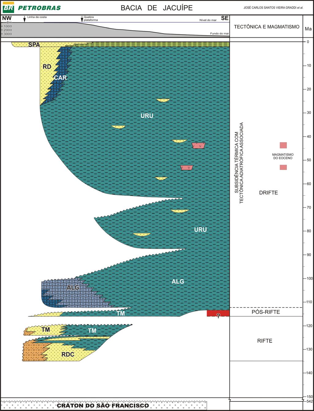
82 80
Homogeneiza<; lo da Cartografia Geol6gica do Cenoz6ico da, Area Metropolitana de Lisboa (AML)
") Comunica~oes Geologicas, 2009, t. 96, pp. 39-50 Homogeneiza
Comunica~oes Geologicas, 2009, t. 96, pp. 39-50 Homogeneiza
Lucas de Assis Soares, Luisa Nunes Ramaldes, Taciana Toledo de Almeida Albuquerque, Neyval Costa Reis Junior. São Paulo, 2013
 COMPARATIVE STUDY OF THE ATMOSPHERIC DISPERSION MODELS AND THROUGH THE ANALYSIS OF AIR QUALITY IN THE METROPOLITAN REGION OF GRANDE VITÓRIA Lucas de Assis Soares, Luisa Nunes Ramaldes, Taciana Toledo de
Manifestações magmáticas na parte sul da Bacia de Campos (Área de Cabo Frio) e na Bacia de Jequitinhonha
 e na Bacia de Jequitinhonha") Manifestações magmáticas na parte sul da Bacia de Campos (Área de Cabo Frio) e na Bacia de Jequitinhonha Magmatic occurrences in the southern part of the Campos Basin (Cabo Frio Area) and in the Jequitinhonha
Manifestações magmáticas na parte sul da Bacia de Campos (Área de Cabo Frio) e na Bacia de Jequitinhonha Magmatic occurrences in the southern part of the Campos Basin (Cabo Frio Area) and in the Jequitinhonha
ANÁLISE ESTRATIGRÁFICA DE BACIAS RIFT UMA ABORDAGEM GENÉTICA NA BACIA DE CAMAMU-ALMADA, BRASIL
 Copyright 2004, Instituto Brasileiro de Petróleo e Gás - IBP Este Trabalho Técnico Científico foi preparado para apresentação no 3 Congresso Brasileiro de P&D em Petróleo e Gás, a ser realizado no período
Immobilized Volume Reduction in Pontoon Type Floating Roof for Petroleum Tank
 Immobilized Volume Reduction in Pontoon Type Floating Roof for Petroleum Tank Florianópolis/SC November 2012 Foreword External floating roof was created in 1923 for: o Control of evaporative emissions;
Service quality in restaurants: an experimental analysis performed in Brazil
 . XIII INTERNATIONAL CONFERENCE ON INDUSTRIAL ENGINEERING AND OPERATIONS MANAGEMENT Energy that moves production: a dialogue among integration, project and sustainability 09-11 October 2007 Service quality
MASTER S DEGREE IN INTELLECTUAL PROPERTY ADMISSION EXAM
 CADERNO DE QUESTÕES NOTA FINAL MASTER S DEGREE IN INTELLECTUAL PROPERTY ADMISSION EXAM Before reading the text, pay attention to these important and essential remarks. All the answers must be written in
Um olhar que cura: Terapia das doenças espirituais (Portuguese Edition)
") Um olhar que cura: Terapia das doenças espirituais (Portuguese Edition) Padre Paulo Ricardo Click here if your download doesn"t start automatically Um olhar que cura: Terapia das doenças espirituais (Portuguese
Um olhar que cura: Terapia das doenças espirituais (Portuguese Edition) Padre Paulo Ricardo Click here if your download doesn"t start automatically Um olhar que cura: Terapia das doenças espirituais (Portuguese
Vaporpunk - A fazenda-relógio (Portuguese Edition)
") Vaporpunk - A fazenda-relógio (Portuguese Edition) Octavio Aragão Click here if your download doesn"t start automatically Vaporpunk - A fazenda-relógio (Portuguese Edition) Octavio Aragão Vaporpunk - A
Vaporpunk - A fazenda-relógio (Portuguese Edition) Octavio Aragão Click here if your download doesn"t start automatically Vaporpunk - A fazenda-relógio (Portuguese Edition) Octavio Aragão Vaporpunk - A
Vendors Enquiries for RFP 003/2015
 Date: 22/10/2015 Vendors Enquiries for RFP 003/2015 1) Question I am afraid the terms of the RFP cannot be complied by none of the companies we work with, the terms have limited the underwriters ability
Uma solução possível para garantir, em ambiente APEX, a consistência duma estrutura ISA total e disjuntiva.
 Uma solução possível para garantir, em ambiente APEX, a consistência duma estrutura ISA total e disjuntiva. A possible solution to ensure, in APEX environment, the consistency of a total and disjunctive
CORRELAÇÃO SISMOESTRATIGRÁFICA ENTRE AS BACIAS DO RECÔNCAVO E DE CAMAMU
 CORRELAÇÃO SISMOESTRATIGRÁFICA ENTRE AS BACIAS DO RECÔNCAVO E DE CAMAMU SEISMOSTRATIGRAPHYC CORRELATION BETWEEN RECÔNCAVO AND CAMAMU BASINS Daniel Bono Ribeiro VILAS BOAS 1, Paulo Augusto Vidigal Duarte
VGM. VGM information. ALIANÇA VGM WEB PORTAL USER GUIDE June 2016
 Overview The Aliança VGM Web portal is an application that enables you to submit VGM information directly to Aliança via our e-portal Web page. You can choose to enter VGM information directly, or to download
Morfologia do Perfil Praial, Sedimentologia e Evolução Histórica da Linha de Costa das Praias da Enseada do Itapocorói Santa Catarina
 UNIVERSIDADE DO VALE DO ITAJAÍ MESTRADO EM CIÊNCIA E TECNOLOGIA AMBIENTAL Morfologia do Perfil Praial, Sedimentologia e Evolução Histórica da Linha de Costa das Praias da Enseada do Itapocorói Santa Catarina
UNIVERSIDADE FEDERAL DO PARÁ INSTITUTO DE GEOCIÊNCIAS PROGRAMA DE PÓS-GRADUAÇÃO EM GEOLOGIA E GEOQUÍMICA TESE DE DOUTORADO
 UNIVERSIDADE FEDERAL DO PARÁ INSTITUTO DE GEOCIÊNCIAS PROGRAMA DE PÓS-GRADUAÇÃO EM GEOLOGIA E GEOQUÍMICA TESE DE DOUTORADO FÁCIES DEPOSICIONAIS, ESTRATIGRAFIA E ASPECTOS ESTRUTURAIS DA COBERTURA SEDIMENTAR
CENTRAL COMISSION FOR THE NAVIGATION OF THE RHINE
 CENTRAL COMISSION FOR THE NAVIGATION OF THE RHINE INLAND WATERWAY TRANSPORT IN TIMES OF GLOBALISATION PREPARATORY WORKSHOP AND SIDE EVENT PARAGUAY PARANÁ INLAND WATERWAY MARSEILLE (France), 13 MARCH 2012
Mathematical Foundation I: Fourier Transform, Bandwidth, and Band-pass Signal Representation PROF. MICHAEL TSAI 2011/10/13
 Mathematical Foundation I: Fourier Transform, Bandwidth, and Band-pass Signal Representation PROF. MICHAEL TSAI 2011/10/13 Fourier Transform (): a non-periodic deterministic signal. Definition: the Fourier
O PRíNCIPE FELIZ E OUTRAS HISTóRIAS (EDIçãO BILíNGUE) (PORTUGUESE EDITION) BY OSCAR WILDE
 (PORTUGUESE EDITION) BY OSCAR WILDE") Read Online and Download Ebook O PRíNCIPE FELIZ E OUTRAS HISTóRIAS (EDIçãO BILíNGUE) (PORTUGUESE EDITION) BY OSCAR WILDE DOWNLOAD EBOOK : O PRíNCIPE FELIZ E OUTRAS HISTóRIAS (EDIçãO Click link bellow and
Read Online and Download Ebook O PRíNCIPE FELIZ E OUTRAS HISTóRIAS (EDIçãO BILíNGUE) (PORTUGUESE EDITION) BY OSCAR WILDE DOWNLOAD EBOOK : O PRíNCIPE FELIZ E OUTRAS HISTóRIAS (EDIçãO Click link bellow and
DEPARTAMENTO DE ENGENHARIA CIVIL E ARQUITETURA
 SCHOOL YEAR 01/013 1 ST EXAM 013/01/16 08h00 DURATION: h00 THEORY QUESTIONS (maximum 45 minutes) 1. In a pumped trunk main system explain why the smallest technically viable diameter may not be the least
ESCOLA NAVAL DEPARTAMENTO DE MARINHA
 ESCOLA NAVAL DEPARTAMENTO DE MARINHA CIÊNCIA E TÉCNICA NOS ANAIS DO CLUBE MILITAR NAVAL DA FUNDAÇÃO ATÉ 1879 ASPOF Rui Miguel David Coronha MESTRADO EM CIÊNCIAS MILITARES NAVAIS (MARINHA) 2013 ESCOLA NAVAL
MySQL: Comece com o principal banco de dados open source do mercado (Portuguese Edition)
") MySQL: Comece com o principal banco de dados open source do mercado (Portuguese Edition) Click here if your download doesn"t start automatically MySQL: Comece com o principal banco de dados open source
MySQL: Comece com o principal banco de dados open source do mercado (Portuguese Edition) Click here if your download doesn"t start automatically MySQL: Comece com o principal banco de dados open source
Comportamento Organizacional: O Comportamento Humano no Trabalho (Portuguese Edition)
") Comportamento Organizacional: O Comportamento Humano no Trabalho (Portuguese Edition) John W. Newstrom Click here if your download doesn"t start automatically Comportamento Organizacional: O Comportamento
Comportamento Organizacional: O Comportamento Humano no Trabalho (Portuguese Edition) John W. Newstrom Click here if your download doesn"t start automatically Comportamento Organizacional: O Comportamento
Direito Processual Civil (Coleção Sucesso Concursos Públicos e OAB) (Portuguese Edition)
 (Portuguese Edition)") Direito Processual Civil (Coleção Sucesso Concursos Públicos e OAB) (Portuguese Edition) Marina Vezzoni Click here if your download doesn"t start automatically Direito Processual Civil (Coleção Sucesso
Direito Processual Civil (Coleção Sucesso Concursos Públicos e OAB) (Portuguese Edition) Marina Vezzoni Click here if your download doesn"t start automatically Direito Processual Civil (Coleção Sucesso
Pesquisa Qualitativa do Início ao Fim (Métodos de Pesquisa) (Portuguese Edition)
 (Portuguese Edition)") Pesquisa Qualitativa do Início ao Fim (Métodos de Pesquisa) (Portuguese Edition) Robert K. Yin Click here if your download doesn"t start automatically Pesquisa Qualitativa do Início ao Fim (Métodos de
Pesquisa Qualitativa do Início ao Fim (Métodos de Pesquisa) (Portuguese Edition) Robert K. Yin Click here if your download doesn"t start automatically Pesquisa Qualitativa do Início ao Fim (Métodos de
Farmacologia na Pratica de Enfermagem (Em Portuguese do Brasil)
") Farmacologia na Pratica de Enfermagem (Em Portuguese do Brasil) Click here if your download doesn"t start automatically Farmacologia na Pratica de Enfermagem (Em Portuguese do Brasil) Farmacologia na Pratica
Farmacologia na Pratica de Enfermagem (Em Portuguese do Brasil) Click here if your download doesn"t start automatically Farmacologia na Pratica de Enfermagem (Em Portuguese do Brasil) Farmacologia na Pratica
Aspectos Multidisciplinares das Artes Marciais: 1 (Portuguese Edition)
") Aspectos Multidisciplinares das Artes Marciais: 1 (Portuguese Edition) Marcelo Moreira Antunes (org.) Click here if your download doesn"t start automatically Aspectos Multidisciplinares das Artes Marciais:
Aspectos Multidisciplinares das Artes Marciais: 1 (Portuguese Edition) Marcelo Moreira Antunes (org.) Click here if your download doesn"t start automatically Aspectos Multidisciplinares das Artes Marciais:
ATLAS DE ACUPUNTURA VETERINáRIA. CãES E GATOS (EM PORTUGUESE DO BRASIL) BY CHOO HYUNG KIM
 BY CHOO HYUNG KIM") Read Online and Download Ebook ATLAS DE ACUPUNTURA VETERINáRIA. CãES E GATOS (EM PORTUGUESE DO BRASIL) BY CHOO HYUNG KIM DOWNLOAD EBOOK : ATLAS DE ACUPUNTURA VETERINáRIA. CãES E GATOS Click link bellow
Read Online and Download Ebook ATLAS DE ACUPUNTURA VETERINáRIA. CãES E GATOS (EM PORTUGUESE DO BRASIL) BY CHOO HYUNG KIM DOWNLOAD EBOOK : ATLAS DE ACUPUNTURA VETERINáRIA. CãES E GATOS Click link bellow
Prova de Seleção Mestrado LINGUA INGLESA 15/02/2016
 Prova de Seleção Mestrado LINGUA INGLESA 15/02/2016 Instruções aos candidatos: (1) Preencher somente o número de inscrição em todas as folhas. (2) Usar caneta preta ou azul. 1 2 3 4 5 6 7 8 9 10 11 12
Introdução A Delphi Com Banco De Dados Firebird (Portuguese Edition)
") Introdução A Delphi Com Banco De Dados Firebird (Portuguese Edition) Ricardo De Moraes / André Luís De Souza Silva Click here if your download doesn"t start automatically Introdução A Delphi Com Banco
Introdução A Delphi Com Banco De Dados Firebird (Portuguese Edition) Ricardo De Moraes / André Luís De Souza Silva Click here if your download doesn"t start automatically Introdução A Delphi Com Banco
Como escrever para o Enem: roteiro para uma redação nota (Portuguese Edition)
") Como escrever para o Enem: roteiro para uma redação nota 1.000 (Portuguese Edition) Arlete Salvador Click here if your download doesn"t start automatically Como escrever para o Enem: roteiro para uma redação
Como escrever para o Enem: roteiro para uma redação nota 1.000 (Portuguese Edition) Arlete Salvador Click here if your download doesn"t start automatically Como escrever para o Enem: roteiro para uma redação
Da Emoção à Lesão: um Guia de Medicina Psicossomática (Portuguese Edition)
") Da Emoção à Lesão: um Guia de Medicina Psicossomática (Portuguese Edition) Geraldo José Ballone, Ida Vani Ortolani, Eurico Pereira Neto Click here if your download doesn"t start automatically Download
Da Emoção à Lesão: um Guia de Medicina Psicossomática (Portuguese Edition) Geraldo José Ballone, Ida Vani Ortolani, Eurico Pereira Neto Click here if your download doesn"t start automatically Download
Guia para Formacao de Analistas de Processos: Gestão Por Processos de Forma Simples (Portuguese Edition)
") Guia para Formacao de Analistas de Processos: Gestão Por Processos de Forma Simples (Portuguese Edition) Mr. Gart Capote Click here if your download doesn"t start automatically Guia para Formacao de Analistas
Guia para Formacao de Analistas de Processos: Gestão Por Processos de Forma Simples (Portuguese Edition) Mr. Gart Capote Click here if your download doesn"t start automatically Guia para Formacao de Analistas
Princípios de Direito Previdenciário (Portuguese Edition)
") Princípios de Direito Previdenciário (Portuguese Edition) Wladimir Novaes. Martinez Click here if your download doesn"t start automatically Princípios de Direito Previdenciário (Portuguese Edition) Wladimir
Princípios de Direito Previdenciário (Portuguese Edition) Wladimir Novaes. Martinez Click here if your download doesn"t start automatically Princípios de Direito Previdenciário (Portuguese Edition) Wladimir
GERENCIAMENTO DA ROTINA DO TRABALHO DO DIA-A-DIA (EM PORTUGUESE DO BRASIL) BY VICENTE FALCONI
 BY VICENTE FALCONI") Read Online and Download Ebook GERENCIAMENTO DA ROTINA DO TRABALHO DO DIA-A-DIA (EM PORTUGUESE DO BRASIL) BY VICENTE FALCONI DOWNLOAD EBOOK : GERENCIAMENTO DA ROTINA DO TRABALHO DO DIA-A- Click link bellow
Read Online and Download Ebook GERENCIAMENTO DA ROTINA DO TRABALHO DO DIA-A-DIA (EM PORTUGUESE DO BRASIL) BY VICENTE FALCONI DOWNLOAD EBOOK : GERENCIAMENTO DA ROTINA DO TRABALHO DO DIA-A- Click link bellow
TDD Desenvolvimento Guiado por Testes (Portuguese Edition)
") TDD Desenvolvimento Guiado por Testes (Portuguese Edition) Kent Beck Click here if your download doesn"t start automatically TDD Desenvolvimento Guiado por Testes (Portuguese Edition) Kent Beck TDD Desenvolvimento
TDD Desenvolvimento Guiado por Testes (Portuguese Edition) Kent Beck Click here if your download doesn"t start automatically TDD Desenvolvimento Guiado por Testes (Portuguese Edition) Kent Beck TDD Desenvolvimento
Palavras chave: trabalho colaborativo, desenvolvimento profissional, articulação curricular, tarefas de investigação e exploração.
 RESUMO Esta investigação, tem como objectivo perceber como é que o trabalho colaborativo pode ajudar a melhorar as práticas lectivas dos professores, favorecendo a articulação curricular entre ciclos na
UPGRADE Engineering Bulletin Dec 02
 MVA Series UPGRADE Engineering Bulletin Dec 0 MVA Surface Mount High CV Vertical Chip Solvent Proof (-6V) 85 C Maximum Temperature Actual Size The MVA series is a general purpose 85 C surface mount capacitor
Como Falar no Rádio - Prática de Locução Am e Fm (Portuguese Edition)
") Como Falar no Rádio - Prática de Locução Am e Fm (Portuguese Edition) Cyro César Click here if your download doesn"t start automatically Como Falar no Rádio - Prática de Locução Am e Fm (Portuguese Edition)
Como Falar no Rádio - Prática de Locução Am e Fm (Portuguese Edition) Cyro César Click here if your download doesn"t start automatically Como Falar no Rádio - Prática de Locução Am e Fm (Portuguese Edition)
Rádio Escolar: uma experiência de letramento midiático (Coleção Trabalhando com... na escola Livro 4) (Portuguese Edition)
 (Portuguese Edition)") Rádio Escolar: uma experiência de letramento midiático (Coleção Trabalhando com... na escola Livro 4) (Portuguese Edition) Marcos Baltar Click here if your download doesn"t start automatically Rádio Escolar:
Rádio Escolar: uma experiência de letramento midiático (Coleção Trabalhando com... na escola Livro 4) (Portuguese Edition) Marcos Baltar Click here if your download doesn"t start automatically Rádio Escolar:
A Avaliação dos Projetos
 A Avaliação dos Projetos Luis M. Correia 1 Instituto Superior Técnico / INOV-INESC Universidade de Lisboa, Portugal As Perguntas Como são avaliadas as propostas? Quem avalia as propostas? Quais os critérios
Abraçado pelo Espírito (Portuguese Edition)
") Abraçado pelo Espírito (Portuguese Edition) Charles Swindoll Click here if your download doesn"t start automatically Abraçado pelo Espírito (Portuguese Edition) Charles Swindoll Abraçado pelo Espírito
Abraçado pelo Espírito (Portuguese Edition) Charles Swindoll Click here if your download doesn"t start automatically Abraçado pelo Espírito (Portuguese Edition) Charles Swindoll Abraçado pelo Espírito
Statistical analysis of unconventional bituminous mixtures performance based on 4PB Tests
 Grupo de Investigação em Vias de Comunicação Statistical analysis of unconventional bituminous mixtures performance based on 4PB Tests PORTUGAL Silvino Capitão António Baptista Luís Picado-Santos ISEC
Pesquisa Qualitativa do Início ao Fim (Métodos de Pesquisa) (Portuguese Edition)
 (Portuguese Edition)") Pesquisa Qualitativa do Início ao Fim (Métodos de Pesquisa) (Portuguese Edition) Robert K. Yin Click here if your download doesn"t start automatically Pesquisa Qualitativa do Início ao Fim (Métodos de
Pesquisa Qualitativa do Início ao Fim (Métodos de Pesquisa) (Portuguese Edition) Robert K. Yin Click here if your download doesn"t start automatically Pesquisa Qualitativa do Início ao Fim (Métodos de
Técnicas para Detecção de Danos pelo Hidrogênio
 Fórum Técnico Deterioração pelo Hidrogênio. Técnicas para Detecção de Danos pelo Hidrogênio JMA Rebello Universidade Federal do Rio de Janeiro Main Objectives The objective of this work is to present some
A ENTREVISTA COMPREENSIVA: UM GUIA PARA PESQUISA DE CAMPO (PORTUGUESE EDITION) BY JEAN-CLAUDE KAUFMANN
 BY JEAN-CLAUDE KAUFMANN") Read Online and Download Ebook A ENTREVISTA COMPREENSIVA: UM GUIA PARA PESQUISA DE CAMPO (PORTUGUESE EDITION) BY JEAN-CLAUDE KAUFMANN DOWNLOAD EBOOK : A ENTREVISTA COMPREENSIVA: UM GUIA PARA CLAUDE KAUFMANN
Read Online and Download Ebook A ENTREVISTA COMPREENSIVA: UM GUIA PARA PESQUISA DE CAMPO (PORTUGUESE EDITION) BY JEAN-CLAUDE KAUFMANN DOWNLOAD EBOOK : A ENTREVISTA COMPREENSIVA: UM GUIA PARA CLAUDE KAUFMANN
CIS 500 Software Foundations Fall September(continued) IS 500, 8 September(continued) 1
 IS 500, 8 September(continued) 1") CIS 500 Software Foundations Fall 2003 8 September(continued) IS 500, 8 September(continued) 1 Polymorphism This version of issaidtobepolymorphic,becauseitcanbeapplied to many different types of arguments.
CIS 500 Software Foundations Fall 2003 8 September(continued) IS 500, 8 September(continued) 1 Polymorphism This version of issaidtobepolymorphic,becauseitcanbeapplied to many different types of arguments.
Poder sem limites - o caminho do sucesso pessoal pela programação neurolinguística
 Poder sem limites - o caminho do sucesso pessoal pela programação neurolinguística Anthony Robbins Click here if your download doesn"t start automatically Poder sem limites - o caminho do sucesso pessoal
Meditacao da Luz: O Caminho da Simplicidade
 Meditacao da Luz: O Caminho da Simplicidade Leonardo Boff Click here if your download doesn"t start automatically Meditacao da Luz: O Caminho da Simplicidade Leonardo Boff Meditacao da Luz: O Caminho da
Artigos de dados. Publicação de dados de biodiversidade através do GBIF. Rui Figueira. Curso de formação :
 Artigos de dados Curso de formação : Publicação de dados de biodiversidade através do GBIF Rui Figueira ruifigueira@isa.ulisboa.pt Nó Português do GBIF, Instituto Superior de Agronomia, Universidade de
Planejamento de comunicação integrada (Portuguese Edition)
") Planejamento de comunicação integrada (Portuguese Edition) Click here if your download doesn"t start automatically Planejamento de comunicação integrada (Portuguese Edition) Planejamento de comunicação
Planejamento de comunicação integrada (Portuguese Edition) Click here if your download doesn"t start automatically Planejamento de comunicação integrada (Portuguese Edition) Planejamento de comunicação
Introdução A Delphi Com Banco De Dados Firebird (Portuguese Edition)
") Introdução A Delphi Com Banco De Dados Firebird (Portuguese Edition) Ricardo De Moraes / André Luís De Souza Silva Click here if your download doesn"t start automatically Introdução A Delphi Com Banco
Introdução A Delphi Com Banco De Dados Firebird (Portuguese Edition) Ricardo De Moraes / André Luís De Souza Silva Click here if your download doesn"t start automatically Introdução A Delphi Com Banco
DISSERTAÇÃO DE MESTRADO Nº 476 PALINOLOGIA DA FORMAÇÃO PIRABAS, NOS MUNICÍPIOS DE PRIMAVERA E SALINÓPOLIS, NORDESTE DO ESTADO DO PARÁ, BRASIL
 UNIVERSIDADE FEDERAL DO PARÁ INSTITUTO DE GEOCIÊNCIAS PROGRAMA DE PÓS-GRADUAÇÃO EM GEOLOGIA E GEOQUÍMICA DISSERTAÇÃO DE MESTRADO Nº 476 PALINOLOGIA DA FORMAÇÃO PIRABAS, NOS MUNICÍPIOS DE PRIMAVERA E SALINÓPOLIS,
Dermatologia Clínica. Guia Colorido Para Diagnostico e Tratamento (Em Portuguese do Brasil)
") Dermatologia Clínica. Guia Colorido Para Diagnostico e Tratamento (Em Portuguese do Brasil) Click here if your download doesn"t start automatically Dermatologia Clínica. Guia Colorido Para Diagnostico
Dermatologia Clínica. Guia Colorido Para Diagnostico e Tratamento (Em Portuguese do Brasil) Click here if your download doesn"t start automatically Dermatologia Clínica. Guia Colorido Para Diagnostico
As 100 melhores piadas de todos os tempos (Portuguese Edition)
") As 100 melhores piadas de todos os tempos (Portuguese Edition) Click here if your download doesn"t start automatically As 100 melhores piadas de todos os tempos (Portuguese Edition) As 100 melhores piadas
As 100 melhores piadas de todos os tempos (Portuguese Edition) Click here if your download doesn"t start automatically As 100 melhores piadas de todos os tempos (Portuguese Edition) As 100 melhores piadas
PL/SQL: Domine a linguagem do banco de dados Oracle (Portuguese Edition)
") PL/SQL: Domine a linguagem do banco de dados Oracle (Portuguese Edition) Eduardo Gonçalves Click here if your download doesn"t start automatically PL/SQL: Domine a linguagem do banco de dados Oracle (Portuguese
PL/SQL: Domine a linguagem do banco de dados Oracle (Portuguese Edition) Eduardo Gonçalves Click here if your download doesn"t start automatically PL/SQL: Domine a linguagem do banco de dados Oracle (Portuguese
Ganhar Dinheiro Em Network Marketing (Portuguese Edition)
") Ganhar Dinheiro Em Network Marketing (Portuguese Edition) Click here if your download doesn"t start automatically Ganhar Dinheiro Em Network Marketing (Portuguese Edition) Ganhar Dinheiro Em Network Marketing
Ganhar Dinheiro Em Network Marketing (Portuguese Edition) Click here if your download doesn"t start automatically Ganhar Dinheiro Em Network Marketing (Portuguese Edition) Ganhar Dinheiro Em Network Marketing
Livro do Desassossego
 Livro do Desassossego Fernando Pessoa Click here if your download doesn"t start automatically Livro do Desassossego Fernando Pessoa Livro do Desassossego Fernando Pessoa [...] Download Livro do Desassossego...pdf
Transformando Pessoas - Coaching, PNL e Simplicidade no processo de mudancas (Portuguese Edition)
") Transformando Pessoas - Coaching, PNL e Simplicidade no processo de mudancas (Portuguese Edition) Felippe / Marcelo Click here if your download doesn"t start automatically Transformando Pessoas - Coaching,
Transformando Pessoas - Coaching, PNL e Simplicidade no processo de mudancas (Portuguese Edition) Felippe / Marcelo Click here if your download doesn"t start automatically Transformando Pessoas - Coaching,
Antonio Moreira Franco Junior. Click here if your download doesn"t start automatically
 Ensino da Contabilidade Introdutória: Uma análise do ensino nos cursos de Ciências Contábeis das Instituições de Ensino Superior do Estado de São Paulo (Portuguese Edition) Antonio Moreira Franco Junior
Dermatologia Clínica. Guia Colorido Para Diagnostico e Tratamento (Em Portuguese do Brasil)
") Dermatologia Clínica. Guia Colorido Para Diagnostico e Tratamento (Em Portuguese do Brasil) Click here if your download doesn"t start automatically Dermatologia Clínica. Guia Colorido Para Diagnostico
Dermatologia Clínica. Guia Colorido Para Diagnostico e Tratamento (Em Portuguese do Brasil) Click here if your download doesn"t start automatically Dermatologia Clínica. Guia Colorido Para Diagnostico
TEN CATE. HISTOLOGIA ORAL (EM PORTUGUESE DO BRASIL) BY ANTONIO NANCI
 BY ANTONIO NANCI") Read Online and Download Ebook TEN CATE. HISTOLOGIA ORAL (EM PORTUGUESE DO BRASIL) BY ANTONIO NANCI DOWNLOAD EBOOK : TEN CATE. HISTOLOGIA ORAL (EM PORTUGUESE DO Click link bellow and free register to download
Read Online and Download Ebook TEN CATE. HISTOLOGIA ORAL (EM PORTUGUESE DO BRASIL) BY ANTONIO NANCI DOWNLOAD EBOOK : TEN CATE. HISTOLOGIA ORAL (EM PORTUGUESE DO Click link bellow and free register to download
DISCIPLINA: INTERPRETAÇÃO SÍSMICA APLICADA À EXPLORAÇÃO DE PETRÓLEO (3 CRÉDITOS)
") DISCIPLINA: INTERPRETAÇÃO SÍSMICA APLICADA À EXPLORAÇÃO DE PETRÓLEO (3 CRÉDITOS) Objetivos: Apresentar os fluxos de trabalho e metodologias utilizadas na indústria de exploração do petróleo. Proporcionar
DISCIPLINA: INTERPRETAÇÃO SÍSMICA APLICADA À EXPLORAÇÃO DE PETRÓLEO (3 CRÉDITOS) Objetivos: Apresentar os fluxos de trabalho e metodologias utilizadas na indústria de exploração do petróleo. Proporcionar
xadrez de 120 minutos, um espectador, na terra, dirá que o jogo demorou 200 minutos. 1. O que acontece aqui?
 1 xadrez de 120 minutos, um espectador, na terra, dirá que o jogo demorou 200 minutos. 1. O que acontece aqui? 20 anos V = 0.8c 12 anos 12 anos a afastar e 12 anos a aproximar 20 anos 12 anos Dois gémeos
A ENTREVISTA COMPREENSIVA: UM GUIA PARA PESQUISA DE CAMPO (PORTUGUESE EDITION) BY JEAN-CLAUDE KAUFMANN
 BY JEAN-CLAUDE KAUFMANN") Read Online and Download Ebook A ENTREVISTA COMPREENSIVA: UM GUIA PARA PESQUISA DE CAMPO (PORTUGUESE EDITION) BY JEAN-CLAUDE KAUFMANN DOWNLOAD EBOOK : A ENTREVISTA COMPREENSIVA: UM GUIA PARA CLAUDE KAUFMANN
Read Online and Download Ebook A ENTREVISTA COMPREENSIVA: UM GUIA PARA PESQUISA DE CAMPO (PORTUGUESE EDITION) BY JEAN-CLAUDE KAUFMANN DOWNLOAD EBOOK : A ENTREVISTA COMPREENSIVA: UM GUIA PARA CLAUDE KAUFMANN
Gestão da comunicação - Epistemologia e pesquisa teórica (Portuguese Edition)
") Gestão da comunicação - Epistemologia e pesquisa teórica (Portuguese Edition) Maria Cristina Castilho Costa, Maria Aparecida Baccega Click here if your download doesn"t start automatically Download and
Gestão da comunicação - Epistemologia e pesquisa teórica (Portuguese Edition) Maria Cristina Castilho Costa, Maria Aparecida Baccega Click here if your download doesn"t start automatically Download and
Astrologia, Psicologia e os Quatro Elementos (Portuguese Edition)
") Astrologia, Psicologia e os Quatro Elementos (Portuguese Edition) Click here if your download doesn"t start automatically Astrologia, Psicologia e os Quatro Elementos (Portuguese Edition) Astrologia, Psicologia
Astrologia, Psicologia e os Quatro Elementos (Portuguese Edition) Click here if your download doesn"t start automatically Astrologia, Psicologia e os Quatro Elementos (Portuguese Edition) Astrologia, Psicologia
MAPEAMENTO ESTRATIGRÁFICO DE BACIAS RIFTE A PARTIR DE PADRÕES DE EMPILHAMENTO E SEUS SIGNIFICADOS GENÉTICOS
 4 o PDPETRO, Campinas, SP 1.1.0097-1 1 MAPEAMENTO ESTRATIGRÁFICO DE BACIAS RIFTE A PARTIR DE PADRÕES DE EMPILHAMENTO E SEUS SIGNIFICADOS GENÉTICOS Juliano Kuchle (UFRGS/ANP-PRH12), Michael Holz (IG-UFRGS),
TDD Desenvolvimento Guiado por Testes (Portuguese Edition)
") TDD Desenvolvimento Guiado por Testes (Portuguese Edition) Kent Beck Click here if your download doesn"t start automatically TDD Desenvolvimento Guiado por Testes (Portuguese Edition) Kent Beck TDD Desenvolvimento
TDD Desenvolvimento Guiado por Testes (Portuguese Edition) Kent Beck Click here if your download doesn"t start automatically TDD Desenvolvimento Guiado por Testes (Portuguese Edition) Kent Beck TDD Desenvolvimento
GERENCIAMENTO PELAS DIRETRIZES (PORTUGUESE EDITION) BY VICENTE FALCONI
 BY VICENTE FALCONI") Read Online and Download Ebook GERENCIAMENTO PELAS DIRETRIZES (PORTUGUESE EDITION) BY VICENTE FALCONI DOWNLOAD EBOOK : GERENCIAMENTO PELAS DIRETRIZES (PORTUGUESE Click link bellow and free register to
Read Online and Download Ebook GERENCIAMENTO PELAS DIRETRIZES (PORTUGUESE EDITION) BY VICENTE FALCONI DOWNLOAD EBOOK : GERENCIAMENTO PELAS DIRETRIZES (PORTUGUESE Click link bellow and free register to
Aula 3 - Famílias lógicas
 Aula 3 - Famílias lógicas Prof. Renan Sebem Disciplina de Eletrônica Digital Graduação em Engenharia Elétrica Universidade do Estado de Santa Catarina Joinville-SC Brasil 1 de março de 2016 ELD0001 Prof.
CARACTERIZAÇÃO E GÊNESE DO ADENSAMENTO SUBSUPERFICIAL EM SOLOS DE TABULEIRO DO SEMI-ÁRIDO DO NORDESTE DO BRASIL MARIA SONIA LOPES DA SILVA
 CARACTERIZAÇÃO E GÊNESE DO ADENSAMENTO SUBSUPERFICIAL EM SOLOS DE TABULEIRO DO SEMI-ÁRIDO DO NORDESTE DO BRASIL MARIA SONIA LOPES DA SILVA (Engenheira Agrônoma, UFAL) CARACTERIZAÇÃO E GÊNESE DO ADENSAMENTO
ATLAS COLORIDO DE ANATOMIA VETERINáRIA DE EQUINOS (EM PORTUGUESE DO BRASIL) BY STANLEY H. ASHDOWN RAYMOND R. DONE
 BY STANLEY H. ASHDOWN RAYMOND R. DONE") Read Online and Download Ebook ATLAS COLORIDO DE ANATOMIA VETERINáRIA DE EQUINOS (EM PORTUGUESE DO BRASIL) BY STANLEY H. ASHDOWN RAYMOND R. DONE DOWNLOAD EBOOK : ATLAS COLORIDO DE ANATOMIA VETERINáRIA
Read Online and Download Ebook ATLAS COLORIDO DE ANATOMIA VETERINáRIA DE EQUINOS (EM PORTUGUESE DO BRASIL) BY STANLEY H. ASHDOWN RAYMOND R. DONE DOWNLOAD EBOOK : ATLAS COLORIDO DE ANATOMIA VETERINáRIA
Poder sem limites - o caminho do sucesso pessoal pela programação neurolinguística
 Poder sem limites - o caminho do sucesso pessoal pela programação neurolinguística By Anthony Robbins Poder sem limites - o caminho do sucesso pessoal pela programação neurolinguística By Anthony Robbins
Renato Almeida. Deltas
 Deltas Deltas Definição: Delta: protuberância na costa de mares, lagunas, baías ou lagos formada pelo acúmulo de sedimentos trazidos por um rio. Os deltas se formam quando o suprimento de sedimentos fluviais
OpenStereo: open source, cross-platform software for structural geology analysis
 OpenStereo: open source, cross-platform software for structural geology analysis Carlos Henrique Grohmann & Ginaldo A.C. Campanha guano@usp.br Institute of Geosciences, University of São Paulo, Brazil
Aquecimento global Rise of temperature
 Aquecimento global Rise of temperature Drop by drop. Comenius project What is Global warming? Aquecimento global é o aumento da temperatura média dos oceanos e do ar perto da superfície da Terra ocorrido
FCL Capital March 2019
 Performance FCL Hedge First Quarter 2019 6,48% First Quarter 2019 % CDI 428,76% Since Inception 13,16% Annualized since inception 5,86% FCL Opportunities First quarter 2019 in BRL 24,63% First quarter
Pesquisa de Marketing: Uma Orientação Aplicada (Portuguese Edition)
") Pesquisa de Marketing: Uma Orientação Aplicada (Portuguese Edition) By Naresh K. Malhotra Pesquisa de Marketing: Uma Orientação Aplicada (Portuguese Edition) By Naresh K. Malhotra Ilustra a interação entre
Pesquisa de Marketing: Uma Orientação Aplicada (Portuguese Edition) By Naresh K. Malhotra Pesquisa de Marketing: Uma Orientação Aplicada (Portuguese Edition) By Naresh K. Malhotra Ilustra a interação entre
Energia dos Chakras, Saúde e Autotransformação (Portuguese Edition)
") Energia dos Chakras, Saúde e Autotransformação (Portuguese Edition) Alírio de Cerqueira Filho Click here if your download doesn"t start automatically Energia dos Chakras, Saúde e Autotransformação (Portuguese
Energia dos Chakras, Saúde e Autotransformação (Portuguese Edition) Alírio de Cerqueira Filho Click here if your download doesn"t start automatically Energia dos Chakras, Saúde e Autotransformação (Portuguese
Certificação PMP: Alinhado com o PMBOK Guide 5ª edição (Portuguese Edition)
") Certificação PMP: Alinhado com o PMBOK Guide 5ª edição (Portuguese Edition) Armando Monteiro Click here if your download doesn"t start automatically Certificação PMP: Alinhado com o PMBOK Guide 5ª edição
Certificação PMP: Alinhado com o PMBOK Guide 5ª edição (Portuguese Edition) Armando Monteiro Click here if your download doesn"t start automatically Certificação PMP: Alinhado com o PMBOK Guide 5ª edição
Bíblia de Estudo Conselheira - Gênesis: Acolhimento Reflexão Graça (Portuguese Edition)
") Bíblia de Estudo Conselheira - Gênesis: Acolhimento Reflexão Graça (Portuguese Edition) Sociedade Bíblica do Brasil Click here if your download doesn"t start automatically Download and Read Free Online
Bíblia de Estudo Conselheira - Gênesis: Acolhimento Reflexão Graça (Portuguese Edition) Sociedade Bíblica do Brasil Click here if your download doesn"t start automatically Download and Read Free Online
Editorial Review. Users Review
 Download and Read Free Online Java SE 8 Programmer I: O guia para sua certificação Oracle Certified Associate (Portuguese Edition) By Guilherme Silveira, Mário Amaral Editorial Review Users Review From
A dança do corpo vestido: Um estudo do desenvolvimento do figurino de balé clássico até o século XIX (Portuguese Edition)
") A dança do corpo vestido: Um estudo do desenvolvimento do figurino de balé clássico até o século XIX (Portuguese Edition) Francisca Dantas Mendes Click here if your download doesn"t start automatically
A dança do corpo vestido: Um estudo do desenvolvimento do figurino de balé clássico até o século XIX (Portuguese Edition) Francisca Dantas Mendes Click here if your download doesn"t start automatically
Scientific data repositories: the USP experience
 Scientific data repositories: the USP experience Superintendência de Tecnologia da Informação 2018 : Sylvio Canuto Antonio Mauro Saraiva Superintendência de TI: João Eduardo Ferreira Fátima L. S. Nunes
Boids Model Applied to Cell Segregation
 Boids Model Applied to Cell Segregation L G Brunnet, J Belmonti, G L Thomas, R M C de Almeida, H Chaté Instituto de Física, Univ. Federal do Rio Grande do Sul, Brasil and CEA-Saclay, France XXVIII Encontro
Inflation Expectations and Behavior: Do Survey Respondents Act on their Beliefs? O. Armantier, W. Bruine de Bruin, G. Topa W. VanderKlaauw, B.
 Inflation Expectations and Behavior: Do Survey Respondents Act on their Beliefs? O. Armantier, W. Bruine de Bruin, G. Topa W. VanderKlaauw, B. Zafar November 18, 2010 Introduction Inflation expectations
Biscuit - potes (Coleção Artesanato) (Portuguese Edition)
 (Portuguese Edition)") Biscuit - potes (Coleção Artesanato) (Portuguese Edition) Regina Panzoldo Click here if your download doesn"t start automatically Biscuit - potes (Coleção Artesanato) (Portuguese Edition) Regina Panzoldo
Biscuit - potes (Coleção Artesanato) (Portuguese Edition) Regina Panzoldo Click here if your download doesn"t start automatically Biscuit - potes (Coleção Artesanato) (Portuguese Edition) Regina Panzoldo
MANUAL PRATICO DO PLANO DE PROJETO: UTILIZANDO O PMBOK GUIDE BY RICARDO VIANA VARGAS
 Read Online and Download Ebook MANUAL PRATICO DO PLANO DE PROJETO: UTILIZANDO O PMBOK GUIDE BY RICARDO VIANA VARGAS DOWNLOAD EBOOK : MANUAL PRATICO DO PLANO DE PROJETO: UTILIZANDO Click link bellow and
Bíblia de Estudo Conselheira - Salmos: Acolhimento Reflexão Graça (Portuguese Edition)
") Bíblia de Estudo Conselheira - Salmos: Acolhimento Reflexão Graça (Portuguese Edition) Click here if your download doesn"t start automatically Bíblia de Estudo Conselheira - Salmos: Acolhimento Reflexão
Bíblia de Estudo Conselheira - Salmos: Acolhimento Reflexão Graça (Portuguese Edition) Click here if your download doesn"t start automatically Bíblia de Estudo Conselheira - Salmos: Acolhimento Reflexão
PL/SQL: Domine a linguagem do banco de dados Oracle (Portuguese Edition)
") PL/SQL: Domine a linguagem do banco de dados Oracle (Portuguese Edition) Eduardo Gonçalves Click here if your download doesn"t start automatically PL/SQL: Domine a linguagem do banco de dados Oracle (Portuguese
PL/SQL: Domine a linguagem do banco de dados Oracle (Portuguese Edition) Eduardo Gonçalves Click here if your download doesn"t start automatically PL/SQL: Domine a linguagem do banco de dados Oracle (Portuguese
daily activity into three 10-minute segments if you re having difficulty finding time to exercise.
 Atividade extra Questão 01 http://pt.wikipedia.org/wiki/gin%c3%a1stica Get more physical activity. Within two months of starting, frequent aerobic exercise can increase HDL cholesterol by about 5 percent
Iniciação à Administração Geral (Portuguese Edition)
") Iniciação à Administração Geral (Portuguese Edition) Idalberto Chiavenato Click here if your download doesn"t start automatically Iniciação à Administração Geral (Portuguese Edition) Idalberto Chiavenato
Iniciação à Administração Geral (Portuguese Edition) Idalberto Chiavenato Click here if your download doesn"t start automatically Iniciação à Administração Geral (Portuguese Edition) Idalberto Chiavenato
ATLAS DE ACUPUNTURA VETERINáRIA. CãES E GATOS (EM PORTUGUESE DO BRASIL) BY CHOO HYUNG KIM
 BY CHOO HYUNG KIM") Read Online and Download Ebook ATLAS DE ACUPUNTURA VETERINáRIA. CãES E GATOS (EM PORTUGUESE DO BRASIL) BY CHOO HYUNG KIM DOWNLOAD EBOOK : ATLAS DE ACUPUNTURA VETERINáRIA. CãES E GATOS Click link bellow
Read Online and Download Ebook ATLAS DE ACUPUNTURA VETERINáRIA. CãES E GATOS (EM PORTUGUESE DO BRASIL) BY CHOO HYUNG KIM DOWNLOAD EBOOK : ATLAS DE ACUPUNTURA VETERINáRIA. CãES E GATOS Click link bellow
ASIP Conference 2007
 Establishing Reliability of Inspection Interval for Structures Subjected to Fatigue Loads Maj ALBERTO W Mello, Ph.D Maj Abilio N GARCIA, Ph.D Maj Cesar DEMETRIO Santos, MSc ASIP Conference 2007 Establishing
GERENCIAMENTO PELAS DIRETRIZES (PORTUGUESE EDITION) BY VICENTE FALCONI
 BY VICENTE FALCONI") Read Online and Download Ebook GERENCIAMENTO PELAS DIRETRIZES (PORTUGUESE EDITION) BY VICENTE FALCONI DOWNLOAD EBOOK : GERENCIAMENTO PELAS DIRETRIZES (PORTUGUESE Click link bellow and free register to
Read Online and Download Ebook GERENCIAMENTO PELAS DIRETRIZES (PORTUGUESE EDITION) BY VICENTE FALCONI DOWNLOAD EBOOK : GERENCIAMENTO PELAS DIRETRIZES (PORTUGUESE Click link bellow and free register to
Guerra Irregular: terrorismo, guerrilha e movimentos de resistência ao longo da história (Portuguese Edition)
") Guerra Irregular: terrorismo, guerrilha e movimentos de resistência ao longo da história (Portuguese Edition) Alessandro Visacro Click here if your download doesn"t start automatically Guerra Irregular:
Guerra Irregular: terrorismo, guerrilha e movimentos de resistência ao longo da história (Portuguese Edition) Alessandro Visacro Click here if your download doesn"t start automatically Guerra Irregular:
Instrução Normativa nº 10, de 19/12/2018
 Instrução Normativa nº 10, de 19/12/2018 Dispõe sobre a participação não presencial de membros de Comissões Examinadoras (Bancas) do Programa de Pós-Graduação em Ecologia e Biodiversidade. Artigo 1º Conforme